Mitterkirnberg
Located in Böbing, Landkreis Weilheim-Schongau Coordinates: 47°44′00″ N 11°00′00″ E
- Elevation
- 835 m
- above sea level
- Local time
- UTC+01:00
- Europe/Berlin · UTC+01:00
- Airports
- INN Innsbruck Airport59 km
- FMM Memmingen Allgau Airport64 km
About Mitterkirnberg
Mitterkirnberg is a village. Location: Böbing, Landkreis Weilheim-Schongau. Elevation: 835 m. The best months to visit are June–September. The nearest airport is Innsbruck Airport (59 km). Nearby sights include Kohlbach and Lugenausee.
Photos of Mitterkirnberg
-
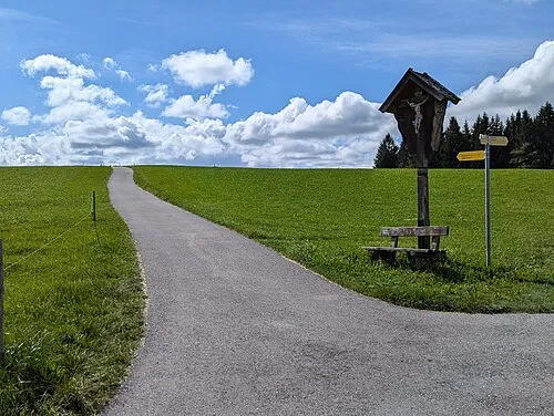
Wetzstein Molgreen · CC BY-SA 4.0

Climate of Mitterkirnberg
Best months for sightseeingBest months for sightseeing: June–September.
This month · November
A cold month
Day 6° · Night -2° · Rain 84 mm
- Hottest month
- July (day 21°)
- Coldest month
- January (night -6°)
- Wettest month
- July (161 mm)
- Driest month
- January (59 mm)
Bars: average monthly low and high temperature. Below: precipitation. Monthly averages for 1970–2000 at about 18 km resolution, adjusted for elevation. Highlighted months are mild and relatively dry. Source: WorldClim 2.1 (CC BY 4.0).
Show values as a table
| Month | Jan | Feb | Mar | Apr | May | Jun | Jul | Aug | Sep | Oct | Nov | Dec |
|---|---|---|---|---|---|---|---|---|---|---|---|---|
| Average high (°C) | 2° | 3° | 7° | 11° | 16° | 19° | 21° | 21° | 17° | 12° | 6° | 2° |
| Average low (°C) | -6° | -5° | -2° | 1° | 6° | 9° | 11° | 11° | 7° | 3° | -2° | -4° |
| Precipitation (mm) | 59 | 60 | 71 | 87 | 114 | 156 | 161 | 151 | 103 | 76 | 84 | 70 |
Other places to visit in this season: June July August September
How to get to Mitterkirnberg
The nearest airport is Innsbruck Airport (INN), 59 km to the southeast as the crow flies. The nearest large city is Innsbruck, 60 km to the southeast.
Airports
- Innsbruck Airport (INN) Innsbruck 59 kmsoutheast
- Memmingen Allgau Airport (FMM) Memmingen 64 kmnorthwest
- Munich Airport (MUC) Munich 91 kmnortheast
Nearby large cities
- Innsbruck Population: 132.5K 60 kmsoutheast
- Munich Population: 1.5M 62 kmnortheast
- Augsburg Population: 301.1K 71 kmnorth
- Ulm Population: 120.5K 105 kmnorthwest
- Ingolstadt Population: 120.7K 119 kmnorth
Straight-line distances; road distances are longer. Airport data: OurAirports.
Day trips from Mitterkirnberg
Within 100 km: 492 historic and cultural sites, 4,226 natural sites, 1,215 lakes, rivers and coasts.
0–25 km585 places
- Schloss Hirschberg am Haarsee Historic site 18 kmNE
- Kreuzspitzl Mountain 25 kmS
- Ammerwald Natural site 25 kmSW
- Roggentalbach River 25 kmSW
25–60 km2,007 places
- Bayerisches Oberland Mountain 29 kmE
- Wildsee Lake 48 kmS
- Weissensee Lake 42 kmS
- Vilsalpsee Lake 48 kmSW
60–100 km3,341 places
- elf-pavlik's tent Historic site 68 kmNE
- Kapfkopf Mountain 84 kmSW
- Bürkelkopf Mountain 96 kmSW
- Piz Murtèra Mountain 100 kmSW
Straight-line distances.
Nearby attractions & nature
Everything nearby-
Kohlbach River, Bavaria3.5 km NE
-
Lugenausee Lake, Bavaria3.5 km N
-
Ölberger Weiher Lake, Bavaria3.5 km W
-
Grambacher Wald Natural site, Bavaria3.9 km E
-
Golzenbach River, Bavaria3.9 km S
-
Finsterschachenwäldl Natural site, Bavaria4.5 km E
Sources & licences
Data last updated: