Stackendorf
Located in Buttenheim, Markt, Landkreis Bamberg Coordinates: 49°49′10″ N 11°04′51″ E

- Population
- 216
- 216
- Elevation
- 325 m
- above sea level
- Local time
- UTC+01:00
- Europe/Berlin · UTC+01:00
- Airports
- NUE Nuremberg Airport36 km
- ERF Erfurt-Weimar Airport129 km
About Stackendorf
Stackendorf is a village. Location: Buttenheim, Markt, Landkreis Bamberg. Population: 216. Elevation: 325 m.
Stackendorf is a small village located in Bavaria, Germany. It is in Upper Franconia, in the Bamberg district. Stackendorf is a constituent community of Buttenheim. In 2007, it had a population of 270.
Source: Wikipedia · CC BY-SA 4.0
Photos of Stackendorf
-
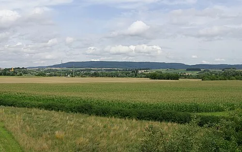
Friesener Warte Janericloebe · CC BY 3.0 -
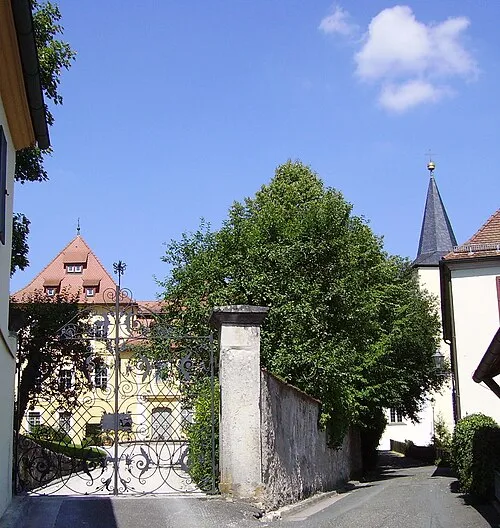
Schloss Unterleinleiter No machine-readable author provided. Immanuel Giel assumed · CC BY-SA 3.0


Population of Stackendorf over time
| 1875 | 151 | |
|---|---|---|
| 1925 | 164 | |
| 1950 | 216 | |
| 1970 | 180 | |
| 1987 | 198 |
Censuses and official estimates; source: Wikidata.
Climate of Stackendorf
Best months for sightseeingBest months for sightseeing: June–August.
This month · November
A cold month
Day 7° · Night 1° · Rain 59 mm
- Hottest month
- July (day 23°)
- Coldest month
- January (night -3°)
- Wettest month
- June (81 mm)
- Driest month
- February (48 mm)
Bars: average monthly low and high temperature. Below: precipitation. Monthly averages for 1970–2000 at about 18 km resolution, adjusted for elevation. Highlighted months are mild and relatively dry. Source: WorldClim 2.1 (CC BY 4.0).
Show values as a table
| Month | Jan | Feb | Mar | Apr | May | Jun | Jul | Aug | Sep | Oct | Nov | Dec |
|---|---|---|---|---|---|---|---|---|---|---|---|---|
| Average high (°C) | 2° | 4° | 9° | 13° | 19° | 21° | 23° | 23° | 19° | 13° | 7° | 4° |
| Average low (°C) | -3° | -3° | 0° | 2° | 7° | 10° | 12° | 11° | 8° | 4° | 1° | -2° |
| Precipitation (mm) | 59 | 48 | 56 | 50 | 62 | 81 | 81 | 58 | 60 | 63 | 59 | 70 |
How to get to Stackendorf
The nearest airport is Nuremberg Airport (NUE), 36 km to the south as the crow flies. The nearest large city is Erlangen, 26 km to the south.
Airports
- Nuremberg Airport (NUE) Nuremberg 36 kmsouth
- Erfurt-Weimar Airport (ERF) Erfurt 129 kmnorth
- Karlovy Vary Airport (KLV) Karlovy Vary 138 kmeast
Nearby large cities
- Erlangen Population: 102.7K 26 kmsouth
- Fürth Population: 132K 39 kmsouth
- Nuremberg Population: 515.5K 41 kmsouth
- Würzburg Population: 133.7K 81 kmwest
- Regensburg Population: 151.4K 116 kmsoutheast
Straight-line distances; road distances are longer. Airport data: OurAirports.
Day trips from Stackendorf
Within 100 km: 1,296 historic and cultural sites, 4,198 natural sites, 821 lakes, rivers and coasts.
0–25 km631 places
- Unterer Herrnsee Lake 14 kmSW
- Oberer Herrnsee Lake 14 kmSW
- Kleiner Bischofsweiher Lake 22 kmSW
- Haarweiher Lake 14 kmSW
25–60 km2,125 places
- Waldstadion Weismain Landmark 32 kmN
- Spitzelberg Mountain 39 kmSE
- Stollenberg Mountain 39 kmSE
- Deckersberg Mountain 46 kmSE
60–100 km3,559 places
- Uzbach River 72 kmSW
- Unterer Markweiher Lake 99 kmSE
- Thundorfer Weiher Lake 95 kmSE
- Süßenloher Weiher Lake 77 kmE
Straight-line distances.
Nearby attractions & nature
Everything nearby-
Senftenberg Mountain, Buttenheim, Markt0.7 km W
-
St.-Georgs-Kapelle auf dem Senftenberg Attraction, Buttenheim, Markt0.4 km W
-
Brand Mountain, Buttenheim, Markt1.1 km NW
-
Rosenknöcklein Mountain, Buttenheim, Markt1.5 km NE
-
Alte Kehrig Mountain, Buttenheim, Markt2 km N
-
Kautschenberg Mountain, Eggolsheim, Markt1.6 km E
Other cities and towns in Buttenheim, Markt
-
 Kälberberg Village, Buttenheim, Markt3.7 km N
-
Ketschendorf Village, Buttenheim, Markt2 km NW
Sources & licences
Data last updated: · 2 independent sources