- Population
- 49,697
- 49.7K
- Elevation
- 2 m
- above sea level
- Local time
- UTC+01:00
- Europe/Berlin · UTC+01:00
- Places inside
- 48
- listed under Cuxhaven
- Airports
- FCN Sea-Airport Cuxhaven/Nordholz / Nordholz Naval Airbase11 km
- HAM Hamburg Helmut Schmidt Airport88 km
About Cuxhaven
Cuxhaven is a village. Location: Landkreis Cuxhaven, Lower Saxony. Population: 49,697. Elevation: 2 m.
Cuxhaven (German: [kʊksˈhaːfn̩] ; Low German: Cuxhoben) is a port town and seat of the Cuxhaven district, in Lower Saxony, Germany. The town includes the northernmost point of Lower Saxony. The city serves as a gateway to the nearby Heligoland islands, a tax free zone off the coast of Germany. Cuxhaven is situated on the shore of the North Sea at the mouth of the Elbe River. Cuxhaven has a footprint of 14 kilometres (9 miles) (east–west) by 7 km (4 mi) (north–south).
Read more on Wikipedia Text: Wikipedia contributors · CC BY-SA 4.0 · shortened
In comparison
- Most populous of 29 places in Landkreis Cuxhaven
- Nearest larger town: Cuxhaven, 1 km NW
- 26 sights and natural places within 10 km Amtsgericht Cuxhaven, Sendeturm des Wasser- und Schiffahrtsamts Cuxhaven
- Listed here: Village: 16, Mountain: 13, Neighbourhood: 8, Landmark: 7
Twin towns and sister cities of Cuxhaven
- Binz· Germany
- City of New Bedford· United States
Source: Wikidata. Only places with a page on this site are shown.
Population of Cuxhaven over time
| 2014 | 48,221 | |
|---|---|---|
| 2016 | 48,551 | |
| 2017 | 48,470 | |
| 2019 | 48,358 | |
| 2020 | 48,356 | |
| 2021 | 48,318 | |
| 2022 | 48,562 | |
| 2023 | 48,713 | |
| 2024 | 49,697 | |
| 2025 | 49,545 |
Censuses and official estimates; source: Wikidata.
Climate of Cuxhaven
Best months for sightseeingBest months for sightseeing: June–August.
Bars: average monthly low and high temperature. Below: precipitation. Monthly averages for 1970–2000 at about 18 km resolution, adjusted for elevation. Highlighted months are mild and relatively dry. Source: WorldClim 2.1 (CC BY 4.0).
Show values as a table
| Month | Jan | Feb | Mar | Apr | May | Jun | Jul | Aug | Sep | Oct | Nov | Dec |
|---|---|---|---|---|---|---|---|---|---|---|---|---|
| Average high (°C) | 4° | 4° | 7° | 11° | 16° | 18° | 20° | 21° | 17° | 13° | 8° | 5° |
| Average low (°C) | 0° | 0° | 2° | 4° | 9° | 12° | 14° | 14° | 11° | 8° | 4° | 1° |
| Precipitation (mm) | 64 | 41 | 55 | 42 | 49 | 74 | 75 | 67 | 84 | 83 | 81 | 74 |
Airports nearest to Cuxhaven
- Sea-Airport Cuxhaven/Nordholz / Nordholz Naval Airbase (FCN) Wurster Nordseeküste 11 km
- Hamburg Helmut Schmidt Airport (HAM) Hamburg 88 km
- Bremen Airport (BRE) Bremen 90 km
Straight-line distance; airports with scheduled flights only. Source: OurAirports (public domain).
Places in Cuxhaven
48 places-
Cuxhaven Town52.7K
-
Döse Neighbourhood12.8K
-
Altenwalde Neighbourhood6.4K
-
Altenbruch Neighbourhood3.7K
-
Groden Village2.9K
-
Sahlenburg Village2.9K
-
Lüdingworth Village1.7K
-
Altenbruch-Westerende Neighbourhood
-
Amtsgericht Cuxhaven Attraction
-
Arensch Village
-
Berensch Neighbourhood
-
Buttsberg Mountain
-
Dicke Berta Landmark
-
Duhnen Village
-
Falkenhütte Mountain
-
Feuerberg Mountain
-
Franzenburg Village
-
Friedrich-Clemens-Gerke-Turm Landmark
-
Galgenberg Mountain
-
Großer Helmersberg Mountain
-
Gudendorf Village
-
Hohe Lieth Mountain
-
Holte Village
-
Höltjer Höhe Mountain
-
Höpenberg Mountain
-
Köstersweg Village
-
Kuhberg Mountain
-
Lüdingworth Westerende Neighbourhood
-
Naturschutzgebiet Cuxhavener Küstenheiden Natural site
-
NDB-Funkfeuer NDO Landmark
-
Osterende Neighbourhood
-
Ostergehren Village
-
Ostmast Küstenfunkstelle Sahlenburg Landmark
-
Oxstedt Village
-
Rammberg Mountain
-
Ritzebüttel Neighbourhood
-
Schodenbüttel Village
-
Sendemast Holter Höhe Landmark
-
Spangen Village
-
Stickenbüttel Village
-
Twellberg Mountain
-
Wehldorf Village
-
Wehrberg Mountain
-
Wernerwald Natural site
-
Westerwisch Village
-
Westmast Küstenfunkstelle Sahlenburg Landmark
-
Wolfsberg Mountain
Nearby attractions & nature
Everything nearby-
Brockswald Natural site, Lower Saxony4 km W
-
Voßberg Mountain, Wurster Nordseeküste10 km S
-
Elbe River River, Germany7.2 km N
-
Westermoorstrom River, Lower Saxony8.3 km S
-
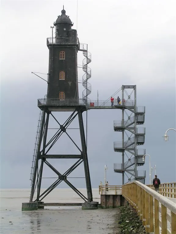 Leuchtturm Obereversand Landmark, Lower Saxony18 km SW
-
Grafenberg Mountain, Wanna13 km S
Sources & licences
Data last updated: · 2 independent sources