Granitz
Located in Binz, Landkreis Vorpommern-Rügen Coordinates: 54°23′34″ N 13°38′26″ E
- Elevation
- 17 m
- above sea level
- Airports
- HDF Heringsdorf Airport66 km
- RLG Rostock-Laage Airport103 km
About Granitz
Granitz is a natural site. Location: Binz, Landkreis Vorpommern-Rügen. The best months to visit are June–August. The nearest airport is Heringsdorf Airport (66 km). Nearby sights include Heideberg and Forst Werder.
Photos of Granitz
-
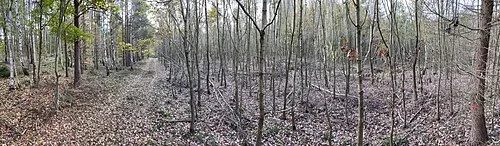
Forthberg Shisma · CC BY-SA 3.0

Climate of Granitz
Best months for sightseeingBest months for sightseeing: June–August.
This month · November
A cold month
Day 7° · Night 2° · Rain 53 mm
- Hottest month
- July (day 21°)
- Coldest month
- January (night -2°)
- Wettest month
- July (66 mm)
- Driest month
- February (32 mm)
Bars: average monthly low and high temperature. Below: precipitation. Monthly averages for 1970–2000 at about 18 km resolution, adjusted for elevation. Highlighted months are mild and relatively dry. Source: WorldClim 2.1 (CC BY 4.0).
Show values as a table
| Month | Jan | Feb | Mar | Apr | May | Jun | Jul | Aug | Sep | Oct | Nov | Dec |
|---|---|---|---|---|---|---|---|---|---|---|---|---|
| Average high (°C) | 2° | 3° | 6° | 10° | 15° | 19° | 21° | 21° | 17° | 12° | 7° | 4° |
| Average low (°C) | -2° | -2° | 0° | 2° | 7° | 11° | 13° | 13° | 10° | 6° | 2° | 0° |
| Precipitation (mm) | 38 | 32 | 37 | 35 | 46 | 55 | 66 | 64 | 56 | 50 | 53 | 47 |
How to get to Granitz
The nearest airport is Heringsdorf Airport (HDF), 66 km to the southeast as the crow flies. The nearest large city is Rostock, 103 km to the west.
Airports
- Heringsdorf Airport (HDF) Zirchow 66 kmsoutheast
- Rostock-Laage Airport (RLG) Laage 103 kmsouthwest
- Bornholm Airport (RNN) Rønne 104 kmnortheast
Nearby large cities
- Rostock Population: 198.3K 103 kmwest
- Malmö Population: 362.1K 141 kmnorth
- Copenhagen Population: 1.2M 159 kmnorthwest
- Helsingborg Population: 104.2K 194 kmnorth
- Lübeck Population: 212.2K 202 kmwest
Straight-line distances; road distances are longer. Airport data: OurAirports.
Day trips from Granitz
Within 100 km: 109 historic and cultural sites, 846 natural sites, 322 lakes, rivers and coasts.
0–25 km176 places
- Ruden Island 23 kmS
- Greifswalder Oie Island 24 kmSE
- Vilm Island 11 kmSW
- Hundestrand Beach 23 kmNW
25–60 km449 places
- Usedom Island Island 59 kmSE
- Hiddensee Island 39 kmNW
- Ummanz Island 32 kmW
- Insel Görmitz Island 45 kmSE
60–100 km652 places
- Wolin Island 77 kmSE
- Beeke River 88 kmSE
- Hundestrand Dierhagen Ost Beach 85 kmW
- Glippe Beach 81 kmW
Straight-line distances.
Nearest towns and villages
-
Ostseebad Binz Town, Binz2.1 km W
-
 Sellin Village, Landkreis Vorpommern-Rügen2.7 km SE
-
Lancken-Granitz Village, Lancken-Granitz3 km S
-
Lancken-Granitz Village, Landkreis Vorpommern-Rügen2.9 km S
-
Sellin Village, Sellin3.8 km SE
-
Blieschow Village, Lancken-Granitz1.8 km S
Nearby attractions & nature
Everything nearby-
Heideberg Mountain, Binz0.8 km W
-
Forst Werder Natural site, Binz0.9 km SE
-
Waldhalle Mountain, Sellin2 km SE
-
Forthberg Mountain, Sellin2 km SE
-
Tempelberg Mountain, Binz1.6 km SW
-
Naturschutzgebiet Granitz Natural site, Binz1.6 km SW
-
Fahrenberg Mountain, Zirkow2.8 km W
-
Falkenberg Mountain, Sellin2.4 km E
Sources & licences
Data last updated: