- Elevation
- 3 m
- above sea level
- Local time
- UTC+01:00
- Europe/Berlin · UTC+01:00
- Airports
- LBC Lübeck Blankensee Airport23 km
- HAM Hamburg Helmut Schmidt Airport73 km
About Strand Rosenhagen
Strand Rosenhagen is a beach. Location: Dassow, Nordwestmecklenburg. The best months to visit are June–August. The nearest airport is Lübeck Blankensee Airport (23 km). Nearby sights include Naturschutzgebiet Küstenlanschaft zwischen Priwall und Barendorf mit Harkenbäkniederung and Harkenbäk.
Photos of Strand Rosenhagen
-
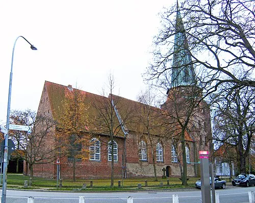
St. Lorenz Roland.h.bueb · CC BY 3.0

Climate of Strand Rosenhagen
Best months for sightseeingBest months for sightseeing: June–August.
This month · November
A cold month
Day 7° · Night 3° · Rain 60 mm
- Hottest month
- August (day 22°)
- Coldest month
- January (night -2°)
- Wettest month
- July (67 mm)
- Driest month
- February (37 mm)
Bars: average monthly low and high temperature. Below: precipitation. Monthly averages for 1970–2000 at about 18 km resolution, adjusted for elevation. Highlighted months are mild and relatively dry. Source: WorldClim 2.1 (CC BY 4.0).
Show values as a table
| Month | Jan | Feb | Mar | Apr | May | Jun | Jul | Aug | Sep | Oct | Nov | Dec |
|---|---|---|---|---|---|---|---|---|---|---|---|---|
| Average high (°C) | 3° | 4° | 7° | 11° | 16° | 19° | 21° | 22° | 17° | 13° | 7° | 4° |
| Average low (°C) | -2° | -1° | 1° | 3° | 7° | 11° | 13° | 12° | 10° | 6° | 3° | 0° |
| Precipitation (mm) | 56 | 37 | 51 | 42 | 46 | 62 | 67 | 62 | 56 | 55 | 60 | 64 |
How to get to Strand Rosenhagen
The nearest airport is Lübeck Blankensee Airport (LBC), 23 km to the southwest as the crow flies. For international flights: Hamburg Helmut Schmidt Airport (HAM) (73 km). The nearest large city is Lübeck, 19 km to the southwest.
Airports
- Lübeck Blankensee Airport (LBC) Lübeck 23 kmsouthwest
- Hamburg Helmut Schmidt Airport (HAM) Hamburg 73 kmsouthwest
- Rostock-Laage Airport (RLG) Laage 88 kmeast
Nearby large cities
- Lübeck Population: 212.2K 19 kmsouthwest
- Kiel Population: 252.7K 66 kmnorthwest
- Rostock Population: 198.3K 80 kmeast
- Bremerhaven Population: 118.6K 162 kmwest
- Odense Population: 180.9K 163 kmnorth
Straight-line distances; road distances are longer. Airport data: OurAirports.
Day trips from Strand Rosenhagen
Within 100 km: 313 historic and cultural sites, 2,794 natural sites, 1,244 lakes, rivers and coasts.
0–25 km278 places
- Hundestrand Beach 15 kmNW
- Hundestrand 1 Beach 3 kmNE
- Strand Kalkhorst Beach 4 kmNE
- Meerwasser-Wellenbad Beach 14 kmNW
25–60 km1,629 places
- Fehmarn Island 58 kmN
- Poel Island Island 33 kmE
- Ziegelwerder Island 53 kmSE
- Köppernitz River 35 kmE
60–100 km2,444 places
- Viertbusch Natural site 64 kmSW
- Spock River 62 kmNW
- Aubek River 81 kmW
- Beke River 67 kmE
Straight-line distances.
Nearest towns and villages
-
Pötenitz Village, Dassow2 km S
-
 Travemünde Neighbourhood, Lübeck, Hansestadt4.2 km W
-
Rosenhagen Village, Dassow0.5 km SE
-
Harkensee Village, Dassow2.8 km E
-
Barendorf Village, Dassow1.9 km E
-
Hof Barendorf Village, Dassow2 km E
Nearby attractions & nature
Everything nearby-
Naturschutzgebiet Küstenlanschaft zwischen Priwall und Barendorf mit Harkenbäkniederung Natural site, Dassow1.3 km NE
-
Harkenbäk River, Mecklenburg-Vorpommern1.3 km E
-
Klodtenberg Mountain, Dassow2.3 km E
-
Katzbach River, Dassow2 km SE
-
Schlossberg Mountain, Dassow2.6 km SE
-
Deipsee Lake, Dassow2.3 km SE
-
Johannstorfer Berg Mountain, Dassow2.8 km S
-
Schipmannsberg Mountain, Dassow3.4 km SE
Sources & licences
Data last updated: