- Population
- 262,670
- 262.7K
- Elevation
- 168 m
- above sea level
- Local time
- UTC+01:00
- Europe/Berlin · UTC+01:00
- Places inside
- 69
- listed under Aachen
- Airports
- MST Maastricht Aachen Airport27 km
- LGG Liège Airport48 km
About Aachen
Aachen is a village. Location: Städteregion Aachen, Cologne District. Population: 262,670. Elevation: 168 m.
Aachen is the 13th-largest city in North Rhine-Westphalia and the 27th-largest city of Germany, with around 264,000 inhabitants. It is the western-most major city in Germany, lying approximately 61 km (38 mi) west of Cologne and Bonn, directly bordering Belgium in the southwest, and the Netherlands in the northwest. The city lies in the Meuse–Rhine Euroregion and is the seat of the district of Aachen (Städteregion Aachen).
Source: Wikipedia · CC BY-SA 4.0
Photos of Aachen
-
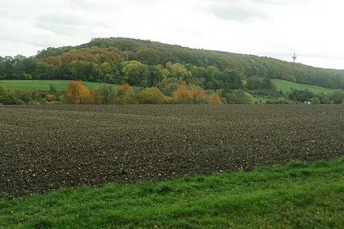
Friedrich Ahoerstemeier · CC BY-SA 4.0

Places bordering Aachen
- Raeren
Twin towns and sister cities of Aachen
- Toledo· Spain
- Arlington County· United States
Source: Wikidata. Only places with a page on this site are shown.
Population of Aachen over time
| 2011 | 238,665 | |
|---|---|---|
| 2012 | 240,086 | |
| 2014 | 243,336 | |
| 2015 | 245,885 | |
| 2016 | 254,782 | |
| 2017 | 246,272 | |
| 2019 | 247,380 | |
| 2021 | 249,070 | |
| 2022 | 252,136 | |
| 2023 | 252,769 | |
| 2024 | 262,670 | |
| 2025 | 263,703 |
Censuses and official estimates; source: Wikidata.
Climate of Aachen
Best months for sightseeingBest months for sightseeing: June–August.
This month · November
A cold month
Day 9° · Night 3° · Rain 78 mm
- Hottest month
- August (day 22°)
- Coldest month
- February (night 0°)
- Wettest month
- December (86 mm)
- Driest month
- April (62 mm)
Bars: average monthly low and high temperature. Below: precipitation. Monthly averages for 1970–2000 at about 18 km resolution, adjusted for elevation. Highlighted months are mild and relatively dry. Source: WorldClim 2.1 (CC BY 4.0).
Show values as a table
| Month | Jan | Feb | Mar | Apr | May | Jun | Jul | Aug | Sep | Oct | Nov | Dec |
|---|---|---|---|---|---|---|---|---|---|---|---|---|
| Average high (°C) | 5° | 6° | 9° | 13° | 17° | 20° | 22° | 22° | 18° | 14° | 9° | 6° |
| Average low (°C) | 0° | 0° | 3° | 4° | 9° | 11° | 13° | 13° | 10° | 7° | 3° | 2° |
| Precipitation (mm) | 77 | 70 | 78 | 62 | 72 | 82 | 84 | 73 | 75 | 70 | 78 | 86 |
How to get to Aachen
The nearest airport is Maastricht Aachen Airport (MST), 27 km to the northwest as the crow flies. The nearest large city is Aachen, 1 km to the west.
Airports
- Maastricht Aachen Airport (MST) Maastricht 27 kmnorthwest
- Liège Airport (LGG) Grâce-Hollogne 48 kmwest
- Düsseldorf Airport (DUS) Düsseldorf 74 kmnortheast
Nearby large cities
- Aachen Population: 265.2K 1 kmwest
- Maastricht Population: 122.4K 29 kmwest
- Liège Population: 195.3K 40 kmsouthwest
- Mönchengladbach Population: 261.7K 52 kmnortheast
- Neuss Population: 152.5K 63 kmnortheast
Straight-line distances; road distances are longer. Airport data: OurAirports.
Day trips from Aachen
Within 100 km: 455 historic and cultural sites, 2,051 natural sites, 903 lakes, rivers and coasts.
0–25 km145 places
- Lac de la Gileppe Lake 22 kmS
- Lac d'Eupen Lake 17 kmS
- Vrouwenbos Natural site 18 kmW
- Veursbos Natural site 17 kmW
25–60 km963 places
- Île du Moulin Island 42 kmSW
- Île Monsin Island 34 kmW
- Île de Franche Garenne Island 30 kmW
- Lac de Robertville Lake 37 kmS
60–100 km2,301 places
- Lac de Nisramont Lake 77 kmSW
- Vijvers van Bellefroid Lake 99 kmW
- Wijngaardberg Mountain 95 kmW
- Wetsberg Mountain 80 kmNW
Straight-line distances.
Places in Aachen
69 placesBar: population relative to the most populous place in this list.
Cities & villages38
- Bildchen · Village
- Brand · Neighbourhood
- Brandenburg · Village
- Burtscheid · Neighbourhood
- Eich · Village
- Eilendorf · Village
- Entenplatz · Village
- Forst · Neighbourhood
- Försterheide · Village
- Frankenberger Viertel · Village
- Freund · Village
- Friesenrath · Village
- Grünenthal · Village
- Haaren · Neighbourhood
- Hahn · Village
- Hand · Village
- Hitfeld · Village
- Horbach · Village
- Hörn · Neighbourhood
- Kornelimünster · Neighbourhood
- Krauthausen · Village
- Laurensberg · Neighbourhood
- Lichtenbusch · Village
- Marienthal · Village
- Melaten · Village
- Niederforstbach · Village
- Nütheim · Village
- Oberforstbach · Neighbourhood
- Orsbach · Village
- Preuswald · Neighbourhood
- Richterich · Neighbourhood
- Rothe Erde · Neighbourhood
- Schleckheim · Village
- Schmithof · Village
- Seffent · Village
- Sief · Village
- Soers · Neighbourhood
- Steinebrück · Neighbourhood
Mountains & nature9
- Brandenberg · Mountain
- Düsberg · Mountain
- Elleterberg · Mountain
- Friedrich · Mountain
- Hangeweiher · Natural site
- Klausberg · Mountain
- Königshügel · Mountain
- Lousberg · Mountain
- Schneeberg · Mountain
Heritage & sights11
- Aachen Suermondt-Museum · Museum
- Abteikirche St. Johann-Baptist in Burtscheid · Attraction
- Bergdriesch 4 · Historic site
- Brandenberg Tower · Historic site
- Dom Aachen · Attraction
- Fernmeldeturm Aachen · Landmark
- Long Tower · Historic site
- Marching Gate · Historic site
- Mary Tower · Historic site
- Pont Gate · Historic site
- Preach Tower · Historic site
Nearby attractions & nature
Everything nearby-
Sieben Quellen Natural site, Cologne District3.6 km W
-
Beverbach River, North Rhine-Westphalia3.6 km SE
-
Aachener Stadtforst Natural site, North Rhine-Westphalia4.9 km S
-
Augustiner Wald Natural site, North Rhine-Westphalia5.6 km SE
-
Preuswald Natural site, Belgium6.9 km SW
-
Landwehring Natural site, Liège Province7 km S
Other cities and towns in Städteregion Aachen
-
Vaalserquartier Neighbourhood, Aachen4.2 km W
-
 Verlautenheide Village, Aachen5.3 km NE
-
Vetschau Village, Aachen5.4 km NW
-
Wildbach Village, Aachen2.7 km N
-
Steppenberg Village, Aachen3.4 km W
Sources & licences
Data last updated: · 2 independent sources