- Elevation
- 26 m
- above sea level
- Local time
- UTC+01:00
- Europe/Berlin · UTC+01:00
- Airports
- NRN Weeze (Niederrhein) Airport27 km
- DUS Düsseldorf Airport30 km
About Dachsbruch
Dachsbruch is a village. Location: Kamp-Lintfort, Kreis Wesel. Elevation: 26 m. The best months to visit are June–August. The nearest airport is Weeze (Niederrhein) Airport (27 km). Nearby sights include Dachsberg and Eyller Berg.
Photos of Dachsbruch
-
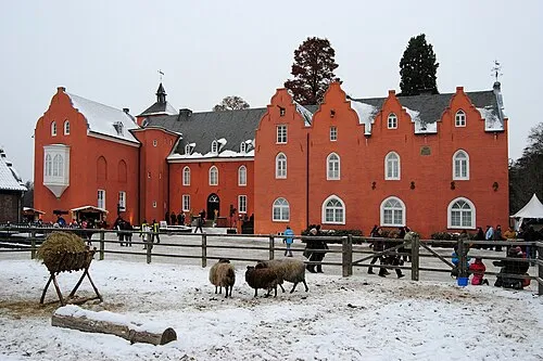
Schloß Bloemersheim kaʁstn Disk / Cat · CC BY-SA 3.0

Climate of Dachsbruch
Best months for sightseeingBest months for sightseeing: June–August.
This month · November
A cold month
Day 9° · Night 4° · Rain 65 mm
- Hottest month
- August (day 23°)
- Coldest month
- February (night 0°)
- Wettest month
- June (74 mm)
- Driest month
- April (46 mm)
Bars: average monthly low and high temperature. Below: precipitation. Monthly averages for 1970–2000 at about 18 km resolution, adjusted for elevation. Highlighted months are mild and relatively dry. Source: WorldClim 2.1 (CC BY 4.0).
Show values as a table
| Month | Jan | Feb | Mar | Apr | May | Jun | Jul | Aug | Sep | Oct | Nov | Dec |
|---|---|---|---|---|---|---|---|---|---|---|---|---|
| Average high (°C) | 5° | 6° | 10° | 14° | 19° | 21° | 23° | 23° | 19° | 14° | 9° | 6° |
| Average low (°C) | 0° | 0° | 3° | 5° | 9° | 11° | 13° | 13° | 10° | 7° | 4° | 2° |
| Precipitation (mm) | 62 | 48 | 62 | 46 | 64 | 74 | 68 | 60 | 64 | 60 | 65 | 70 |
How to get to Dachsbruch
The nearest airport is Weeze (Niederrhein) Airport (NRN), 27 km to the northwest as the crow flies. The nearest large city is Moers, 11 km to the southeast.
Airports
- Weeze (Niederrhein) Airport (NRN) Weeze 27 kmnorthwest
- Düsseldorf Airport (DUS) Düsseldorf 30 kmsoutheast
- Eindhoven Airport (EIN) Eindhoven 78 kmwest
Nearby large cities
- Moers Population: 103.5K 11 kmsoutheast
- Krefeld Population: 238K 18 kmsouth
- Duisburg Population: 504.4K 20 kmeast
- Oberhausen Population: 219.2K 26 kmeast
- Venlo Population: 102K 26 kmsouthwest
Straight-line distances; road distances are longer. Airport data: OurAirports.
Day trips from Dachsbruch
Within 100 km: 373 historic and cultural sites, 815 natural sites, 535 lakes, rivers and coasts.
0–25 km152 places
- Kasteel Arcen Historic site 21 kmW
- Schrolik Lake 23 kmSW
- Schönwasser Lake 18 kmS
- Poelvenn Lake 22 kmSW
25–60 km423 places
- Itterbeek River 57 kmSW
- Witbeek River 59 kmSW
- Wijlermeer Lake 52 kmNW
- Strang Lake 45 kmNW
60–100 km1,148 places
- Schemersberg Mountain 92 kmSW
- Zeven-Heerlijkhedenheide Natural site 93 kmW
- Warandeheide Natural site 92 kmW
- Vrouwenbos Natural site 96 kmSW
Straight-line distances.
Nearby attractions & nature
Everything nearby-
Dachsberg Mountain, Kamp-Lintfort1 km E
-
Eyller Berg Mountain, Kamp-Lintfort2 km SE
-
Kloster Kamp Attraction, Kamp-Lintfort2.1 km NE
-
Niersenberg Mountain, Kamp-Lintfort3.3 km NE
-
Eyllsche Kendel River, North Rhine-Westphalia2 km NE
-
Vluynbusch Natural site, North Rhine-Westphalia2.6 km SE
Sources & licences
Data last updated: