Kreisfreie Stadt Trier
Local name: Trier
Located in Rhineland-Palatinate, Germany Coordinates: 49°46′09″ N 6°40′30″ E
- Population
- 104,342
- 104.3K
- Elevation
- 135 m
- above sea level
- Local time
- UTC+01:00
- Europe/Berlin · UTC+01:00
- Places inside
- 1
- listed under Kreisfreie Stadt Trier
- Airports
- LUX Luxembourg-Findel International Airport37 km
- HHN Frankfurt-Hahn Airport47 km
About Kreisfreie Stadt Trier
Kreisfreie Stadt Trier is a municipality. Location: Rhineland-Palatinate, Germany. Population: 104,342. Elevation: 135 m.
Trier ( TREER, German: [tʁiːɐ̯] ; Luxembourgish: Tréier [ˈtʀɜɪ̯ɐ] ), formerly and traditionally known in English as Trèves ( TREV, French: [tʁɛv] ) and Triers (see also names in other languages), is a city on the banks of the Moselle in Germany. It lies in a valley between low vine-covered hills of red sandstone in the west of the state of Rhineland-Palatinate, near the border with Luxembourg and within the Moselle wine region.
Source: Wikipedia · CC BY-SA 4.0
Photos of Kreisfreie Stadt Trier
-
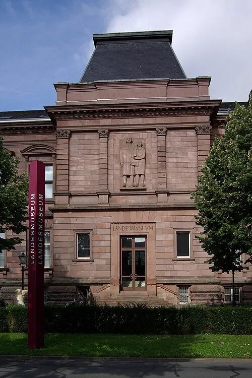
Rheinisches Landesmuseum Trier Berthold Werner · Public domain

Twin towns and sister cities of Kreisfreie Stadt Trier
- Pula· Croatia
- 's-Hertogenbosch· The Netherlands
- Fort Worth· United States
- Nagaoka Shi· Japan
Source: Wikidata. Only places with a page on this site are shown.
Population of Kreisfreie Stadt Trier over time
| 1975 | 100,338 | |
|---|---|---|
| 2010 | 105,260 | |
| 2014 | 108,472 | |
| 2015 | 114,914 | |
| 2016 | 110,111 | |
| 2017 | 110,013 | |
| 2019 | 110,636 | |
| 2021 | 110,570 | |
| 2022 | 112,195 | |
| 2023 | 112,737 | |
| 2024 | 104,342 | |
| 2025 | 105,054 |
Censuses and official estimates; source: Wikidata.
Climate of Kreisfreie Stadt Trier
Best months for sightseeingBest months for sightseeing: June–August.
This month · November
A cold month
Day 8° · Night 3° · Rain 81 mm
- Hottest month
- July (day 24°)
- Coldest month
- January (night 0°)
- Wettest month
- December (92 mm)
- Driest month
- April (58 mm)
Bars: average monthly low and high temperature. Below: precipitation. Monthly averages for 1970–2000 at about 18 km resolution, adjusted for elevation. Highlighted months are mild and relatively dry. Source: WorldClim 2.1 (CC BY 4.0).
Show values as a table
| Month | Jan | Feb | Mar | Apr | May | Jun | Jul | Aug | Sep | Oct | Nov | Dec |
|---|---|---|---|---|---|---|---|---|---|---|---|---|
| Average high (°C) | 4° | 6° | 10° | 13° | 18° | 21° | 24° | 24° | 19° | 14° | 8° | 5° |
| Average low (°C) | 0° | 0° | 2° | 5° | 9° | 12° | 14° | 13° | 10° | 7° | 3° | 1° |
| Precipitation (mm) | 78 | 65 | 71 | 58 | 72 | 74 | 74 | 61 | 68 | 79 | 81 | 92 |
How to get to Kreisfreie Stadt Trier
The nearest airport is Luxembourg-Findel International Airport (LUX), 37 km to the southwest as the crow flies. The nearest large city is Trier, 3 km to the southwest.
Airports
- Luxembourg-Findel International Airport (LUX) Luxembourg 37 kmsouthwest
- Frankfurt-Hahn Airport (HHN) Frankfurt am Main (Lautzenhausen) 47 kmnortheast
- Saarbrücken Airport (SCN) Saarbrücken 69 kmsoutheast
Nearby large cities
- Trier Population: 100.1K 3 kmsouthwest
- Saarbrücken Population: 183K 64 kmsouth
- Metz Population: 123.9K 81 kmsouthwest
- Koblenz Population: 107.3K 92 kmnortheast
- Bonn Population: 330.6K 111 kmnorth
Straight-line distances; road distances are longer. Airport data: OurAirports.
Day trips from Kreisfreie Stadt Trier
Within 100 km: 398 historic and cultural sites, 2,988 natural sites, 752 lakes, rivers and coasts.
0–25 km185 places
- Sauer River 12 kmW
- Zoonenberg Mountain 8 kmN
- Steinkopf Mountain 25 kmE
- Schneeberg Mountain 22 kmS
25–60 km1,196 places
- Steinkopf Mountain 59 kmNW
- Kindel Busch Natural site 60 kmW
- Grossen Busch Natural site 60 kmW
- Eichenbusch Natural site 58 kmNW
60–100 km2,757 places
- Étang des Épioux Lake 99 kmW
- Lac de Nisramont Lake 84 kmNW
- Lac de Robertville Lake 85 kmNW
- Mont de la Tour de Coo Mountain 91 kmNW
Straight-line distances.
Kreisfreie Stadt Trier and similar cities
Side by side with cities of similar size in the same country: population, elevation and climate.
| Measure | Kreisfreie Stadt Trier | Gera | Jena | Salzgitter |
|---|---|---|---|---|
| Population | 104.3K | 104.7K | 104.7K | 105K |
| Elevation | 135 m | 203 m | 149 m | 99 m |
| Summer day (hottest month) | 24° | 24° | 24° | 23° |
| Winter night (coldest month) | 0° | -2° | -2° | -2° |
| Annual rainfall | 873 mm | 602 mm | 644 mm | 674 mm |
| Best months | Jun–Aug | Jun–Sep | May–Sep | Jun–Aug |
| Distance | — | 404 km | 373 km | 374 km |
Climate values are 1970–2000 monthly averages; straight-line distance.
Places in Kreisfreie Stadt Trier
1 placeBar: population relative to the most populous place in this list.
Nearby attractions & nature
Everything nearby-
Grünen Wald Natural site, Rhineland-Palatinate3 km E
-
Ruwer River, Rhineland-Palatinate2.8 km NE
-
Gillenbach River, Rhineland-Palatinate3 km W
-
Klink Bach River, Rhineland-Palatinate3.4 km NW
-
Loricher Bach River, Rhineland-Palatinate3.6 km NW
-
Aacher Bach River, Rhineland-Palatinate3.7 km NW
-
Kyll River, Rhineland-Palatinate4.3 km NE
-
Hochburg Mountain, Kordel5 km N
Other cities and towns in Rhineland-Palatinate
-
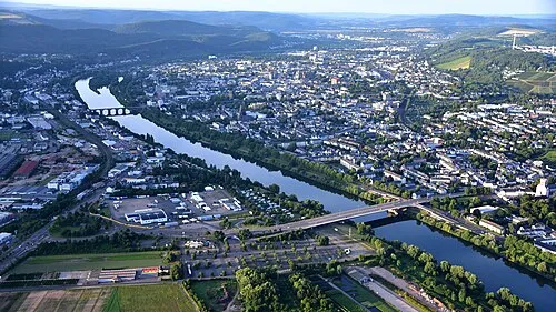 Trier City, Trier3 km SW
-
Konz Town, Konz10 km SW
-
Ehrang Town, Trier5.5 km N
-
Schweich Town, Schweich8.1 km NE
-
Landkreis Bernkastel-Wittlich Municipality, Rhineland-Palatinate29 km NE
-
Vulkaneifel Municipality, Rhineland-Palatinate54 km N
Sources & licences
Data last updated: · 2 independent sources