Cochem
Located in Landkreis Cochem-Zell, Rhineland-Palatinate Coordinates: 50°08′35″ N 7°10′44″ E

- Population
- 4,946
- 4.9K
- Elevation
- 263 m
- above sea level
- Local time
- UTC+01:00
- Europe/Berlin · UTC+01:00
- Places inside
- 10
- listed under Cochem
- Airports
- HHN Frankfurt-Hahn Airport23 km
- CGN Cologne Bonn Airport80 km
About Cochem
Cochem is a village. Location: Landkreis Cochem-Zell, Rhineland-Palatinate. Population: 4,946. Elevation: 263 m.
Cochem (German pronunciation: [ˈkɔxm̩] ) is a town in Rhineland-Palatinate, Germany. Situated on the banks of the Moselle River, it is the administrative seat of the Cochem-Zell district and its largest town with around 5,300 inhabitants. The town is known for its riverside setting, historic old town, and the hilltop Reichsburg Cochem, which overlooks the Moselle valley. First mentioned in the Early Middle Ages, Cochem developed as a regional centre of trade and viticulture within the Electorate of Trier.
Source: Wikipedia · CC BY-SA 4.0
Photos of Cochem
-
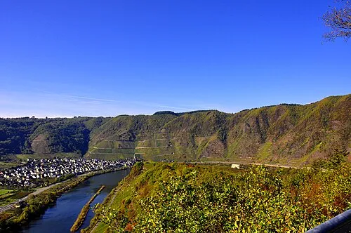
Calmont H.Peierl · CC BY 3.0 -
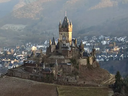
Reichsburg Cochem Holger Weinandt · CC BY-SA 3.0 -
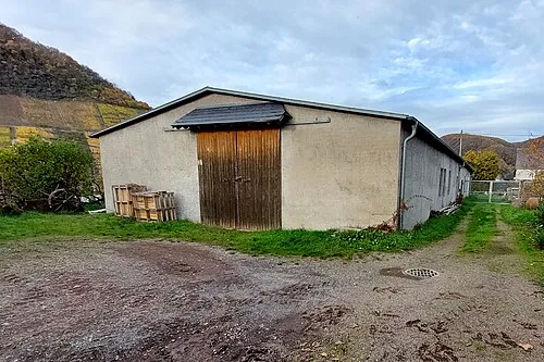
Kochem Concentration Camp (Zeisig, A 7) RomkeHoekstra · CC BY-SA 4.0


Twin towns and sister cities of Cochem
- Malmedy· Belgium
Source: Wikidata. Only places with a page on this site are shown.
Population of Cochem over time
| 1975 | 6,583 | |
|---|---|---|
| 2014 | 5,259 | |
| 2017 | 5,332 | |
| 2019 | 5,312 | |
| 2021 | 5,199 | |
| 2022 | 5,288 | |
| 2023 | 5,346 | |
| 2024 | 4,946 | |
| 2025 | 4,897 |
Censuses and official estimates; source: Wikidata.
Climate of Cochem
Best months for sightseeingBest months for sightseeing: June–August.
This month · November
A cold month
Day 7° · Night 2° · Rain 64 mm
- Hottest month
- July (day 23°)
- Coldest month
- February (night -1°)
- Wettest month
- December (72 mm)
- Driest month
- February (51 mm)
Bars: average monthly low and high temperature. Below: precipitation. Monthly averages for 1970–2000 at about 18 km resolution, adjusted for elevation. Highlighted months are mild and relatively dry. Source: WorldClim 2.1 (CC BY 4.0).
Show values as a table
| Month | Jan | Feb | Mar | Apr | May | Jun | Jul | Aug | Sep | Oct | Nov | Dec |
|---|---|---|---|---|---|---|---|---|---|---|---|---|
| Average high (°C) | 3° | 5° | 9° | 12° | 18° | 20° | 23° | 22° | 18° | 13° | 7° | 4° |
| Average low (°C) | -1° | -1° | 2° | 4° | 8° | 11° | 13° | 13° | 10° | 6° | 2° | 0° |
| Precipitation (mm) | 60 | 51 | 59 | 54 | 67 | 69 | 65 | 59 | 61 | 65 | 64 | 72 |
How to get to Cochem
The nearest airport is Frankfurt-Hahn Airport (HHN), 23 km to the south as the crow flies. The nearest large city is Koblenz, 37 km to the northeast.
Airports
- Frankfurt-Hahn Airport (HHN) Frankfurt am Main (Lautzenhausen) 23 kmsouth
- Cologne Bonn Airport (CGN) Köln (Cologne) 80 kmnorth
- Luxembourg-Findel International Airport (LUX) Luxembourg 90 kmsouthwest
Nearby large cities
- Koblenz Population: 107.3K 37 kmnortheast
- Trier Population: 100.1K 58 kmsouthwest
- Bonn Population: 330.6K 66 kmnorth
- Wiesbaden Population: 288.8K 76 kmeast
- Mainz Population: 222.9K 81 kmeast
Straight-line distances; road distances are longer. Airport data: OurAirports.
Day trips from Cochem
Within 100 km: 628 historic and cultural sites, 3,538 natural sites, 889 lakes, rivers and coasts.
0–25 km294 places
- Hatzenporter Werth Island 19 kmNE
- Weinfelder Maar Lake 24 kmW
- Pulvermaar Lake 18 kmW
- Gemündener Maar Lake 25 kmW
25–60 km2,045 places
- Schartenknopf Mountain 59 kmW
- Urbach River 49 kmNE
- Rüdesheimer Aue Island 57 kmE
- Meerfelder Maar Lake 30 kmW
60–100 km2,716 places
- Lac de la Gileppe Lake 98 kmNW
- Lac d'Eupen Lake 93 kmNW
- Lac de Robertville Lake 83 kmNW
- Mont de la Tour de Coo Mountain 98 kmW
Straight-line distances.
Places in Cochem
10 placesBar: population relative to the most populous place in this list.
Cities & villages4
- Brauheck · Village
- Ebernach · Village
- Hahnenstein · Village
- Sehl · Village
Mountains & nature1
- Göftberg · Mountain
Heritage & sights4
- Cochem Castle · Historic site
- Kochem Concentration Camp (Zeisig, A 7) · Historic site
- Reichsburg Cochem · Historic site
- Winneburg · Historic site
Nearby attractions & nature
Everything nearby-
Endertbach River, Rhineland-Palatinate1.4 km NW
-
Ellerberg Mountain, Ediger-Eller2.7 km SW
-
Jünkernwald Natural site, Rhineland-Palatinate2.9 km NW
-
Kader Bach River, Rhineland-Palatinate3.1 km NE
-
Calmont Mountain, Ediger-Eller5.3 km SW
-
Wahl-Berg Mountain, Briedern5 km SE
Other cities and towns in Landkreis Cochem-Zell


Sources & licences
Data last updated: · 2 independent sources