Lahnstein
Located in Rhein-Lahn-Kreis, Rhineland-Palatinate Coordinates: 50°18′14″ N 7°37′29″ E

- Population
- 18,719
- 18.7K
- Elevation
- 209 m
- above sea level
- Local time
- UTC+01:00
- Europe/Berlin · UTC+01:00
- Places inside
- 15
- listed under Lahnstein
- Airports
- HHN Frankfurt-Hahn Airport47 km
- CGN Cologne Bonn Airport71 km
About Lahnstein
Lahnstein is a village. Location: Rhein-Lahn-Kreis, Rhineland-Palatinate. Population: 18,719. Elevation: 209 m.
Lahnstein (German pronunciation: [ˈlaːnʃtaɪn] ) is a verband-free town of Rhein-Lahn-Kreis in Rhineland-Palatinate, Germany. It is situated at the confluence of the Lahn with the Rhine, approximately 6 kilometres (3.7 mi) south of Koblenz. Lahnstein was created in 1969 by the merger of the previously independent towns of Oberlahnstein (or Upper Lahnstein) on the south side of the Lahn (above the river mouth) and Niederlahnstein on the north side (below the river mouth). In 2020, it had a population of 18,030.
Source: Wikipedia · CC BY-SA 4.0
Photos of Lahnstein
-

Unknown author Unknown author · CC BY 4.0 -

Unknown author Unknown author · CC BY 4.0 -

G. Lameck; Rhein-Museum Koblenz · CC BY 4.0 -

LightSpirit888 · CC0 -

Kreuzschnabel · CC BY-SA 3.0


Population of Lahnstein over time
| 1975 | 19,725 | |
|---|---|---|
| 2015 | 17,973 | |
| 2017 | 17,939 | |
| 2018 | 18,067 | |
| 2019 | 18,067 | |
| 2021 | 18,111 | |
| 2022 | 18,433 | |
| 2023 | 18,536 | |
| 2024 | 18,719 | |
| 2025 | 18,887 |
Censuses and official estimates; source: Wikidata.
Climate of Lahnstein
Best months for sightseeingBest months for sightseeing: June–August.
This month · November
A cold month
Day 8° · Night 3° · Rain 61 mm
- Hottest month
- July (day 23°)
- Coldest month
- February (night -1°)
- Wettest month
- July (74 mm)
- Driest month
- February (47 mm)
Bars: average monthly low and high temperature. Below: precipitation. Monthly averages for 1970–2000 at about 18 km resolution, adjusted for elevation. Highlighted months are mild and relatively dry. Source: WorldClim 2.1 (CC BY 4.0).
Show values as a table
| Month | Jan | Feb | Mar | Apr | May | Jun | Jul | Aug | Sep | Oct | Nov | Dec |
|---|---|---|---|---|---|---|---|---|---|---|---|---|
| Average high (°C) | 4° | 5° | 9° | 13° | 18° | 21° | 23° | 23° | 19° | 13° | 8° | 5° |
| Average low (°C) | -1° | -1° | 2° | 4° | 8° | 11° | 13° | 13° | 10° | 6° | 3° | 1° |
| Precipitation (mm) | 55 | 47 | 56 | 53 | 66 | 71 | 74 | 59 | 60 | 62 | 61 | 65 |
How to get to Lahnstein
The nearest airport is Frankfurt-Hahn Airport (HHN), 47 km to the southwest as the crow flies. The nearest large city is Koblenz, 6 km to the northwest.
Airports
- Frankfurt-Hahn Airport (HHN) Frankfurt am Main (Lautzenhausen) 47 kmsouthwest
- Cologne Bonn Airport (CGN) Köln (Cologne) 71 kmnorthwest
- Frankfurt Main Airport (FRA) Frankfurt am Main 73 kmsoutheast
Nearby large cities
- Koblenz Population: 107.3K 6 kmnorthwest
- Wiesbaden Population: 288.8K 50 kmsoutheast
- Mainz Population: 222.9K 59 kmsoutheast
- Bonn Population: 330.6K 61 kmnorthwest
- Siegen Population: 107.2K 70 kmnortheast
Straight-line distances; road distances are longer. Airport data: OurAirports.
Day trips from Lahnstein
Within 100 km: 763 historic and cultural sites, 4,023 natural sites, 932 lakes, rivers and coasts.
0–25 km459 places
- Urbach River 25 kmN
- Hatzenporter Werth Island 18 kmSW
- Höhr Mountain 6 kmNE
- Unner Küppel Mountain 23 kmSE
25–60 km1,729 places
- Aar River 28 kmE
- Rüdesheimer Aue Island 43 kmSE
- Petersaue Island 55 kmSE
- Mariannenaue Island 46 kmSE
60–100 km3,530 places
- Schartenknopf Mountain 87 kmW
- Roderhöhe Mountain 99 kmW
- Petersberg Mountain 90 kmW
- Kodenhüvel Mountain 98 kmW
Straight-line distances.
Places in Lahnstein
15 placesBar: population relative to the most populous place in this list.
Cities & villages5
- Friedland · Village
- Friedrichssegen · Village
- Kapellen Stolzenfels · Village
- Niederlahnstein · Neighbourhood
- Oberlahnstein · Neighbourhood
Mountains & nature8
- Allerheiligen-Berg · Mountain
- Feldberg · Mountain
- Höhr · Mountain
- Höhrberg · Mountain
- Lichter-Kopf · Mountain
- Mehrsberg · Mountain
- Wintersberg · Mountain
- Wolfbusch · Mountain
Heritage & sights1
- Burg Lahneck · Historic site
Nearby attractions & nature
Everything nearby-
Nieder Lahnsteiner Wald Natural site, Rhineland-Palatinate2.1 km NE
-
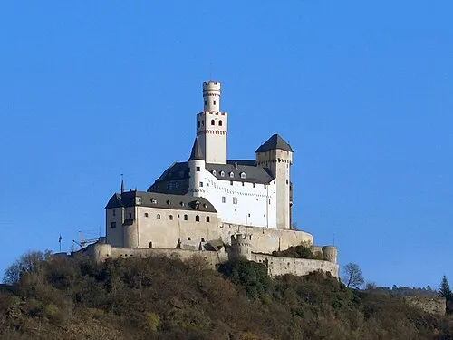 Marksburg Historic site, Braubach4 km SE
-
Lahn River, Germany1.9 km W
-
Liedches-Berg Mountain, Koblenz2.4 km N
-
Schloss Stolzenfels Historic site, Koblenz2.3 km W
-
Stolzenfels Pfarrkirche St. Menas Attraction, Koblenz2.3 km W
Sources & licences
Data last updated: · 2 independent sources