- Elevation
- 460 m
- above sea level
- Local time
- UTC+01:00
- Europe/Berlin · UTC+01:00
- Airports
- FRA Frankfurt Main Airport51 km
- HHN Frankfurt-Hahn Airport59 km
About Weißlerhöhe
Weißlerhöhe is a mountain. Location: Oberfischbach, Rhein-Lahn-Kreis. Elevation: 460 m. The best months to visit are June–August. The nearest airport is Frankfurt Main Airport (51 km). Nearby sights include Ringmauer and Horst.
Photos of Weißlerhöhe
-
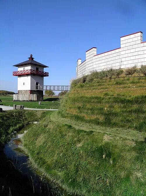
Pohl Roman Fortlet Carole Raddato from FRANKFURT, Germany · CC BY-SA 2.0

Climate of Weißlerhöhe
Best months for sightseeingBest months for sightseeing: June–August.
This month · November
A cold month
Day 6° · Night 1° · Rain 69 mm
- Hottest month
- July (day 22°)
- Coldest month
- February (night -3°)
- Wettest month
- December (76 mm)
- Driest month
- February (54 mm)
Bars: average monthly low and high temperature. Below: precipitation. Monthly averages for 1970–2000 at about 18 km resolution, adjusted for elevation. Highlighted months are mild and relatively dry. Source: WorldClim 2.1 (CC BY 4.0).
Show values as a table
| Month | Jan | Feb | Mar | Apr | May | Jun | Jul | Aug | Sep | Oct | Nov | Dec |
|---|---|---|---|---|---|---|---|---|---|---|---|---|
| Average high (°C) | 2° | 3° | 7° | 12° | 17° | 19° | 22° | 22° | 17° | 11° | 6° | 3° |
| Average low (°C) | -3° | -3° | 0° | 2° | 6° | 10° | 11° | 11° | 8° | 4° | 1° | -1° |
| Precipitation (mm) | 64 | 54 | 64 | 55 | 67 | 72 | 75 | 56 | 63 | 67 | 69 | 76 |
How to get to Weißlerhöhe
The nearest airport is Frankfurt Main Airport (FRA), 51 km to the southeast as the crow flies. The nearest large city is Koblenz, 28 km to the northwest.
Airports
- Frankfurt Main Airport (FRA) Frankfurt am Main 51 kmsoutheast
- Frankfurt-Hahn Airport (HHN) Frankfurt am Main (Lautzenhausen) 59 kmsouthwest
- Cologne Bonn Airport (CGN) Köln (Cologne) 88 kmnorthwest
Nearby large cities
- Koblenz Population: 107.3K 28 kmnorthwest
- Wiesbaden Population: 288.8K 29 kmsoutheast
- Mainz Population: 222.9K 39 kmsoutheast
- Frankfurt am Main Population: 650K 56 kmeast
- Offenbach Population: 119.2K 62 kmeast
Straight-line distances; road distances are longer. Airport data: OurAirports.
Day trips from Weißlerhöhe
Within 100 km: 829 historic and cultural sites, 4,300 natural sites, 889 lakes, rivers and coasts.
0–25 km448 places
- Aar River 14 kmN
- Höhr Mountain 21 kmNW
- Zorner Kopf Mountain 12 kmS
- Ziegenkopf Mountain 14 kmS
25–60 km1,719 places
- Urbach River 41 kmNW
- Rüdesheimer Aue Island 31 kmS
- Petersaue Island 35 kmSE
- Mariannenaue Island 29 kmS
60–100 km3,851 places
- Weibe River 70 kmN
- Ohe River 80 kmNE
- Modau River 62 kmSE
- Lumda River 70 kmNE
Straight-line distances.
Nearest towns and villages
-
Oberfischbach Village, Oberfischbach1.7 km E
-
Katzenelnbogen Village, Katzenelnbogen3.4 km NE
-
Rettert Village, Rettert2.5 km S
-
Mittelfischbach Village, Rhein-Lahn-Kreis2 km E
-
Mittelfischbach Village, Mittelfischbach2.1 km E
-
Rettert Village, Rhein-Lahn-Kreis2.5 km S
Nearby attractions & nature
Everything nearby-
Ringmauer Mountain, Oberfischbach1.4 km SW
-
Horst Mountain, Katzenelnbogen2.2 km NE
-
Kahlberg Mountain, Klingelbach4 km NE
-
Pfarrhofenberg Mountain, Miehlen4.9 km SW
-
Hahnkopf Mountain, Heidenrod5.2 km SE
-
Grauer Kopf Mountain, Heidenrod4.8 km S
-
Weißer Stein Mountain, Singhofen5.8 km W
-
Steinkopf Mountain, Katzenelnbogen6.4 km NE
Sources & licences
Data last updated: · 2 independent sources