Münchweiler an der Rodalb
Located in Südwestpfalz, Rhineland-Palatinate Coordinates: 49°13′00″ N 7°42′00″ E
- Population
- 2,739
- 2.7K
- Elevation
- 270 m
- above sea level
- Local time
- UTC+01:00
- Europe/Berlin · UTC+01:00
- Places inside
- 10
- listed under Münchweiler an der Rodalb
- Airports
- SCN Saarbrücken Airport43 km
- FKB Karlsruhe Baden-Baden Airport56 km
About Münchweiler an der Rodalb
Münchweiler an der Rodalb is a village. Location: Südwestpfalz, Rhineland-Palatinate. Population: 2,739. Elevation: 270 m. The best months to visit are June–August. The nearest airport is Saarbrücken Airport (43 km). Nearby sights include Lams Bach and Riegelbrunner Eck.
Photos of Münchweiler an der Rodalb
-
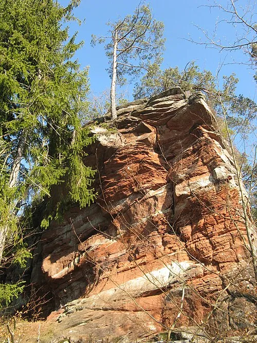
Handschuhkopf Reise-Line · CC BY-SA 3.0

Climate of Münchweiler an der Rodalb
Best months for sightseeingBest months for sightseeing: June–August.
This month · November
A cold month
Day 8° · Night 2° · Rain 77 mm
- Hottest month
- July (day 23°)
- Coldest month
- February (night -1°)
- Wettest month
- December (88 mm)
- Driest month
- April (57 mm)
Bars: average monthly low and high temperature. Below: precipitation. Monthly averages for 1970–2000 at about 18 km resolution, adjusted for elevation. Highlighted months are mild and relatively dry. Source: WorldClim 2.1 (CC BY 4.0).
Show values as a table
| Month | Jan | Feb | Mar | Apr | May | Jun | Jul | Aug | Sep | Oct | Nov | Dec |
|---|---|---|---|---|---|---|---|---|---|---|---|---|
| Average high (°C) | 4° | 5° | 9° | 13° | 18° | 21° | 23° | 23° | 19° | 13° | 8° | 5° |
| Average low (°C) | -1° | -1° | 1° | 4° | 8° | 11° | 13° | 12° | 9° | 6° | 2° | 0° |
| Precipitation (mm) | 68 | 64 | 65 | 57 | 79 | 79 | 73 | 63 | 64 | 77 | 77 | 88 |
How to get to Münchweiler an der Rodalb
The nearest airport is Saarbrücken Airport (SCN), 43 km to the west as the crow flies. For international flights: Karlsruhe Baden-Baden Airport (FKB) (56 km). The nearest large city is Saarbrücken, 50 km to the west.
Airports
- Saarbrücken Airport (SCN) Saarbrücken 43 kmwest
- Karlsruhe Baden-Baden Airport (FKB) Rheinmünster 56 kmsoutheast
- Mannheim-City Airport (MHG) Mannheim 66 kmnortheast
Nearby large cities
- Saarbrücken Population: 183K 50 kmwest
- Karlsruhe Population: 283.8K 56 kmsoutheast
- Ludwigshafen am Rhein Population: 163.2K 62 kmnortheast
- Mannheim Population: 308K 63 kmnortheast
- Strasbourg Population: 274.8K 70 kmsouth
Straight-line distances; road distances are longer. Airport data: OurAirports.
Day trips from Münchweiler an der Rodalb
Within 100 km: 720 historic and cultural sites, 3,235 natural sites, 711 lakes, rivers and coasts.
0–25 km632 places
- Gelterswoog Lake 20 kmN
- Zwieselkopf Mountain 15 kmE
- Zündelsberg Mountain 17 kmS
- Zöllerberg Mountain 15 kmSE
25–60 km1,233 places
- Insel Flotzgrün Island 55 kmE
- Otterstadter Altrhein Lake 60 kmE
- Altrhein Kleiner Bodensee Lake 50 kmE
- Angelhofer Altrhein Lake 59 kmE
60–100 km2,801 places
- Unditz River 87 kmS
- Elsenz River 82 kmE
- Rench River 63 kmS
- Modau River 86 kmNE
Straight-line distances.
Places in Münchweiler an der Rodalb
10 placesBar: population relative to the most populous place in this list.
Mountains & nature9
- Bauwalder Kopf · Mountain
- Große Schieß · Mountain
- Imsbacher Eck · Mountain
- Kleine Schieß · Mountain
- Kurzelberg · Mountain
- Langenberg · Mountain
- Langenberg · Mountain
- Röderkopf · Mountain
- Rotenstein · Mountain
Nearby attractions & nature
Everything nearby-
Lams Bach River, Rhineland-Palatinate0.7 km SW
-
Riegelbrunner Eck Mountain, Merzalben2.3 km N
-
Ofenberg Mountain, Merzalben2.9 km N
-
Imsenkopf Mountain, Merzalben2.6 km NE
-
Schnepfenberg Mountain, Ruppertsweiler2.9 km S
-
Herrenwald Natural site, Rhineland-Palatinate2.3 km E
Sources & licences
Data last updated: