Flemmingen
Located in Naumburg (Saale), Burgenlandkreis Coordinates: 51°07′54″ N 11°46′00″ E

- Elevation
- 229 m
- above sea level
- Local time
- UTC+01:00
- Europe/Berlin · UTC+01:00
- Airports
- LEJ Leipzig/Halle Airport46 km
- ERF Erfurt-Weimar Airport59 km
About Flemmingen
Flemmingen is a village. Location: Naumburg (Saale), Burgenlandkreis. Elevation: 229 m.
The village of Flemmingen is one of the eleven components of the cultural landscape Naumburg Cathedral and the High Medieval Cultural Landscape of the Rivers Saale and Unstrut that has been proposed by the Federal Republic of Germany for inscription in the List of World Heritage.
Source: Wikipedia · CC BY-SA 4.0
Photos of Flemmingen
-
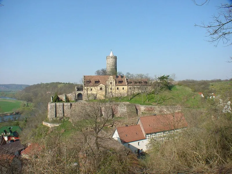
Burg Schönburg Mewes at German Wikipedia · Public domain

Climate of Flemmingen
Best months for sightseeingBest months for sightseeing: June–September.
This month · November
A cold month
Day 7° · Night 1° · Rain 47 mm
- Hottest month
- August (day 24°)
- Coldest month
- January (night -2°)
- Wettest month
- July (73 mm)
- Driest month
- January (33 mm)
Bars: average monthly low and high temperature. Below: precipitation. Monthly averages for 1970–2000 at about 18 km resolution, adjusted for elevation. Highlighted months are mild and relatively dry. Source: WorldClim 2.1 (CC BY 4.0).
Show values as a table
| Month | Jan | Feb | Mar | Apr | May | Jun | Jul | Aug | Sep | Oct | Nov | Dec |
|---|---|---|---|---|---|---|---|---|---|---|---|---|
| Average high (°C) | 3° | 4° | 9° | 13° | 18° | 21° | 23° | 24° | 19° | 14° | 7° | 4° |
| Average low (°C) | -2° | -2° | 1° | 3° | 7° | 11° | 12° | 12° | 9° | 5° | 1° | -1° |
| Precipitation (mm) | 33 | 34 | 44 | 41 | 61 | 62 | 73 | 64 | 47 | 38 | 47 | 45 |
Other places to visit in this season: June July August September
How to get to Flemmingen
The nearest airport is Leipzig/Halle Airport (LEJ), 46 km to the northeast as the crow flies. The nearest large city is Jena, 26 km to the southwest.
Airports
- Leipzig/Halle Airport (LEJ) Schkeuditz 46 kmnortheast
- Erfurt-Weimar Airport (ERF) Erfurt 59 kmwest
- Karlovy Vary Airport (KLV) Karlovy Vary 131 kmsoutheast
Nearby large cities
- Jena Population: 104.7K 26 kmsouthwest
- Gera Population: 104.7K 36 kmsoutheast
- Halle Population: 237.9K 42 kmnorth
- Leipzig Population: 505K 48 kmnortheast
- Erfurt Population: 218.8K 54 kmwest
Straight-line distances; road distances are longer. Airport data: OurAirports.
Day trips from Flemmingen
Within 100 km: 563 historic and cultural sites, 3,090 natural sites, 733 lakes, rivers and coasts.
0–25 km176 places
- Zietschkuppe Mountain 19 kmS
- Volksberg Mountain 12 kmW
- Unterer Mohnberg Mountain 24 kmS
- Sausberg Mountain 19 kmNW
25–60 km1,083 places
- Buchenwald concentration camp Historic site 38 kmW
- Sprotte River 51 kmSE
- Roda River 30 kmSW
- Roda River 32 kmS
60–100 km3,127 places
- Ehle River 88 kmN
- Bere River 84 kmNW
- Tietal Lake 94 kmN
- Wüster Teich Lake 79 kmS
Straight-line distances.
Nearby attractions & nature
Everything nearby-
Schulpforte, Klosterkirche Attraction, Naumburg (Saale)1.5 km NW
-
Buchholz Natural site, Saxony-Anhalt2.3 km E
-
Forst Pforta Natural site, Saxony-Anhalt2.9 km SW
-
Bad Koesen, Lutherkirche Attraction, Naumburg (Saale)3.5 km W
-
Naumburg, Dom St. Peter und Paul Attraction, Naumburg (Saale)3.7 km NE
-
Langer Berg Mountain, Naumburg (Saale)4.9 km NW
Other cities and towns in Naumburg (Saale)


Sources & licences
Data last updated: · 2 independent sources