Kreis Herzogtum Lauenburg
Located in Schleswig-Holstein, Germany Coordinates: 53°36′27″ N 10°37′30″ E
- Population
- 206,235
- 206.2K
- Elevation
- 35 m
- above sea level
- Local time
- UTC+01:00
- Europe/Berlin · UTC+01:00
- Places inside
- 178
- listed under Kreis Herzogtum Lauenburg
- Airports
- LBC Lübeck Blankensee Airport23 km
- HAM Hamburg Helmut Schmidt Airport42 km
About Kreis Herzogtum Lauenburg
Kreis Herzogtum Lauenburg is a municipality. Location: Schleswig-Holstein, Germany. Population: 206,235. Elevation: 35 m. The best months to visit are June–August. The nearest airport is Lübeck Blankensee Airport (23 km). Nearby sights include Bälauer Zuschlag and Grambeker Holz.
Photos of Kreis Herzogtum Lauenburg
-
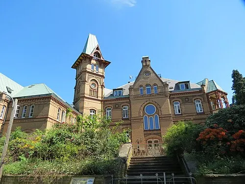
Schloß Seedorf Engeser · CC BY-SA 3.0

Climate of Kreis Herzogtum Lauenburg
Best months for sightseeingBest months for sightseeing: June–August.
This month · November
A cold month
Day 7° · Night 2° · Rain 66 mm
- Hottest month
- August (day 22°)
- Coldest month
- January (night -2°)
- Wettest month
- July (73 mm)
- Driest month
- February (46 mm)
Bars: average monthly low and high temperature. Below: precipitation. Monthly averages for 1970–2000 at about 18 km resolution, adjusted for elevation. Highlighted months are mild and relatively dry. Source: WorldClim 2.1 (CC BY 4.0).
Show values as a table
| Month | Jan | Feb | Mar | Apr | May | Jun | Jul | Aug | Sep | Oct | Nov | Dec |
|---|---|---|---|---|---|---|---|---|---|---|---|---|
| Average high (°C) | 3° | 4° | 7° | 12° | 17° | 20° | 22° | 22° | 18° | 13° | 7° | 4° |
| Average low (°C) | -2° | -2° | 0° | 3° | 7° | 10° | 12° | 12° | 9° | 5° | 2° | 0° |
| Precipitation (mm) | 62 | 46 | 56 | 47 | 50 | 67 | 73 | 73 | 62 | 59 | 66 | 70 |
How to get to Kreis Herzogtum Lauenburg
The nearest airport is Lübeck Blankensee Airport (LBC), 23 km to the north as the crow flies. For international flights: Hamburg Helmut Schmidt Airport (HAM) (42 km). The nearest large city is Lübeck, 29 km to the north.
Airports
- Lübeck Blankensee Airport (LBC) Lübeck 23 kmnorth
- Hamburg Helmut Schmidt Airport (HAM) Hamburg 42 kmwest
- Rostock-Laage Airport (RLG) Laage 114 kmeast
Nearby large cities
- Lübeck Population: 212.2K 29 kmnorth
- Kiel Population: 252.7K 86 kmnorth
- Rostock Population: 198.3K 113 kmnortheast
- Wolfsburg Population: 123.1K 132 kmsouth
- Bremen Population: 546.5K 135 kmsouthwest
Straight-line distances; road distances are longer. Airport data: OurAirports.
Day trips from Kreis Herzogtum Lauenburg
Within 100 km: 388 historic and cultural sites, 3,281 natural sites, 1,287 lakes, rivers and coasts.
0–25 km572 places
- Viertbusch Natural site 23 kmSW
- Fischwerder Island 19 kmNE
- Kleiner Werder Island 22 kmE
- Großer Werder Island 21 kmE
25–60 km1,459 places
- Ziegelwerder Island 57 kmE
- Hundestrand Beach 49 kmN
- Strand Rosenhagen Beach 45 kmNE
- Hundestrand 1 Beach 48 kmNE
60–100 km2,925 places
- Poel Island Island 68 kmNE
- Spock River 74 kmNW
- Aubek River 77 kmNW
- Köppernitz River 63 kmNE
Straight-line distances.
Kreis Herzogtum Lauenburg and similar cities
Side by side with cities of similar size in the same country: population, elevation and climate.
| Measure | Kreis Herzogtum Lauenburg | Lübeck | Hagen | Rostock |
|---|---|---|---|---|
| Population | 206.2K | 212.2K | 199K | 198.3K |
| Elevation | 35 m | 16 m | 111 m | 18 m |
| Summer day (hottest month) | 22° | 22° | 23° | 22° |
| Winter night (coldest month) | -2° | -2° | -1° | -2° |
| Annual rainfall | 731 mm | 674 mm | 980 mm | 596 mm |
| Best months | Jun–Aug | Jun–Aug | Jun–Aug | Jun–Aug |
| Distance | — | 29 km | 329 km | 113 km |
Climate values are 1970–2000 monthly averages; straight-line distance.
Places in Kreis Herzogtum Lauenburg
178 places- 61 Duvensee 564
- 62 Groß Schenkenberg 562
- 63 Talkau 557
- 64 Hamfelde 555
- 65 Roseburg 540
- 66 Möhnsen 539
- 67 Hohenhorn 522
- 68 Pogeez 520
- 69 Schretstaken 505
- 70 Hollenbek 476
- 71 Schulendorf 472
- 72 Lankau 456
- 73 Sahms 454
- 74 Basthorst 450
- 75 Einhaus 444
- 76 Sierksrade 422
- 77 Behlendorf 395
- 78 Fitzen 393
- 79 Stubben 388
- 80 Fuhlenhagen 374
- 81 Poggensee 372
- 82 Krüzen 365
- 83 Grabau 358
- 84 Dalldorf 348
- 85 Sirksfelde 348
- 86 Kühsen 348
- 87 Woltersdorf 344
- 88 Tramm 343
- 89 Bröthen 320
- 90 Harmsdorf 311
- 91 Borstorf 306
- 92 Lüchow 306
- 93 Kittlitz 295
- 94 Köthel (Lauenburg) 295
- 95 Siebeneichen 295
- 96 Ritzerau 293
- 97 Grinau 278
- 98 Lanze 273
- 99 Horst 269
- 100 Grove 258
- 101 Klein Zecher 243
- 102 Göldenitz 243
- 103 Buchholz 237
- 104 Walksfelde 227
- 105 Bälau 224
- 106 Wiershop 219
- 107 Kankelau 217
- 108 Mühlenrade 215
- 109 Kulpin 214
- 110 Wangelau 210
- 111 Groß Boden 204
- 112 Hornbek 202
- 113 Havekost 199
- 114 Groß Pampau 187
- 115 Niendorf bei Berkenthin 184
- 116 Langenlehsten 184
- 117 Juliusburg 180
- 118 Giesensdorf 170
- 119 Worth 169
- 120 Schürensöhlen 164
Bar: population relative to the most populous place in this list.
Nearby attractions & nature
Everything nearby-
Bälauer Zuschlag Natural site, Schleswig-Holstein2.5 km W
-
Grambeker Holz Natural site, Schleswig-Holstein3.9 km E
-
Lehmberg Natural site, Schleswig-Holstein4.2 km W
-
Dorn Natural site, Schleswig-Holstein4.4 km W
-
Möllner See Lake, Schleswig-Holstein4.3 km NE
-
Mühlenbach River, Schleswig-Holstein4.4 km NE
-
Stubben Natural site, Schleswig-Holstein5 km SW
-
Steinau River, Schleswig-Holstein4.8 km N
Sources & licences
Data last updated: