Kreis Herzogtum Lauenburg
Located in Schleswig-Holstein, Germany Coordinates: 53°36′27″ N 10°37′30″ E
- Population
- 206,235
- 206.2K
- Elevation
- 35 m
- above sea level
- Local time
- UTC+01:00
- Europe/Berlin · UTC+01:00
- Places inside
- 178
- listed under Kreis Herzogtum Lauenburg
- Airports
- LBC Lübeck Blankensee Airport23 km
- HAM Hamburg Helmut Schmidt Airport42 km
About Kreis Herzogtum Lauenburg
Kreis Herzogtum Lauenburg is a municipality. Location: Schleswig-Holstein, Germany. Population: 206,235. Elevation: 35 m. The best months to visit are June–August. The nearest airport is Lübeck Blankensee Airport (23 km). Nearby sights include Bälauer Zuschlag and Grambeker Holz.
Photos of Kreis Herzogtum Lauenburg
-
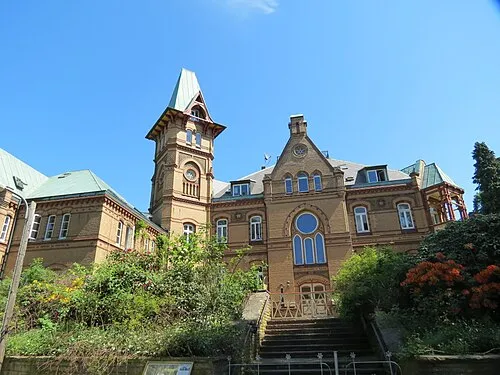
Schloß Seedorf Engeser · CC BY-SA 3.0

Climate of Kreis Herzogtum Lauenburg
Best months for sightseeingBest months for sightseeing: June–August.
This month · November
A cold month
Day 7° · Night 2° · Rain 66 mm
- Hottest month
- August (day 22°)
- Coldest month
- January (night -2°)
- Wettest month
- July (73 mm)
- Driest month
- February (46 mm)
Bars: average monthly low and high temperature. Below: precipitation. Monthly averages for 1970–2000 at about 18 km resolution, adjusted for elevation. Highlighted months are mild and relatively dry. Source: WorldClim 2.1 (CC BY 4.0).
Show values as a table
| Month | Jan | Feb | Mar | Apr | May | Jun | Jul | Aug | Sep | Oct | Nov | Dec |
|---|---|---|---|---|---|---|---|---|---|---|---|---|
| Average high (°C) | 3° | 4° | 7° | 12° | 17° | 20° | 22° | 22° | 18° | 13° | 7° | 4° |
| Average low (°C) | -2° | -2° | 0° | 3° | 7° | 10° | 12° | 12° | 9° | 5° | 2° | 0° |
| Precipitation (mm) | 62 | 46 | 56 | 47 | 50 | 67 | 73 | 73 | 62 | 59 | 66 | 70 |
How to get to Kreis Herzogtum Lauenburg
The nearest airport is Lübeck Blankensee Airport (LBC), 23 km to the north as the crow flies. For international flights: Hamburg Helmut Schmidt Airport (HAM) (42 km). The nearest large city is Lübeck, 29 km to the north.
Airports
- Lübeck Blankensee Airport (LBC) Lübeck 23 kmnorth
- Hamburg Helmut Schmidt Airport (HAM) Hamburg 42 kmwest
- Rostock-Laage Airport (RLG) Laage 114 kmeast
Nearby large cities
- Lübeck Population: 212.2K 29 kmnorth
- Kiel Population: 252.7K 86 kmnorth
- Rostock Population: 198.3K 113 kmnortheast
- Wolfsburg Population: 123.1K 132 kmsouth
- Bremen Population: 546.5K 135 kmsouthwest
Straight-line distances; road distances are longer. Airport data: OurAirports.
Day trips from Kreis Herzogtum Lauenburg
Within 100 km: 388 historic and cultural sites, 3,281 natural sites, 1,287 lakes, rivers and coasts.
0–25 km572 places
- Viertbusch Natural site 23 kmSW
- Fischwerder Island 19 kmNE
- Kleiner Werder Island 22 kmE
- Großer Werder Island 21 kmE
25–60 km1,459 places
- Ziegelwerder Island 57 kmE
- Hundestrand Beach 49 kmN
- Strand Rosenhagen Beach 45 kmNE
- Hundestrand 1 Beach 48 kmNE
60–100 km2,925 places
- Poel Island Island 68 kmNE
- Spock River 74 kmNW
- Aubek River 77 kmNW
- Köppernitz River 63 kmNE
Straight-line distances.
Kreis Herzogtum Lauenburg and similar cities
Side by side with cities of similar size in the same country: population, elevation and climate.
| Measure | Kreis Herzogtum Lauenburg | Lübeck | Hagen | Rostock |
|---|---|---|---|---|
| Population | 206.2K | 212.2K | 199K | 198.3K |
| Elevation | 35 m | 16 m | 111 m | 18 m |
| Summer day (hottest month) | 22° | 22° | 23° | 22° |
| Winter night (coldest month) | -2° | -2° | -1° | -2° |
| Annual rainfall | 731 mm | 674 mm | 980 mm | 596 mm |
| Best months | Jun–Aug | Jun–Aug | Jun–Aug | Jun–Aug |
| Distance | — | 29 km | 329 km | 113 km |
Climate values are 1970–2000 monthly averages; straight-line distance.
Places in Kreis Herzogtum Lauenburg
178 places- 121 Krukow 162
- 122 Dahmker 161
- 123 Düchelsdorf 161
- 124 Brunsmark 157
- 125 Buchhorst 151
- 126 Mechow 135
- 127 Besenthal 98
- 128 Groß Disnack 84
- 129 Albsfelde 76
- 130 Göttin 71
- 131 Römnitz 60
- 132 Fredeburg 44
Bar: population relative to the most populous place in this list.
Mountains & nature44
- Auberg · Mountain
- Benekenriede · Natural site
- Bornberg · Natural site
- Braken · Natural site
- Brunsrade · Natural site
- Buschhege · Natural site
- Buschhege Ost · Natural site
- Buschhege West · Natural site
- Dassendorfer Horst · Natural site
- Fahrenhorst · Natural site
- Flachsmoor · Natural site
- Fortwinkel · Natural site
- Großer Braak · Natural site
- Groß Ochsenbek · Natural site
- Groß Viert · Natural site
- Hasenbekshorst · Natural site
- Havekoster Wohld · Natural site
- Heidkamp · Natural site
- Hohehorst · Natural site
- Hohenberg · Mountain
- Kämpen · Natural site
- Kämpenhege · Natural site
- Kasseburger Horst · Natural site
- Klein Ochsenbek · Natural site
- Klein Viert · Natural site
- Knopshörn · Natural site
- Krämel · Natural site
- Kreienhörn · Natural site
- Krogbusch · Natural site
- Kröppelshagener Busch · Natural site
- Kupferberg · Natural site
- Lohe · Natural site
- Moorigen Ort · Natural site
- Neukoppel · Natural site
- Saugarten · Natural site
- Schäferholz · Natural site
- Schwarze Riede · Natural site
- Seege · Natural site
- Sigrimsberg · Natural site
- Stangenteichshorst · Natural site
- Stemmenkamp · Natural site
- Strange · Natural site
- Tiefensohl · Natural site
- Witzhaverviert · Natural site
Lakes, rivers & coasts1
- Süsserbek · River
Heritage & sights1
- Goldammers Grab · Historic site
Nearby attractions & nature
Everything nearby-
Bälauer Zuschlag Natural site, Schleswig-Holstein2.5 km W
-
Grambeker Holz Natural site, Schleswig-Holstein3.9 km E
-
Lehmberg Natural site, Schleswig-Holstein4.2 km W
-
Dorn Natural site, Schleswig-Holstein4.4 km W
-
Möllner See Lake, Schleswig-Holstein4.3 km NE
-
Mühlenbach River, Schleswig-Holstein4.4 km NE
-
Stubben Natural site, Schleswig-Holstein5 km SW
-
Steinau River, Schleswig-Holstein4.8 km N
Sources & licences
Data last updated: