Mantoudi-Limni-Agia Anna
Located in Euboea, Central Greece Coordinates: 38°48′14″ N 23°25′14″ E
- Population
- 13,673
- 13.7K
- Elevation
- 181 m
- above sea level
- Local time
- UTC+02:00
- Europe/Athens · UTC+02:00
- Places inside
- 22
- listed under Mantoudi-Limni-Agia Anna
- Airports
- JSI Skiathos Island National Airport42 km
- VOL Nea Anchialos National Airport71 km
About Mantoudi-Limni-Agia Anna
Mantoudi-Limni-Agia Anna is a municipality. Location: Euboea, Central Greece. Population: 13,673. Elevation: 181 m. The best months to visit are May, September–October. The nearest airport is Skiathos Island National Airport (42 km).
Photos of Mantoudi-Limni-Agia Anna
-
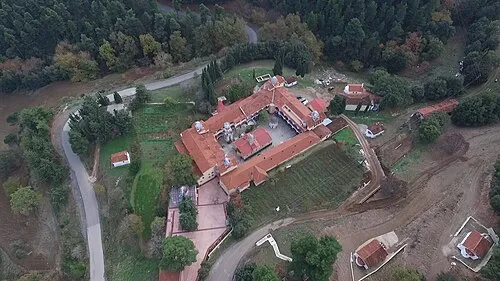
Moni Osiou David Glinard · CC BY-SA 4.0

Climate of Mantoudi-Limni-Agia Anna
Best months for sightseeingBest months for sightseeing: May, September–October.
This month · November
Outside the best season
Day 16° · Night 9° · Rain 66 mm
- Hottest month
- July (day 30°)
- Coldest month
- January (night 5°)
- Wettest month
- December (85 mm)
- Driest month
- July (10 mm)
Bars: average monthly low and high temperature. Below: precipitation. Monthly averages for 1970–2000 at about 18 km resolution, adjusted for elevation. Highlighted months are mild and relatively dry. Source: WorldClim 2.1 (CC BY 4.0).
Show values as a table
| Month | Jan | Feb | Mar | Apr | May | Jun | Jul | Aug | Sep | Oct | Nov | Dec |
|---|---|---|---|---|---|---|---|---|---|---|---|---|
| Average high (°C) | 11° | 11° | 14° | 18° | 23° | 28° | 30° | 30° | 26° | 21° | 16° | 12° |
| Average low (°C) | 5° | 5° | 7° | 10° | 14° | 18° | 20° | 20° | 17° | 13° | 9° | 6° |
| Precipitation (mm) | 67 | 63 | 60 | 36 | 27 | 17 | 10 | 13 | 23 | 62 | 66 | 85 |
How to get to Mantoudi-Limni-Agia Anna
The nearest airport is Skiathos Island National Airport (JSI), 42 km to the north as the crow flies. For international flights: Athens Eleftherios Venizelos International Airport (ATH) (107 km). The nearest large city is Athens, 95 km to the south.
Airports
- Skiathos Island National Airport (JSI) Skiathos 42 kmnorth
- Nea Anchialos National Airport (VOL) Nea Anchialos 71 kmnorthwest
- Athens Eleftherios Venizelos International Airport (ATH) Spata-Artemida 107 kmsoutheast
Nearby large cities
- Athens Population: 664K 95 kmsouth
- Piraeus Population: 163.7K 98 kmsouth
- Çanakkale Population: 143.6K 298 kmnortheast
- Çiğli Population: 214.1K 320 kmeast
- Konak Population: 332.3K 324 kmeast
Straight-line distances; road distances are longer. Airport data: OurAirports.
Day trips from Mantoudi-Limni-Agia Anna
Within 100 km: 27 historic and cultural sites, 2 natural sites, 19 lakes, rivers and coasts.
0–25 km1 place
- Moni Osiou David Attraction 13 kmW
25–60 km8 places
- Ákra Dhrépanon Natural site 58 kmW
- Vrolimnos Beach Beach 37 kmN
- Archaeological Museum of Thebes Museum 54 kmS
- Anthedon Historic site 34 kmS
60–100 km39 places
- Euboea Island 61 kmSE
- Pnyx Mountain 96 kmS
- Moní Agíou Ierothéou Attraction 89 kmS
- Ierá Moní Odigítrias Attraction 70 kmW
Straight-line distances.
Places in Mantoudi-Limni-Agia Anna
22 places- 1 Mantoúdi 2.2K
- 2 Límni 2.1K
- 3 Roviés 1.2K
- 4 Prokópi 1.1K
- 5 Agía Ánna 823
- 6 Kourkouloí 682
- 7 Kechriés 501
- 8 Spathári 340
- 9 Vlachiá 317
- 10 Farákla 286
- 11 Metóchi 284
- 12 Myrtiás 284
- 13 Kalývia 242
- 14 Dafnoússa 233
- 15 Amélantes 180
- 16 Troúpi 158
- 17 Drymóna 142
- 18 Damiá 107
- 19 Stráfoi 96
- 20 Krýa Vrýsi 53
- 21 Moni Osiou David 18
- 22 Achlαdopotamo 16
Bar: population relative to the most populous place in this list.
Other cities and towns in Euboea
-
Dirfys-Messapia Municipality, Euboea33 km SE
-
Chalcis Municipality, Euboea41 km S
-
 Nea Artaki Town, Chalcis37 km SE
-
Kymi-Aliveri Municipality, Euboea67 km SE
-
Eretria Municipality, Euboea55 km SE
-
Karystos Municipality, Euboea114 km SE
Sources & licences
Data last updated: