- Population
- 852
- 852
- Elevation
- 243 m
- above sea level
- Local time
- UTC+02:00
- Europe/Athens · UTC+02:00
- Airports
- HER Heraklion International Nikos Kazantzakis Airport41 km
- CHQ Chania International Airport83 km
About Galiá
Galiá is a village. Location: Faistos, Heraklion Regional Unit. Population: 852. Elevation: 243 m. The best months to visit are April–May, September–October. The nearest airport is Heraklion International Nikos Kazantzakis Airport (41 km). Nearby sights include Vouloumenou and Nida Plateau.
Climate of Galiá
Best months for sightseeingBest months for sightseeing: April–May, September–October.
This month · November
Outside the best season
Day 19° · Night 12° · Rain 82 mm
- Hottest month
- July (day 30°)
- Coldest month
- February (night 7°)
- Wettest month
- January (143 mm)
- Driest month
- August (1 mm)
Bars: average monthly low and high temperature. Below: precipitation. Monthly averages for 1970–2000 at about 18 km resolution, adjusted for elevation. Highlighted months are mild and relatively dry. Source: WorldClim 2.1 (CC BY 4.0).
Show values as a table
| Month | Jan | Feb | Mar | Apr | May | Jun | Jul | Aug | Sep | Oct | Nov | Dec |
|---|---|---|---|---|---|---|---|---|---|---|---|---|
| Average high (°C) | 14° | 14° | 16° | 20° | 24° | 29° | 30° | 30° | 28° | 24° | 19° | 16° |
| Average low (°C) | 8° | 7° | 9° | 11° | 15° | 19° | 21° | 21° | 19° | 15° | 12° | 9° |
| Precipitation (mm) | 143 | 108 | 87 | 37 | 19 | 6 | 3 | 1 | 19 | 73 | 82 | 122 |
Other places to visit in this season: April May September October
How to get to Galiá
The nearest airport is Heraklion International Nikos Kazantzakis Airport (HER), 41 km to the northeast as the crow flies. The nearest large city is Piraeus, 336 km to the north.
Airports
- Heraklion International Nikos Kazantzakis Airport (HER) Heraklion 41 kmnortheast
- Chania International Airport (CHQ) Souda 83 kmnorthwest
- Sitia Airport (JSH) Crete Island 113 kmeast
Nearby large cities
- Piraeus Population: 163.7K 336 kmnorth
- Athens Population: 664K 338 kmnorth
Straight-line distances; road distances are longer. Airport data: OurAirports.
Day trips from Galiá
Within 100 km: 10 historic and cultural sites, 13 natural sites, 8 lakes, rivers and coasts.
0–25 km2 places
- Vouloumenou Mountain 17 kmN
- Nida Plateau Natural site 14 kmN
25–60 km24 places
- Arkadi Monastery Attraction 34 kmNW
- Moni Ayiou Panteleimon Attraction 32 kmN
- Kolympoi Mountain 55 kmE
- Bali Beach Beach 38 kmN
60–100 km5 places
- Metamórfosi Sotíros Attraction 76 kmNW
- Moni Agiou Eleftheriou Attraction 90 kmNW
- Spinalonga Island 83 kmE
- Paralia Platania Beach 99 kmNW
Straight-line distances.
Nearby attractions & nature
Everything nearby-
Vouloumenou Mountain, Faistos17 km N
-
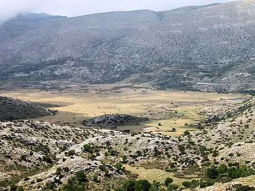 Nida Plateau Natural site, Crete14 km N
Sources & licences
Data last updated: