Perrystreet Cross Roads
Located in County Kildare, Leinster Coordinates: 53°06′54″ N 6°36′46″ W
- Elevation
- 161 m
- above sea level
- Local time
- UTC+00:00
- Europe/Dublin · UTC+00:00
- Airports
- DUB Dublin Airport42 km
- SNN Shannon Airport162 km
About Perrystreet Cross Roads
Perrystreet Cross Roads is a village. Location: County Kildare, Leinster. Elevation: 161 m. The best months to visit are June–September. The nearest airport is Dublin Airport (42 km). Nearby sights include Ballymore Bridge and Pollaphuca Waterfall.
Photos of Perrystreet Cross Roads
-
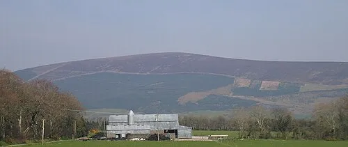
Church Mountain Sarah777 at English Wikipedia · Public domain

Climate of Perrystreet Cross Roads
Best months for sightseeingBest months for sightseeing: June–September.
This month · November
A cold month
Day 10° · Night 4° · Rain 94 mm
- Hottest month
- July (day 19°)
- Coldest month
- January (night 2°)
- Wettest month
- December (110 mm)
- Driest month
- June (65 mm)
Bars: average monthly low and high temperature. Below: precipitation. Monthly averages for 1970–2000 at about 18 km resolution, adjusted for elevation. Highlighted months are mild and relatively dry. Source: WorldClim 2.1 (CC BY 4.0).
Show values as a table
| Month | Jan | Feb | Mar | Apr | May | Jun | Jul | Aug | Sep | Oct | Nov | Dec |
|---|---|---|---|---|---|---|---|---|---|---|---|---|
| Average high (°C) | 8° | 8° | 9° | 11° | 14° | 17° | 19° | 18° | 16° | 13° | 10° | 8° |
| Average low (°C) | 2° | 2° | 3° | 4° | 6° | 9° | 11° | 11° | 9° | 7° | 4° | 3° |
| Precipitation (mm) | 107 | 79 | 75 | 67 | 72 | 65 | 65 | 82 | 94 | 99 | 94 | 110 |
Other places to visit in this season: June July August September
How to get to Perrystreet Cross Roads
The nearest airport is Dublin Airport (DUB), 42 km to the northeast as the crow flies. The nearest large city is Dublin, 34 km to the northeast.
Airports
- Dublin Airport (DUB) Dublin 42 kmnortheast
- Shannon Airport (SNN) Shannon 162 kmwest
- Isle of Man Airport (IOM) Castletown, Rushen 170 kmnortheast
Nearby large cities
- Dublin Population: 1M 34 kmnortheast
- Limerick Population: 102.3K 144 kmwest
- Belfast Population: 348K 171 kmnorth
- Cork Population: 224K 185 kmsouthwest
- Birkenhead Population: 325.3K 242 kmeast
Straight-line distances; road distances are longer. Airport data: OurAirports.
Day trips from Perrystreet Cross Roads
Within 100 km: 333 historic and cultural sites, 511 natural sites, 382 lakes, rivers and coasts.
0–25 km186 places
- Wicklow Mountains Mountain 19 kmE
- Lough Tay Lake 23 kmE
- Rathmines and Rathgar Waterworks Lake 22 kmNE
- Pollaphuca Reservoir Lake 7 kmE
25–60 km532 places
- Sandymount Strand Beach 37 kmNE
- Portmarnock Beach Beach 47 kmNE
- North Bull Island Island 42 kmNE
- Lambay Island Island 58 kmNE
60–100 km508 places
- Rockabill Island 67 kmNE
- Pollboy Bridge Landmark 60 kmN
- Curracloe Beach Beach 83 kmS
- Skerries Islands Island 63 kmNE
Straight-line distances.
Nearby attractions & nature
Everything nearby-
Ballymore Bridge Landmark, County Kildare1.7 km N
-
Pollaphuca Waterfall Natural site, County Wicklow1.6 km E
-
Slievecorragh Mountain, County Wicklow4.4 km SE
-
Woodlands Falconry and Bird of Prey Centre. Natural site, County Wicklow4 km NE
-
Barretstown Castle Historic site, County Kildare4.4 km N
-
Morteen Bridge Landmark, County Kildare4.7 km N
Other cities and towns in County Kildare
-
 Kilcullen Village, County Kildare9 km W
-
Brannockstown Village, County Kildare5.2 km W
-
Grangemore Village, County Kildare5.4 km W
-
Bishopsland Village, County Kildare1.4 km NE
-
Bishopslane Village, County Kildare2.7 km NE
-
Boleybeg Cross Roads Village, County Kildare2.7 km W
Sources & licences
Data last updated: