Sandpits Cross Roads
Located in County Kilkenny, Leinster Coordinates: 52°21′57″ N 7°19′26″ W
- Elevation
- 28 m
- above sea level
- Local time
- UTC+00:00
- Europe/Dublin · UTC+00:00
- Airports
- ORK Cork International Airport99 km
- SNN Shannon Airport115 km
About Sandpits Cross Roads
Sandpits Cross Roads is a village. Location: County Kilkenny, Leinster. Elevation: 28 m. The best months to visit are June–August. The nearest airport is Cork International Airport (99 km). Nearby sights include Carriganog Hill and Lingaun River.
Photos of Sandpits Cross Roads
-
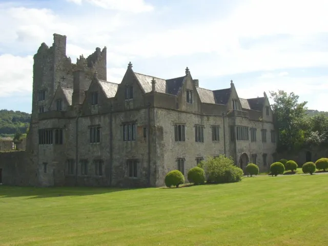
Ormonde Castle Humphrey Bolton · CC BY-SA 2.0

Climate of Sandpits Cross Roads
Best months for sightseeingBest months for sightseeing: June–August.
This month · November
A wet month
Day 11° · Night 5° · Rain 101 mm
- Hottest month
- July (day 20°)
- Coldest month
- January (night 3°)
- Wettest month
- January (111 mm)
- Driest month
- July (59 mm)
Bars: average monthly low and high temperature. Below: precipitation. Monthly averages for 1970–2000 at about 18 km resolution, adjusted for elevation. Highlighted months are mild and relatively dry. Source: WorldClim 2.1 (CC BY 4.0).
Show values as a table
| Month | Jan | Feb | Mar | Apr | May | Jun | Jul | Aug | Sep | Oct | Nov | Dec |
|---|---|---|---|---|---|---|---|---|---|---|---|---|
| Average high (°C) | 8° | 9° | 11° | 13° | 16° | 18° | 20° | 20° | 17° | 14° | 11° | 9° |
| Average low (°C) | 3° | 3° | 4° | 5° | 7° | 10° | 12° | 12° | 10° | 7° | 5° | 3° |
| Precipitation (mm) | 111 | 90 | 78 | 62 | 71 | 60 | 59 | 82 | 82 | 105 | 101 | 110 |
How to get to Sandpits Cross Roads
The nearest airport is Cork International Airport (ORK), 99 km to the southwest as the crow flies. The nearest large city is Cork, 94 km to the southwest.
Airports
- Cork International Airport (ORK) Cork 99 kmsouthwest
- Shannon Airport (SNN) Shannon 115 kmwest
- Dublin Airport (DUB) Dublin 138 kmnortheast
Nearby large cities
- Cork Population: 224K 94 kmsouthwest
- Limerick Population: 102.3K 94 kmwest
- Dublin Population: 1M 130 kmnortheast
- Swansea Population: 300.4K 247 kmeast
- Belfast Population: 348K 265 kmnorth
Straight-line distances; road distances are longer. Airport data: OurAirports.
Day trips from Sandpits Cross Roads
Within 100 km: 239 historic and cultural sites, 684 natural sites, 389 lakes, rivers and coasts.
0–25 km101 places
- Coumshingaun Lough Lake 19 kmSW
- Lough Coumfea Lake 23 kmSW
- Ballin Lough Lake 21 kmS
- Knockaderry Reservoir Lake 18 kmS
25–60 km409 places
- Saltee Islands Island 56 kmSE
- Keeragh Islands Island 45 kmSE
- Gull Island Island 28 kmS
- Sheep Island Island 28 kmS
60–100 km802 places
- Curracloe Beach Beach 66 kmE
- Saint Thomas Island Island 95 kmNW
- Rocky Island Island 89 kmSW
- Ringaskiddy Island Island 90 kmSW
Straight-line distances.
Nearby attractions & nature
Everything nearby-
Carriganog Hill Mountain, County Kilkenny4.6 km N
-
Lingaun River River, County Kilkenny3.4 km SW
-
Corbally Hill Mountain, County Kilkenny4.1 km E
-
Pil River River, County Kilkenny3.7 km S
-
Corbally Wood Natural site, County Kilkenny4.3 km E
-
Kilmacaliver Hill Mountain, County Kilkenny5.3 km NW
Other cities and towns in County Kilkenny
-
 Mooncoin Village, County Kilkenny9.9 km SE
-
Templearum Village, County Kilkenny2.8 km NE
-
Knockroe Village, County Kilkenny3.3 km W
-
Tennislee Cross Roads Village, County Kilkenny3.6 km S
-
Ashtown Village, County Kilkenny3.9 km NE
-
The Three Bridges Village, County Kilkenny4 km W
Sources & licences
Data last updated: