Tennislee Cross Roads
Located in County Kilkenny, Leinster Coordinates: 52°20′08″ N 7°18′16″ W
- Elevation
- 28 m
- above sea level
- Local time
- UTC+00:00
- Europe/Dublin · UTC+00:00
- Airports
- ORK Cork International Airport98 km
- SNN Shannon Airport117 km
About Tennislee Cross Roads
Tennislee Cross Roads is a village. Location: County Kilkenny, Leinster. Elevation: 28 m. The best months to visit are June–August. The nearest airport is Cork International Airport (98 km). Nearby sights include Pil River and Brownswood.
Photos of Tennislee Cross Roads
-
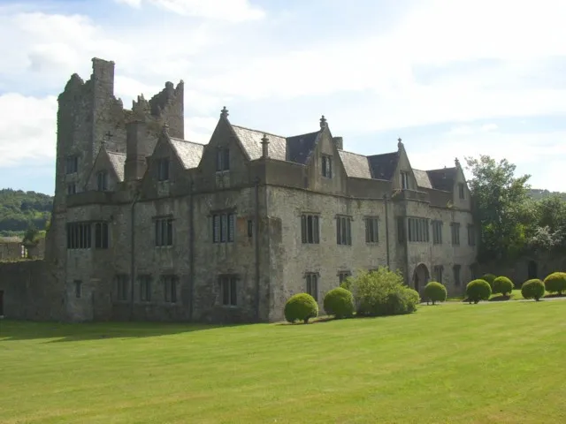
Ormonde Castle Humphrey Bolton · CC BY-SA 2.0

Climate of Tennislee Cross Roads
Best months for sightseeingBest months for sightseeing: June–August.
This month · November
A wet month
Day 11° · Night 5° · Rain 101 mm
- Hottest month
- July (day 20°)
- Coldest month
- January (night 3°)
- Wettest month
- January (111 mm)
- Driest month
- July (59 mm)
Bars: average monthly low and high temperature. Below: precipitation. Monthly averages for 1970–2000 at about 18 km resolution, adjusted for elevation. Highlighted months are mild and relatively dry. Source: WorldClim 2.1 (CC BY 4.0).
Show values as a table
| Month | Jan | Feb | Mar | Apr | May | Jun | Jul | Aug | Sep | Oct | Nov | Dec |
|---|---|---|---|---|---|---|---|---|---|---|---|---|
| Average high (°C) | 8° | 9° | 11° | 13° | 16° | 18° | 20° | 20° | 17° | 14° | 11° | 9° |
| Average low (°C) | 3° | 3° | 4° | 5° | 7° | 10° | 12° | 12° | 10° | 7° | 5° | 3° |
| Precipitation (mm) | 111 | 90 | 78 | 62 | 71 | 60 | 59 | 82 | 82 | 105 | 101 | 110 |
How to get to Tennislee Cross Roads
The nearest airport is Cork International Airport (ORK), 98 km to the southwest as the crow flies. The nearest large city is Cork, 94 km to the southwest.
Airports
- Cork International Airport (ORK) Cork 98 kmsouthwest
- Shannon Airport (SNN) Shannon 117 kmwest
- Dublin Airport (DUB) Dublin 140 kmnortheast
Nearby large cities
- Cork Population: 224K 94 kmsouthwest
- Limerick Population: 102.3K 97 kmnorthwest
- Dublin Population: 1M 132 kmnortheast
- Swansea Population: 300.4K 244 kmeast
- Belfast Population: 348K 268 kmnorth
Straight-line distances; road distances are longer. Airport data: OurAirports.
Day trips from Tennislee Cross Roads
Within 100 km: 235 historic and cultural sites, 669 natural sites, 361 lakes, rivers and coasts.
0–25 km114 places
- Sheep Island Island 24 kmS
- Coumshingaun Lough Lake 18 kmSW
- Lough Coumfea Lake 22 kmSW
- Ballin Lough Lake 17 kmS
25–60 km377 places
- Saltee Islands Island 54 kmSE
- Keeragh Islands Island 42 kmE
- Gull Island Island 26 kmS
- Cull Island Island 48 kmE
60–100 km774 places
- Curracloe Beach Beach 64 kmE
- Saint Thomas Island Island 98 kmNW
- Rocky Island Island 88 kmSW
- Ringaskiddy Island Island 89 kmSW
Straight-line distances.
Nearby attractions & nature
Everything nearby-
Pil River River, County Kilkenny2.1 km W
-
Brownswood Natural site, Munster3.4 km W
-
Tower Hill Mountain, Waterford3.6 km SW
-
Corbally Hill Mountain, County Kilkenny4.9 km NE
-
Corbally Wood Natural site, County Kilkenny5 km NE
-
Lingaun River River, County Kilkenny4.5 km W
Other cities and towns in County Kilkenny
-
 Mullinavat Village, County Kilkenny10 km E
-
Kilmacow Village, County Kilkenny8.9 km E
-
Barrabehy Village, County Kilkenny3 km NE
-
Sandpits Cross Roads Village, County Kilkenny3.6 km N
-
Grange Village, County Kilkenny4 km SE
-
The Sweep Village, County Kilkenny4.5 km NW
Sources & licences
Data last updated: