- Population
- 368
- 368
- Elevation
- 152 m
- above sea level
- Local time
- UTC+00:00
- Europe/Dublin · UTC+00:00
- Airports
- KIR Kerry Airport10 km
- ORK Cork International Airport73 km
About Kilcummin Farmhill
Kilcummin Farmhill is a village. Location: County Kerry, Munster. Population: 368. Elevation: 152 m.
Kilcummin (Irish: Cill Chuimín, meaning 'St Cummin's church') is a village in County Kerry, Ireland, about 6 kilometres (4 mi) north-east of Killarney. The population was 612 at the 2022 census. Kilcummin GAA Club was formed in 1910 and competes in Gaelic football. Seán Kelly, currently an MEP and formerly GAA president, was born in Kilcummin. Founded in 1979, Mastergeeha FC is a local association football (soccer) club.
Source: Wikipedia · CC BY-SA 4.0
Photos of Kilcummin Farmhill
-
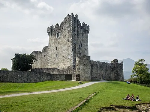
Ross Castle Dumphasizer · CC BY-SA 2.0

Climate of Kilcummin Farmhill
Best months for sightseeingBest months for sightseeing: June–August.
This month · November
A wet month
Day 11° · Night 5° · Rain 161 mm
- Hottest month
- July (day 18°)
- Coldest month
- January (night 3°)
- Wettest month
- December (177 mm)
- Driest month
- July (71 mm)
Bars: average monthly low and high temperature. Below: precipitation. Monthly averages for 1970–2000 at about 18 km resolution, adjusted for elevation. Highlighted months are mild and relatively dry. Source: WorldClim 2.1 (CC BY 4.0).
Show values as a table
| Month | Jan | Feb | Mar | Apr | May | Jun | Jul | Aug | Sep | Oct | Nov | Dec |
|---|---|---|---|---|---|---|---|---|---|---|---|---|
| Average high (°C) | 8° | 9° | 10° | 12° | 14° | 17° | 18° | 18° | 16° | 13° | 11° | 9° |
| Average low (°C) | 3° | 3° | 4° | 5° | 7° | 10° | 12° | 11° | 10° | 8° | 5° | 4° |
| Precipitation (mm) | 172 | 125 | 125 | 77 | 87 | 77 | 71 | 92 | 112 | 146 | 161 | 177 |
How to get to Kilcummin Farmhill
The nearest airport is Kerry Airport (KIR), 10 km to the northwest as the crow flies. For international flights: Cork International Airport (ORK) (73 km). The nearest large city is Cork, 72 km to the east.
Airports
- Kerry Airport (KIR) Farranfore 10 kmnorthwest
- Cork International Airport (ORK) Cork 73 kmsoutheast
- Shannon Airport (SNN) Shannon 76 kmnortheast
Nearby large cities
- Cork Population: 224K 72 kmeast
- Limerick Population: 102.3K 85 kmnortheast
- Dublin Population: 1M 257 kmnortheast
- Belfast Population: 348K 364 kmnortheast
- Swansea Population: 300.4K 384 kmeast
Straight-line distances; road distances are longer. Airport data: OurAirports.
Day trips from Kilcummin Farmhill
Within 100 km: 158 historic and cultural sites, 964 natural sites, 793 lakes, rivers and coasts.
0–25 km271 places
- Brown Island Island 9 kmSW
- Ross Island Island 8 kmSW
- Lamb Island Island 8 kmSW
- Innisfallen Island 9 kmSW
25–60 km844 places
- Banna Strand Beach 37 kmNW
- Inch beach Beach 35 kmW
- Rossbeigh Strand Beach 35 kmW
- Derrynane Beach Beach 59 kmSW
60–100 km800 places
- Valentia Island Island 66 kmW
- White Strand Beach 70 kmSW
- White Strand Beach 73 kmN
- Bush Island Island 79 kmNE
Straight-line distances.
Nearby attractions & nature
Everything nearby-
Lockagh Lake Lake, County Kerry1.9 km SE
-
Kilbrean Lake Lake, County Kerry2 km SE
-
Cnoc an Tseagail Mor Mountain, County Kerry3.6 km NE
-
Dooneen Bridge Landmark, County Kerry3.5 km NW
-
Ballahacommane Mountain, County Kerry5.8 km SE
-
Lough Dooling Lake, County Kerry5 km E
Other cities and towns in County Kerry
-
 Fossa Village, County Kerry8.3 km SW
-
Barry’s Glyn Village, County Kerry4.8 km NW
-
Inchicorrigane Village, County Kerry5.5 km NE
-
Woodford Village, County Kerry5.7 km S
-
Dromhale Village, County Kerry5.7 km SW
-
Faughbane Village, County Kerry5.9 km S
Sources & licences
Data last updated: · 2 independent sources