Villaggio Santa Rita
Located in Galatone, Province of Lecce Coordinates: 40°07′33″ N 18°00′43″ E
- Population
- 15
- 15
- Elevation
- 67 m
- above sea level
- Local time
- UTC+01:00
- Europe/Rome · UTC+01:00
- Airports
- BDS Brindisi Airport59 km
- CRV Crotone Sant'Anna Pythagoras Airport149 km
About Villaggio Santa Rita
Villaggio Santa Rita is a village. Location: Galatone, Province of Lecce. Population: 15. Elevation: 67 m. The best months to visit are May–June, September–October. The nearest airport is Brindisi Airport (59 km). Nearby sights include Torre dell'Alto Lido and Le Quattro Colonne.
Photos of Villaggio Santa Rita
-
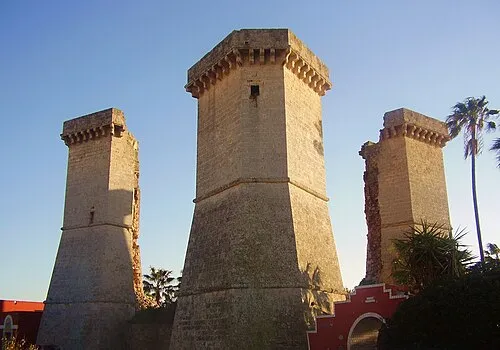
Le Quattro Colonne Lupiae · CC BY-SA 3.0 -
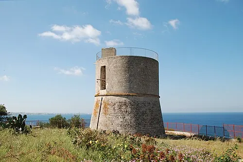
Torre dell'Alto Lido Fabrizio Garrisi · CC BY-SA 4.0


Climate of Villaggio Santa Rita
Best months for sightseeingBest months for sightseeing: May–June, September–October.
This month · November
Outside the best season
Day 17° · Night 11° · Rain 83 mm
- Hottest month
- July (day 30°)
- Coldest month
- January (night 6°)
- Wettest month
- November (83 mm)
- Driest month
- July (12 mm)
Bars: average monthly low and high temperature. Below: precipitation. Monthly averages for 1970–2000 at about 18 km resolution, adjusted for elevation. Highlighted months are mild and relatively dry. Source: WorldClim 2.1 (CC BY 4.0).
Show values as a table
| Month | Jan | Feb | Mar | Apr | May | Jun | Jul | Aug | Sep | Oct | Nov | Dec |
|---|---|---|---|---|---|---|---|---|---|---|---|---|
| Average high (°C) | 13° | 13° | 15° | 18° | 22° | 27° | 30° | 30° | 26° | 22° | 17° | 14° |
| Average low (°C) | 6° | 7° | 8° | 10° | 14° | 18° | 21° | 21° | 18° | 15° | 11° | 8° |
| Precipitation (mm) | 66 | 52 | 54 | 32 | 22 | 14 | 12 | 24 | 43 | 79 | 83 | 68 |
Other places to visit in this season: May June September October
How to get to Villaggio Santa Rita
The nearest airport is Brindisi Airport (BDS), 59 km to the north as the crow flies. The nearest large city is Durrës, 180 km to the northeast.
Airports
- Brindisi Airport (BDS) Brindisi 59 kmnorth
- Crotone Sant'Anna Pythagoras Airport (CRV) Isola di Capo Rizzuto (KR) 149 kmsouthwest
- Bari Karol Wojtyła International Airport (BRI) Bari 154 kmnorthwest
Nearby large cities
- Durrës Population: 195.9K 180 kmnortheast
- Tirana Population: 418.5K 203 kmnortheast
- Podgorica Population: 236.9K 278 kmnorth
- Prizren Population: 171.5K 326 kmnortheast
- Skopje Population: 474.9K 355 kmnortheast
Straight-line distances; road distances are longer. Airport data: OurAirports.
Day trips from Villaggio Santa Rita
Within 100 km: 12 historic and cultural sites, 11 natural sites, 50 lakes, rivers and coasts.
0–25 km18 places
- Blue Bay Beach Beach 10 kmS
- Spiaggia la Puritate Beach 8 kmS
- Punta della suina Beach 14 kmS
- Spiaggia Porto Cesareo Beach 18 kmNW
25–60 km38 places
- Spiaggia di Porto Grande Beach 42 kmE
- Castello di Otranto Historic site 41 kmE
- Spiaggia di Porto Miggiano Beach 38 kmE
- Spiaggia Alimini Beach 39 kmE
60–100 km17 places
- Lido Bruno Beach 74 kmNW
- Spiaggia Castellaneta Marina Beach 98 kmNW
- Spiaggia San Vito Beach 75 kmNW
- Capo San Francesco Natural site 70 kmNW
Straight-line distances.
Nearby attractions & nature
Everything nearby-
Torre dell'Alto Lido Landmark, Galatone1.2 km S
-
Le Quattro Colonne Landmark, Nardò1.2 km W
-
Spiaggia Padula Bianca Beach, Italy3 km S
-
Spiaggia la Puritate Beach, Gallipoli8.4 km S
-
Blue Bay Beach Beach, Gallipoli9.6 km S
-
Spiaggia Baia Verde Beach, Gallipoli9.9 km S
Sources & licences
Data last updated: · 2 independent sources