- Population
- 285
- 285
- Elevation
- 87 m
- above sea level
- Local time
- UTC+01:00
- Europe/Rome · UTC+01:00
- Airports
- QSR Salerno Costa d'Amalfi Airport92 km
- SUF Lamezia Terme Sant'Eufemia International Airport135 km
About Acquafredda
Acquafredda is a village. Location: Maratea, Province of Potenza. Population: 285. Elevation: 87 m.
Acquafredda is a coastal hamlet (frazione) in the municipality of Maratea, Province of Potenza, Basilicata, southern Italy. It is situated on the Tyrrhenian Sea at the northern end of the Maratea coastline. The settlement takes its name from a freshwater spring that flows onto the nearby Portacquafridda beach. The hamlet's beaches have held Blue Flag certification from the Foundation for Environmental Education since 2007.
Source: Wikipedia · CC BY-SA 4.0
Photos of Acquafredda
-
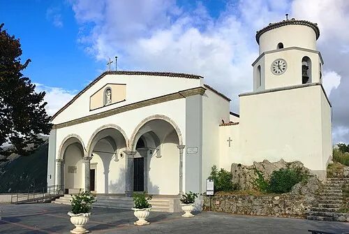
Basilica di San Biagio Luke18389 at Italian Wikipedia · CC BY 3.0

Climate of Acquafredda
Best months for sightseeingBest months for sightseeing: May–June, September–October.
This month · November
A wet month
Day 17° · Night 11° · Rain 115 mm
- Hottest month
- August (day 29°)
- Coldest month
- January (night 7°)
- Wettest month
- November (115 mm)
- Driest month
- July (21 mm)
Bars: average monthly low and high temperature. Below: precipitation. Monthly averages for 1970–2000 at about 18 km resolution, adjusted for elevation. Highlighted months are mild and relatively dry. Source: WorldClim 2.1 (CC BY 4.0).
Show values as a table
| Month | Jan | Feb | Mar | Apr | May | Jun | Jul | Aug | Sep | Oct | Nov | Dec |
|---|---|---|---|---|---|---|---|---|---|---|---|---|
| Average high (°C) | 12° | 12° | 15° | 18° | 23° | 26° | 29° | 29° | 26° | 21° | 17° | 13° |
| Average low (°C) | 7° | 7° | 9° | 11° | 15° | 19° | 21° | 22° | 19° | 15° | 11° | 8° |
| Precipitation (mm) | 91 | 90 | 79 | 82 | 54 | 34 | 21 | 36 | 62 | 98 | 115 | 113 |
Other places to visit in this season: May June September October
How to get to Acquafredda
The nearest airport is Salerno Costa d'Amalfi Airport (QSR), 92 km to the northwest as the crow flies. For international flights: Lamezia Terme Sant'Eufemia International Airport (SUF) (135 km). The nearest large city is Split, 391 km to the north.
Airports
- Salerno Costa d'Amalfi Airport (QSR) Salerno 92 kmnorthwest
- Lamezia Terme Sant'Eufemia International Airport (SUF) Lamezia Terme (CZ) 135 kmsouth
- Naples International Airport (NAP) Napoli 151 kmnorthwest
Nearby large cities
- Split Population: 149.8K 391 kmnorth
Straight-line distances; road distances are longer. Airport data: OurAirports.
Day trips from Acquafredda
Within 100 km: 13 historic and cultural sites, 55 natural sites, 22 lakes, rivers and coasts.
0–25 km7 places
- Monte del Papa Mountain 17 kmNE
- Spiaggia Dell'Arcomagno Beach 23 kmSE
- Monte Castagnareto Mountain 13 kmNE
- Monte Rotondo Mountain 18 kmN
25–60 km17 places
- Spiaggia Cirella di Diamante Beach 38 kmS
- Spiaggia del Troncone Beach 29 kmW
- Mingardo Beach 31 kmW
- Spiaggia di Scalea Beach 27 kmS
60–100 km66 places
- SoundRise Beach Beach 84 kmE
- Marina di Schiavonea Beach 85 kmSE
- Spiaggia Villaggio Thurium Beach 82 kmSE
- Spiaggia Salicetti Beach 83 kmSE
Straight-line distances.
Nearby attractions & nature
Everything nearby-
Basilica di San Biagio Attraction, Maratea6.7 km SE
-
Monte Castagnareto Mountain, Lagonegro13 km NE
-
Monte del Papa Mountain, Lagonegro17 km NE
-
Monte Rotondo Mountain, Casaletto Spartano18 km N
-
Valle Sciarapatamo Natural site, Campania20 km NW
-
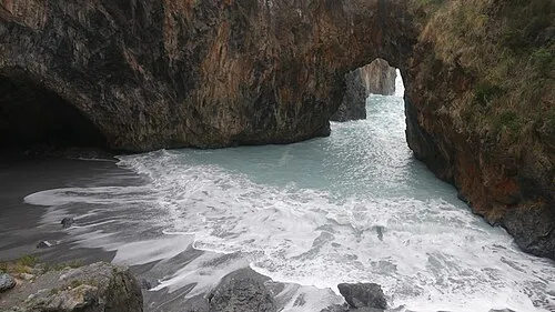 Spiaggia Dell'Arcomagno Beach, San Nicola Arcella23 km SE
Other cities and towns in Maratea
-
 Massa Village, Maratea8.3 km SE
-
Santa Caterina Village, Maratea7.2 km SE
-
Brefaro Village, Maratea9.1 km SE
-
Castrocucco Village, Maratea13 km SE
Sources & licences
Data last updated: · 2 independent sources