Toano
Located in Province of Reggio Emilia, Emilia-Romagna Coordinates: 44°22′35″ N 10°33′40″ E
- Population
- 4,367
- 4.4K
- Elevation
- 860 m
- above sea level
- Local time
- UTC+01:00
- Europe/Rome · UTC+01:00
- Places inside
- 45
- listed under Toano
- Airports
- PMF Parma Airport54 km
- BLQ Bologna Guglielmo Marconi Airport61 km
About Toano
Toano is a municipality. Location: Province of Reggio Emilia, Emilia-Romagna. Population: 4,367. Elevation: 860 m. The best months to visit are June–September. The nearest airport is Parma Airport (54 km). Nearby sights include Monte Santa Giulia and Monte Cusna.
Climate of Toano
Best months for sightseeingBest months for sightseeing: June–September.
This month · November
A wet month
Day 8° · Night 0° · Rain 109 mm
- Hottest month
- July (day 25°)
- Coldest month
- January (night -4°)
- Wettest month
- November (109 mm)
- Driest month
- July (51 mm)
Bars: average monthly low and high temperature. Below: precipitation. Monthly averages for 1970–2000 at about 18 km resolution, adjusted for elevation. Highlighted months are mild and relatively dry. Source: WorldClim 2.1 (CC BY 4.0).
Show values as a table
| Month | Jan | Feb | Mar | Apr | May | Jun | Jul | Aug | Sep | Oct | Nov | Dec |
|---|---|---|---|---|---|---|---|---|---|---|---|---|
| Average high (°C) | 4° | 5° | 9° | 12° | 17° | 22° | 25° | 25° | 20° | 14° | 8° | 5° |
| Average low (°C) | -4° | -4° | -1° | 2° | 6° | 10° | 12° | 12° | 9° | 5° | 0° | -3° |
| Precipitation (mm) | 66 | 60 | 78 | 101 | 71 | 76 | 51 | 81 | 92 | 104 | 109 | 79 |
Other places to visit in this season: June July August September
How to get to Toano
The nearest airport is Parma Airport (PMF), 54 km to the northwest as the crow flies. For international flights: Bologna Guglielmo Marconi Airport (BLQ) (61 km). The nearest large city is Nice, 274 km to the west.
Airports
- Parma Airport (PMF) Parma (PR) 54 kmnorthwest
- Bologna Guglielmo Marconi Airport (BLQ) Bologna 61 kmeast
- Pisa International Airport (PSA) Pisa (PI) 78 kmsouth
Nearby large cities
- Nice Population: 342.7K 274 kmwest
- Rijeka Population: 108K 324 kmeast
- Innsbruck Population: 132.5K 327 kmnorth
- Ljubljana Population: 272.2K 361 kmnortheast
- Zurich Population: 415.4K 367 kmnorthwest
Straight-line distances; road distances are longer. Airport data: OurAirports.
Day trips from Toano
Within 100 km: 60 historic and cultural sites, 207 natural sites, 25 lakes, rivers and coasts.
0–25 km32 places
- Monte Santa Giulia Mountain 8 kmE
- Monte Lama Mountain 15 kmSE
- Monte Cusna Mountain 17 kmSW
- Monte Albano Mountain 23 kmS
25–60 km94 places
- Correggio Beach Beach 45 kmN
- Spiaggia Forte dei Marmi Beach 56 kmSW
- Spiaggia Marina di Pietrasanta Beach 58 kmSW
- Spiaggia Lido di Camaiore Beach 60 kmSW
60–100 km166 places
- Rotteri Mountain 95 kmW
- Poggio di Iavello Mountain 62 kmSE
- Gifarco Mountain 99 kmW
- Spiaggia per Cani Beach 98 kmS
Straight-line distances.
Places in Toano
45 places- 1 Cavola 762
- 2 Toano 695
- 3 Cerredolo 403
- 4 La Ca' 205
- 5 Quara 149
- 6 Vogno 104
- 7 La Valle 82
- 8 Sabbione di Cerrè Marrabino 67
- 9 Ca' Marangone 64
- 10 L'Oca 63
- 11 La Collina 59
- 12 Roncolo 42
- 13 Vecchieda-Le Buche 41
- 14 Ca' Bagnoli 40
- 15 Ca' Baccano 38
- 16 Castelvecchio 38
- 17 Corneto 36
- 18 Ca' Casalotto 34
- 19 Frale 33
- 20 Svolta 30
- 21 Manno 28
- 22 Montebiotto 28
- 23 Ca' Cavalletti 26
- 24 Riale 26
- 25 Polcione 25
- 26 Montechiodo 24
- 27 Rondanello 24
- 28 Ca' Marastoni 23
- 29 La Crocetta 23
- 30 Stiano 23
- 31 Ca' del Re 21
- 32 Carbalano 20
- 33 Lignano 19
- 34 Poggiolo 17
- 35 Riva di Cavola 16
- 36 Cassinadro 15
- 37 Lupazzo 15
- 38 Comenzano 14
- 39 Salvarana 13
- 40 Castagnola 12
- 41 Massa 12
- 42 Ponte Dolo 12
- 43 Roncaciso 12
- 44 Bonzeto 10
- 45 Fora 8
Bar: population relative to the most populous place in this list.
Nearby attractions & nature
Everything nearby-
Monte Santa Giulia Mountain, Palagano8.2 km E
-
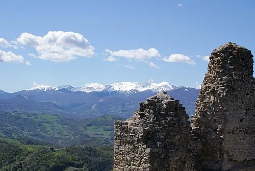 Monte Cusna Mountain, Villa Minozzo17 km SW
-
Monte San Martino Mountain, Polinago10 km E
-
Monte Cantiere Mountain, Tuscany13 km SE
-
Monte Prampa Mountain, Tuscany13 km SW
-
Monte Cisa Mountain, Tuscany14 km SW
-
Monte Lama Mountain, Lama Mocogno15 km SE
-
Monte S. Andrea Mountain, Tuscany15 km S
Sources & licences
Data last updated: