- Population
- 21
- 21
- Elevation
- 950 m
- above sea level
- Local time
- UTC+01:00
- Europe/Rome · UTC+01:00
- Airports
- PSR Abruzzo Airport76 km
- PEG Perugia San Francesco d'Assisi – Umbria International Airport82 km
About Prato
Prato is a village. Location: Amatrice, Province of Rieti. Population: 21. Elevation: 950 m. The best months to visit are June–September. The nearest airport is Abruzzo Airport (76 km). Nearby sights include Pizzo di Sevo and Cima Lepri.
Photos of Prato
-
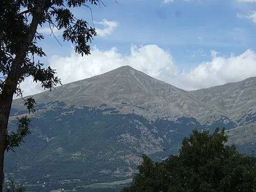
Pizzo di Sevo Mario1952 · CC BY-SA 3.0

Climate of Prato
Best months for sightseeingBest months for sightseeing: June–September.
This month · November
A cold month
Day 10° · Night 3° · Rain 81 mm
- Hottest month
- July (day 24°)
- Coldest month
- February (night -1°)
- Wettest month
- October (99 mm)
- Driest month
- January (41 mm)
Bars: average monthly low and high temperature. Below: precipitation. Monthly averages for 1970–2000 at about 18 km resolution, adjusted for elevation. Highlighted months are mild and relatively dry. Source: WorldClim 2.1 (CC BY 4.0).
Show values as a table
| Month | Jan | Feb | Mar | Apr | May | Jun | Jul | Aug | Sep | Oct | Nov | Dec |
|---|---|---|---|---|---|---|---|---|---|---|---|---|
| Average high (°C) | 5° | 5° | 8° | 12° | 17° | 20° | 24° | 24° | 20° | 15° | 10° | 6° |
| Average low (°C) | -1° | -1° | 1° | 4° | 8° | 12° | 15° | 15° | 11° | 8° | 3° | 0° |
| Precipitation (mm) | 41 | 51 | 50 | 66 | 81 | 82 | 73 | 71 | 93 | 99 | 81 | 57 |
Other places to visit in this season: June July August September
How to get to Prato
The nearest airport is Abruzzo Airport (PSR), 76 km to the east as the crow flies. The nearest large city is Split, 273 km to the east.
Airports
- Abruzzo Airport (PSR) Pescara 76 kmeast
- Perugia San Francesco d'Assisi – Umbria International Airport (PEG) Perugia (PG) 82 kmnorthwest
- Marche Airport (AOI) Falconara Marittima (AN) 109 kmnorth
Nearby large cities
- Split Population: 149.8K 273 kmeast
- Rijeka Population: 108K 313 kmnorth
- Ljubljana Population: 272.2K 392 kmnorth
Straight-line distances; road distances are longer. Airport data: OurAirports.
Day trips from Prato
Within 100 km: 143 historic and cultural sites, 273 natural sites, 31 lakes, rivers and coasts.
0–25 km32 places
- Monte Guaidone Mountain 18 kmNW
- Monte Scalandro Mountain 10 kmNE
- Monte San Franco Mountain 22 kmS
- Monte Pozzoni Mountain 12 kmW
25–60 km198 places
- Giulianova Beach Beach 56 kmE
- Spiaggia Roseto degli Abruzzi Beach 59 kmE
- La spiaggia del Surabaja Beach 58 kmE
- Riviera delle Palme Beach 59 kmNE
60–100 km217 places
- Appennino Umbro Mountain 83 kmNW
- Ripari di Giobbe Beach 94 kmE
- Valle Cerrese Natural site 60 kmSW
- Spiaggia Marina Palmense Beach 71 kmNE
Straight-line distances.
Nearby attractions & nature
Everything nearby-
Pizzo di Sevo Mountain, Amatrice5.2 km NE
-
Cima Lepri Mountain, Umbria5.6 km E
-
Monte della Laghetta Mountain, Abruzzo7.6 km SE
-
Monte Pelone Mountain, Valle Castellana7.4 km NE
-
Pizzo di Moscio Mountain, Umbria7.8 km E
-
Monte Pallone Mountain, Abruzzo7.9 km E
Sources & licences
Data last updated: · 2 independent sources