Alba Longa
Located in Castel Gandolfo, Province of Rome Coordinates: 41°44′24″ N 12°39′12″ E

- Elevation
- 412 m
- above sea level
- Local time
- UTC+01:00
- Europe/Rome · UTC+01:00
- Airports
- CIA Ciampino–G. B. Pastine International Airport8 km
- FCO Rome–Fiumicino Leonardo da Vinci International Airport34 km
About Alba Longa
Alba Longa is a village. Location: Castel Gandolfo, Province of Rome. Elevation: 412 m.
Alba Longa (occasionally written Albalonga in Italian sources) was an ancient Latin city in Central Italy in the vicinity of Lake Albano in the Alban Hills. The ancient Romans believed it to be the founder and head of the Latin League, before it was destroyed by the Roman Kingdom around the middle of the 7th century BC and its inhabitants were forced to settle in Rome.
Source: Wikipedia · CC BY-SA 4.0
At a glance
- Built
- 12th century BC
- Heritage designation
- Italian national heritage
Source: Wikidata
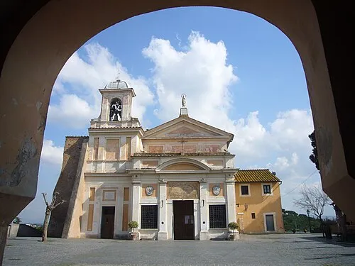
Photos of Alba Longa
-

? / Coldeel · Public domain -

Stadio Pio XII InfattiVedeteCheViDice · Public domain


Climate of Alba Longa
Best months for sightseeingBest months for sightseeing: May–July, September.
This month · November
A wet month
Day 14° · Night 6° · Rain 115 mm
- Hottest month
- August (day 29°)
- Coldest month
- January (night 2°)
- Wettest month
- November (115 mm)
- Driest month
- July (18 mm)
Bars: average monthly low and high temperature. Below: precipitation. Monthly averages for 1970–2000 at about 18 km resolution, adjusted for elevation. Highlighted months are mild and relatively dry. Source: WorldClim 2.1 (CC BY 4.0).
Show values as a table
| Month | Jan | Feb | Mar | Apr | May | Jun | Jul | Aug | Sep | Oct | Nov | Dec |
|---|---|---|---|---|---|---|---|---|---|---|---|---|
| Average high (°C) | 10° | 11° | 13° | 16° | 21° | 25° | 28° | 29° | 24° | 20° | 14° | 11° |
| Average low (°C) | 2° | 2° | 4° | 6° | 10° | 14° | 16° | 17° | 14° | 10° | 6° | 3° |
| Precipitation (mm) | 85 | 77 | 67 | 67 | 46 | 30 | 18 | 35 | 72 | 98 | 115 | 97 |
Other places to visit in this season: May June July September
How to get to Alba Longa
The nearest airport is Ciampino–G. B. Pastine International Airport (CIA), 8 km to the northwest as the crow flies. The nearest large city is Split, 367 km to the northeast.
Airports
- Ciampino–G. B. Pastine International Airport (CIA) Rome 8 kmnorthwest
- Rome–Fiumicino Leonardo da Vinci International Airport (FCO) Rome 34 kmwest
- Abruzzo Airport (PSR) Pescara 148 kmnortheast
Nearby large cities
- Split Population: 149.8K 367 kmnortheast
Straight-line distances; road distances are longer. Airport data: OurAirports.
Day trips from Alba Longa
Within 100 km: 131 historic and cultural sites, 166 natural sites, 43 lakes, rivers and coasts.
0–25 km88 places
- Spiaggia di Rio Torto Beach 21 kmSW
- Spiaggia Torvaianica Beach 21 kmSW
- Spiaggia Marina di Ardea Beach 23 kmSW
- Zion Beach Beach 22 kmSW
25–60 km59 places
- Lido di Latino Beach 41 kmSE
- Campo di Mare Beach 57 kmNW
- Spiaggia Lavinio Beach 27 kmS
- Balneare la Baia Beach Beach 55 kmNW
60–100 km193 places
- Valle Cerrese Natural site 67 kmN
- Sombrero Beach 71 kmSE
- La Bussola Beach 67 kmSE
- Spiaggia delle Bambole Beach 88 kmSE
Straight-line distances.
Nearby attractions & nature
Everything nearby-
Stadio Pio XII Landmark, Albano Laziale1 km S
-
Monte Due Torri Mountain, Genzano di Roma5.9 km SE
-
Monte Faete Mountain, Rocca di Papa6.7 km E
-
Colle Iano Mountain, Rocca di Papa7.3 km NE
-
 Santuario della Madonna del Divino Amore Attraction, Municipio Roma IX10 km NW
-
Maschio dell'Artemisio Mountain, Velletri8.8 km E
Sources & licences
Data last updated: · 2 independent sources