Valle Marciana
Located in Grottaferrata, Province of Rome Coordinates: 41°47′30″ N 12°38′38″ E
- Population
- 35
- 35
- Elevation
- 190 m
- above sea level
- Local time
- UTC+01:00
- Europe/Rome · UTC+01:00
- Airports
- CIA Ciampino–G. B. Pastine International Airport4 km
- FCO Rome–Fiumicino Leonardo da Vinci International Airport33 km
About Valle Marciana
Valle Marciana is a village. Location: Grottaferrata, Province of Rome. Population: 35. Elevation: 190 m. The best months to visit are May–June, September–October. The nearest airport is Ciampino–G. B. Pastine International Airport (4 km). Nearby sights include Stadio Pio XII and Santuario della Madonna del Divino Amore.
Photos of Valle Marciana
-

Stadio Pio XII InfattiVedeteCheViDice · Public domain

Climate of Valle Marciana
Best months for sightseeingBest months for sightseeing: May–June, September–October.
This month · November
A wet month
Day 16° · Night 7° · Rain 115 mm
- Hottest month
- August (day 30°)
- Coldest month
- January (night 3°)
- Wettest month
- November (115 mm)
- Driest month
- July (18 mm)
Bars: average monthly low and high temperature. Below: precipitation. Monthly averages for 1970–2000 at about 18 km resolution, adjusted for elevation. Highlighted months are mild and relatively dry. Source: WorldClim 2.1 (CC BY 4.0).
Show values as a table
| Month | Jan | Feb | Mar | Apr | May | Jun | Jul | Aug | Sep | Oct | Nov | Dec |
|---|---|---|---|---|---|---|---|---|---|---|---|---|
| Average high (°C) | 12° | 13° | 15° | 17° | 22° | 26° | 30° | 30° | 26° | 21° | 16° | 12° |
| Average low (°C) | 3° | 3° | 5° | 8° | 12° | 15° | 18° | 18° | 15° | 12° | 7° | 4° |
| Precipitation (mm) | 85 | 77 | 67 | 67 | 46 | 30 | 18 | 35 | 72 | 98 | 115 | 97 |
Other places to visit in this season: May June September October
How to get to Valle Marciana
The nearest airport is Ciampino–G. B. Pastine International Airport (CIA), 4 km to the west as the crow flies. The nearest large city is Split, 365 km to the northeast.
Airports
- Ciampino–G. B. Pastine International Airport (CIA) Rome 4 kmwest
- Rome–Fiumicino Leonardo da Vinci International Airport (FCO) Rome 33 kmwest
- Perugia San Francesco d'Assisi – Umbria International Airport (PEG) Perugia (PG) 145 kmnorth
Nearby large cities
- Split Population: 149.8K 365 kmnortheast
Straight-line distances; road distances are longer. Airport data: OurAirports.
Day trips from Valle Marciana
Within 100 km: 133 historic and cultural sites, 175 natural sites, 39 lakes, rivers and coasts.
0–25 km86 places
- Spiaggia di Rio Torto Beach 25 kmSW
- Spiaggia Torvaianica Beach 24 kmSW
- Zion Beach Beach 24 kmSW
- Settimo Cielo Beach Beach 24 kmSW
25–60 km70 places
- Lido di Latino Beach 46 kmSE
- Campo di Mare Beach 54 kmW
- Spiaggia Marina di Ardea Beach 28 kmS
- Spiaggia Lavinio Beach 33 kmS
60–100 km191 places
- Valle Cerrese Natural site 62 kmN
- Sombrero Beach 76 kmSE
- La Bussola Beach 73 kmSE
- Spiaggia delle Bambole Beach 93 kmSE
Straight-line distances.
Nearby attractions & nature
Everything nearby-
Stadio Pio XII Landmark, Albano Laziale6.7 km S
-
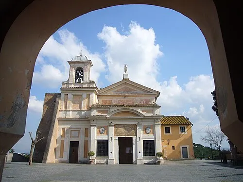 Santuario della Madonna del Divino Amore Attraction, Municipio Roma IX8.4 km W
-
Colle Iano Mountain, Rocca di Papa7.9 km E
-
Monte Faete Mountain, Rocca di Papa8.8 km SE
-
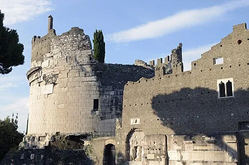 Tomb of Caecilia Metella Historic site, Municipio Roma VII12 km NW
-
Monte Fiore Mountain, Rocca Priora11 km E
Sources & licences
Data last updated: · 2 independent sources