Basilica di Sant'Andrea
Located in Vercelli, Province of Vercelli Coordinates: 45°19′43″ N 8°25′08″ E
- Local time
- UTC+01:00
- Europe/Rome · UTC+01:00
- Elevation
- 139 m
- above sea level
- Airports
- MXP Milan Malpensa International Airport41 km
- TRN Turin Airport62 km
About Basilica di Sant'Andrea
Basilica di Sant'Andrea is a tourist attraction. Location: Vercelli, Province of Vercelli.
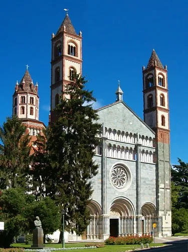
The Basilica di Sant'Andrea is the church of a monastery in Vercelli, Piedmont, northern Italy, founded in 1219 by Cardinal Guala Bicchieri and completed in 1227. It represents an early example of Gothic architecture in Italy, inspired by Cistercian models and featuring Romanesque elements as well.
Source: Wikipedia · CC BY-SA 4.0
At a glance
- Built
- 1219
- Architectural style
- Gothic architecture, Italian Gothic architecture
- Heritage designation
- Italian national heritage
- Official website
- santandreavercelli.com
Source: Wikidata
Photos of Basilica di Sant'Andrea
-

Mongolo1984 · CC BY-SA 4.0 -

Mongolo1984 · CC BY-SA 4.0 -

Mongolo1984 · CC BY-SA 4.0


Climate of Basilica di Sant'Andrea
Best months for sightseeingBest months for sightseeing: May–July, September.
This month · November
A cold month
Day 11° · Night 2° · Rain 68 mm
- Hottest month
- July (day 27°)
- Coldest month
- January (night -2°)
- Wettest month
- May (100 mm)
- Driest month
- December (44 mm)
Bars: average monthly low and high temperature. Below: precipitation. Monthly averages for 1970–2000 at about 18 km resolution, adjusted for elevation. Highlighted months are mild and relatively dry. Source: WorldClim 2.1 (CC BY 4.0).
Show values as a table
| Month | Jan | Feb | Mar | Apr | May | Jun | Jul | Aug | Sep | Oct | Nov | Dec |
|---|---|---|---|---|---|---|---|---|---|---|---|---|
| Average high (°C) | 6° | 8° | 14° | 17° | 21° | 25° | 27° | 27° | 23° | 17° | 11° | 6° |
| Average low (°C) | -2° | -1° | 3° | 7° | 12° | 15° | 17° | 17° | 13° | 8° | 2° | -1° |
| Precipitation (mm) | 52 | 49 | 67 | 86 | 100 | 67 | 45 | 70 | 67 | 91 | 68 | 44 |
Other places to visit in this season: May June July September
How to get to Basilica di Sant'Andrea
The nearest airport is Milan Malpensa International Airport (MXP), 41 km to the northeast as the crow flies. The nearest large city is Lausanne, 191 km to the northwest.
Airports
- Milan Malpensa International Airport (MXP) Ferno (VA) 41 kmnortheast
- Turin Airport (TRN) Caselle Torinese (TO) 62 kmwest
- Milano Linate Airport (LIN) Segrate (MI) 68 kmeast
Nearby large cities
- Lausanne Population: 139.1K 191 kmnorthwest
- Bern Population: 121.6K 195 kmnorth
- Geneva Population: 201.7K 202 kmnorthwest
- Nice Population: 342.7K 203 kmsouthwest
- Grenoble Population: 158.6K 213 kmwest
Straight-line distances; road distances are longer. Airport data: OurAirports.
Day trips from Basilica di Sant'Andrea
Within 100 km: 83 historic and cultural sites, 854 natural sites, 50 lakes, rivers and coasts.
25–60 km99 places
- Punta delle Vecchia Mountain 57 kmNW
- Spiaggia del Sasso Cavallazzo Beach 54 kmN
- Spiaggia dei Caravalle Beach 53 kmN
- Isola San Giulio Island 52 kmN
60–100 km888 places
- Isole di Brissago Island 93 kmN
- Sant' Apollinare Island 93 kmN
- San Pancrazio Island 93 kmN
- Laghetto di Muzzano Lake 84 kmNE
Straight-line distances.
Nearest towns and villages
-
 Canton Biliemme Village, Vercelli2.8 km SE
-
Campora Village, Vercelli2 km NW
-
Cominetti Village, Vercelli2.4 km W
-
Cascina Mostioli Village, Vercelli2.6 km E
Sources & licences
Data last updated: · 2 independent sources