- Population
- 17
- 17
- Elevation
- 342 m
- above sea level
- Local time
- UTC+01:00
- Europe/Rome · UTC+01:00
- Airports
- FLR Florence Airport, Peretola21 km
- PSA Pisa International Airport47 km
About La Villa
La Villa is a village. Location: Vinci, Province of Florence. Population: 17. Elevation: 342 m. The best months to visit are May–July, September. The nearest airport is Florence Airport, Peretola (21 km).
Photos of La Villa
-
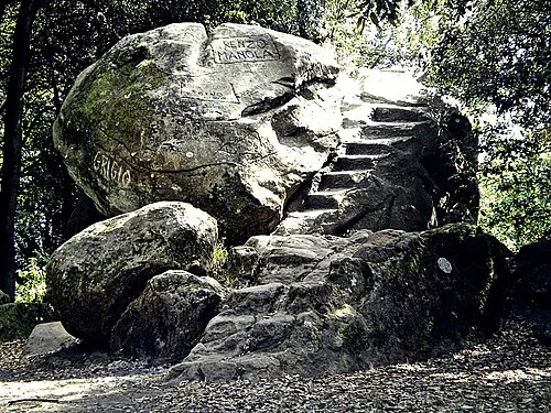
Monte Pietramarina Massimilianogalardi · CC BY-SA 3.0

Climate of La Villa
Best months for sightseeingBest months for sightseeing: May–July, September.
This month · November
A wet month
Day 13° · Night 4° · Rain 118 mm
- Hottest month
- July (day 29°)
- Coldest month
- January (night 0°)
- Wettest month
- November (118 mm)
- Driest month
- July (35 mm)
Bars: average monthly low and high temperature. Below: precipitation. Monthly averages for 1970–2000 at about 18 km resolution, adjusted for elevation. Highlighted months are mild and relatively dry. Source: WorldClim 2.1 (CC BY 4.0).
Show values as a table
| Month | Jan | Feb | Mar | Apr | May | Jun | Jul | Aug | Sep | Oct | Nov | Dec |
|---|---|---|---|---|---|---|---|---|---|---|---|---|
| Average high (°C) | 9° | 10° | 13° | 16° | 21° | 25° | 29° | 29° | 24° | 19° | 13° | 9° |
| Average low (°C) | 0° | 1° | 3° | 6° | 10° | 13° | 16° | 16° | 13° | 9° | 4° | 1° |
| Precipitation (mm) | 70 | 63 | 71 | 84 | 65 | 56 | 35 | 58 | 88 | 113 | 118 | 83 |
Other places to visit in this season: May June July September
How to get to La Villa
The nearest airport is Florence Airport, Peretola (FLR), 21 km to the east as the crow flies. The nearest large city is Nice, 297 km to the west.
Airports
- Florence Airport, Peretola (FLR) Firenze (FI) 21 kmeast
- Pisa International Airport (PSA) Pisa (PI) 47 kmwest
- Bologna Guglielmo Marconi Airport (BLQ) Bologna 85 kmnorth
Nearby large cities
- Nice Population: 342.7K 297 kmwest
- Rijeka Population: 108K 325 kmnortheast
- Ljubljana Population: 272.2K 375 kmnortheast
- Innsbruck Population: 132.5K 385 kmnorth
Straight-line distances; road distances are longer. Airport data: OurAirports.
Day trips from La Villa
Within 100 km: 68 historic and cultural sites, 213 natural sites, 31 lakes, rivers and coasts.
0–25 km50 places
- Poggio di Iavello Mountain 21 kmNE
- Monte Morello Mountain 24 kmE
- I Fornelli Mountain 6 kmSE
- Poggio Ferrato Mountain 16 kmNE
25–60 km97 places
- Spiaggia libera per cani Beach 58 kmSW
- La Lecciona Beach 56 kmW
- Spiaggia Lido di Camaiore Beach 59 kmW
- Spiaggia Viareggio Beach 57 kmW
60–100 km165 places
- Ultima Spiaggia Beach 100 kmS
- Mirollino Beach 98 kmS
- Altamarea Beach 97 kmS
- Ultima Spiaggia Beach 94 kmS
Straight-line distances.
Sources & licences
Data last updated: