- Population
- 20
- 20
- Elevation
- 630 m
- above sea level
- Local time
- UTC+01:00
- Europe/Rome · UTC+01:00
- Airports
- PSA Pisa International Airport54 km
- PMF Parma Airport74 km
About Foresto
Foresto is a village. Location: Minucciano, Province of Lucca. Population: 20. Elevation: 630 m. The best months to visit are June–September. The nearest airport is Pisa International Airport (54 km). Nearby sights include Pizzo Maggiore and Monte Contrario.
Photos of Foresto
-
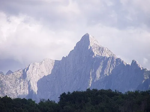
Monte Pizzo d'Uccello Lorenzo Antiga · CC BY-SA 3.0

Climate of Foresto
Best months for sightseeingBest months for sightseeing: June–September.
This month · November
A wet month
Day 11° · Night 4° · Rain 227 mm
- Hottest month
- July (day 25°)
- Coldest month
- January (night 1°)
- Wettest month
- November (227 mm)
- Driest month
- July (52 mm)
Bars: average monthly low and high temperature. Below: precipitation. Monthly averages for 1970–2000 at about 18 km resolution, adjusted for elevation. Highlighted months are mild and relatively dry. Source: WorldClim 2.1 (CC BY 4.0).
Show values as a table
| Month | Jan | Feb | Mar | Apr | May | Jun | Jul | Aug | Sep | Oct | Nov | Dec |
|---|---|---|---|---|---|---|---|---|---|---|---|---|
| Average high (°C) | 7° | 8° | 10° | 13° | 18° | 22° | 25° | 25° | 21° | 16° | 11° | 8° |
| Average low (°C) | 1° | 1° | 3° | 5° | 9° | 12° | 15° | 15° | 12° | 8° | 4° | 2° |
| Precipitation (mm) | 164 | 129 | 141 | 156 | 110 | 96 | 52 | 88 | 142 | 205 | 227 | 180 |
Other places to visit in this season: June July August September
How to get to Foresto
The nearest airport is Pisa International Airport (PSA), 54 km to the south as the crow flies. The nearest large city is Nice, 245 km to the west.
Airports
- Pisa International Airport (PSA) Pisa (PI) 54 kmsouth
- Parma Airport (PMF) Parma (PR) 74 kmnorth
- Florence Airport, Peretola (FLR) Firenze (FI) 86 kmsoutheast
Nearby large cities
- Nice Population: 342.7K 245 kmwest
- Rijeka Population: 108K 357 kmnortheast
- Innsbruck Population: 132.5K 356 kmnorth
- Toulon Population: 168.7K 367 kmwest
- Grenoble Population: 158.6K 377 kmwest
Straight-line distances; road distances are longer. Airport data: OurAirports.
Day trips from Foresto
Within 100 km: 59 historic and cultural sites, 260 natural sites, 38 lakes, rivers and coasts.
0–25 km41 places
- Spiaggia Forte dei Marmi Beach 23 kmS
- Spiaggia Marinella di Sarzana Beach 22 kmSW
- La Goletta Beach Beach 23 kmSW
- Spiaggia Marina di Massa Beach 21 kmSW
25–60 km88 places
- La Lecciona Beach 35 kmS
- Spiaggia della Marinella di San Terenzo Beach 29 kmW
- La Spiaggia di Levanto Beach 51 kmW
- Spiaggia Marina di Pietrasanta Beach 26 kmS
60–100 km228 places
- Rotteri Mountain 82 kmNW
- Poggio di Iavello Mountain 70 kmE
- Gifarco Mountain 84 kmNW
- Bagni Pagana Beach 84 kmW
Straight-line distances.
Nearby attractions & nature
Everything nearby-
Pizzo Maggiore Mountain, Emilia-Romagna4.2 km SW
-
Monte Contrario Mountain, Massa5.5 km SW
-
Monte Cavallo Mountain, Emilia-Romagna5 km SW
-
Monte Pizzo d'Uccello Mountain, Fivizzano5.6 km W
-
Monte Posola Mountain, Sillano Giuncugnano11 km N
-
Monte Tondo Mountain, Fivizzano11 km N
Other cities and towns in Minucciano
-
Albiano Village, Minucciano4.3 km NW
-
Casone Carpinelli Village, Minucciano4.9 km N
-
 Pieve San Lorenzo Village, Minucciano5.7 km NW
-
Castagnola Village, Minucciano1.9 km N
-
Minucciano Village, Minucciano3.5 km NW
-
Metra Village, Minucciano6.1 km NW
Sources & licences
Data last updated: · 2 independent sources