- Population
- 7
- 7
- Elevation
- 1,015 m
- above sea level
- Local time
- UTC+01:00
- Europe/Rome · UTC+01:00
- Airports
- TSF Treviso Airport54 km
- BZO Bolzano Airport59 km
About Col Perer
Col Perer is a village. Location: Arsiè, Province of Belluno. Population: 7. Elevation: 1,015 m. The best months to visit are June–August. The nearest airport is Treviso Airport (54 km). Nearby sights include Col Perre and Monega Di Campo.
Photos of Col Perer
-
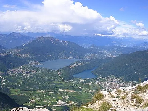
Val Sugana Ago76 · Public domain

Climate of Col Perer
Best months for sightseeingBest months for sightseeing: June–August.
This month · November
A cold month
Day 7° · Night 0° · Rain 63 mm
- Hottest month
- July (day 22°)
- Coldest month
- January (night -4°)
- Wettest month
- June (100 mm)
- Driest month
- February (34 mm)
Bars: average monthly low and high temperature. Below: precipitation. Monthly averages for 1970–2000 at about 18 km resolution, adjusted for elevation. Highlighted months are mild and relatively dry. Source: WorldClim 2.1 (CC BY 4.0).
Show values as a table
| Month | Jan | Feb | Mar | Apr | May | Jun | Jul | Aug | Sep | Oct | Nov | Dec |
|---|---|---|---|---|---|---|---|---|---|---|---|---|
| Average high (°C) | 3° | 4° | 8° | 11° | 16° | 20° | 22° | 22° | 18° | 13° | 7° | 3° |
| Average low (°C) | -4° | -3° | -1° | 3° | 8° | 11° | 13° | 13° | 10° | 5° | 0° | -3° |
| Precipitation (mm) | 35 | 34 | 44 | 60 | 87 | 100 | 96 | 96 | 84 | 86 | 63 | 39 |
How to get to Col Perer
The nearest airport is Treviso Airport (TSF), 54 km to the southeast as the crow flies. The nearest large city is Innsbruck, 142 km to the north.
Airports
- Treviso Airport (TSF) Treviso (TV) 54 kmsoutheast
- Bolzano Airport (BZO) Bolzano (BZ) 59 kmnorthwest
- Venice Marco Polo Airport (VCE) Venezia (VE) 74 kmsoutheast
Nearby large cities
- Innsbruck Population: 132.5K 142 kmnorth
- Klagenfurt Population: 100.3K 209 kmeast
- Ljubljana Population: 272.2K 215 kmeast
- Salzburg Population: 157.2K 223 kmnortheast
- Rijeka Population: 108K 224 kmeast
Straight-line distances; road distances are longer. Airport data: OurAirports.
Day trips from Col Perer
Within 100 km: 63 historic and cultural sites, 1,551 natural sites, 27 lakes, rivers and coasts.
0–25 km73 places
- Mislkopf Mountain 23 kmNW
- Cima del Frate Mountain 17 kmNW
- Col Moscher Mountain 24 kmE
- Monte Tesoro Mountain 20 kmSE
25–60 km612 places
- Piz Gralba Mountain 57 kmN
- Piz Miara Mountain 57 kmN
- Croda Nera Mountain 47 kmN
- Santa Corona Attraction 53 kmS
60–100 km956 places
- Burano Island 79 kmSE
- Sacca Fisola Island 79 kmSE
- San Clemente Island 81 kmSE
- Spadalone Mountain 80 kmW
Straight-line distances.
Nearby attractions & nature
Everything nearby-
Col Perre Mountain, Lamon2.6 km N
-
Monega Di Campo Mountain, Arsiè3.8 km W
-
Val Sugana Natural site, Trentino-Alto Adige5.3 km W
-
Monte Roncon Mountain, Seren del Grappa7.4 km SE
-
Monte Picosta Mountain, Castello Tesino7 km NW
-
Monte Valnappe Mountain, Castello Tesino7.1 km W
Other cities and towns in Arsiè
-
Solivo Village, Arsiè4.1 km SW
-
Villaggio Nuovo Village, Arsiè5.3 km S
-
 San Vito Village, Arsiè5.7 km S
-
Tol Village, Arsiè3.8 km SE
-
 Rocca Village, Arsiè6.4 km S
-
Area Artigianale Village, Arsiè4.1 km SE
Sources & licences
Data last updated: