- Population
- 307,672
- 307.7K
- Elevation
- 14 m
- above sea level
- Local time
- UTC+09:00
- Asia/Tokyo · UTC+09:00
- Airports
- AXT Akita Airport14 km
- ONJ Odate Noshiro Airport57 km
About Akita
Akita is a city. Location: Akita Shi, Akita. Population: 307,672. Elevation: 14 m. The best months to visit are May–June, September. The nearest airport is Akita Airport (14 km). Nearby sights include Omono River and Akita Port Tower.
Photos of Akita
-
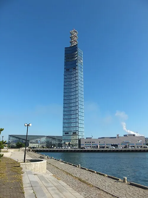
Akita Port Tower 掬茶 · CC BY-SA 4.0

Climate of Akita
Best months for sightseeingBest months for sightseeing: May–June, September.
This month · November
A wet month
Day 12° · Night 4° · Rain 153 mm
- Hottest month
- August (day 28°)
- Coldest month
- January (night -3°)
- Wettest month
- July (172 mm)
- Driest month
- March (97 mm)
Bars: average monthly low and high temperature. Below: precipitation. Monthly averages for 1970–2000 at about 18 km resolution, adjusted for elevation. Highlighted months are mild and relatively dry. Source: WorldClim 2.1 (CC BY 4.0).
Show values as a table
| Month | Jan | Feb | Mar | Apr | May | Jun | Jul | Aug | Sep | Oct | Nov | Dec |
|---|---|---|---|---|---|---|---|---|---|---|---|---|
| Average high (°C) | 3° | 3° | 7° | 14° | 19° | 23° | 26° | 28° | 24° | 18° | 12° | 6° |
| Average low (°C) | -3° | -3° | -1° | 5° | 10° | 15° | 19° | 21° | 16° | 9° | 4° | 0° |
| Precipitation (mm) | 136 | 108 | 97 | 103 | 97 | 119 | 172 | 153 | 170 | 144 | 153 | 165 |
How to get to Akita
The nearest airport is Akita Airport (AXT), 14 km to the southeast as the crow flies. The nearest large city is Morioka, 89 km to the east.
Airports
- Akita Airport (AXT) Akita 14 kmsoutheast
- Odate Noshiro Airport (ONJ) Kitaakita 57 kmnorth
- Iwate Hanamaki Airport (HNA) Hanamaki 93 kmeast
Nearby large cities
- Morioka Population: 290.7K 89 kmeast
- Sakata Population: 100.3K 92 kmsouth
- Hirosaki Population: 168.7K 102 kmnorth
- Ōshū Population: 112.9K 111 kmsoutheast
- Tsuruoka Population: 125.4K 113 kmsouth
Straight-line distances; road distances are longer. Airport data: OurAirports.
Day trips from Akita
Within 100 km: 1 historic or cultural site, 9 natural sites, 11 lakes, rivers and coasts.
0–25 km3 places
- Akita Port Tower Landmark 6 kmNW
- Hachirō Lagoon Lake 24 kmNW
- Omono River River 5 kmSW
25–60 km6 places
- Yoneshiro River River 57 kmN
- Lake Tazawa Lake 47 kmE
- Mount Akita-Komagatake Mountain 59 kmE
- Oga Quasi National Park Natural site 38 kmNW
60–100 km12 places
- Tobi Shima Island 75 kmSW
- Waga River River 100 kmSE
- Mogami River River 92 kmS
- Mount Chōkai Mountain 68 kmS
Straight-line distances.
Akita and similar cities
Side by side with cities of similar size in the same country: population, elevation and climate.
| Measure | Akita | Kasugai | Yokkaichi | Akashi |
|---|---|---|---|---|
| Population | 307.7K | 308.7K | 305.4K | 303.6K |
| Elevation | 14 m | 30 m | 8 m | 37 m |
| Summer day (hottest month) | 28° | 32° | 31° | 32° |
| Winter night (coldest month) | -3° | 0° | 1° | 1° |
| Annual rainfall | 1,617 mm | 1,974 mm | 1,784 mm | 1,321 mm |
| Best months | May–Jun, Sep | Apr–Jun, Oct | May–Jun, Oct | May, Oct |
| Distance | — | 569 km | 612 km | 722 km |
Climate values are 1970–2000 monthly averages; straight-line distance.
Nearby attractions & nature
Everything nearby-
Omono River River, Japan5.1 km SW
-
Akita Port Tower Landmark, Akita Shi6.2 km NW
-
 Hachirō Lagoon Lake, Akita24 km NW
Sources & licences
Data last updated: