- Population
- 23,435
- 23.4K
- Elevation
- 47 m
- above sea level
- Local time
- UTC+09:00
- Asia/Tokyo · UTC+09:00
- Airports
- AXT Akita Airport45 km
- SYO Shonai Airport53 km
About Nikaho
Nikaho is a city. Location: Nikaho-shi, Akita. Population: 23,435. Elevation: 47 m. The best months to visit are May–June, September. The nearest airport is Akita Airport (45 km). Nearby sights include Mount Chōkai and Koyoshi River.
Climate of Nikaho
Best months for sightseeingBest months for sightseeing: May–June, September.
This month · November
A wet month
Day 12° · Night 4° · Rain 187 mm
- Hottest month
- August (day 29°)
- Coldest month
- January (night -2°)
- Wettest month
- December (191 mm)
- Driest month
- May (99 mm)
Bars: average monthly low and high temperature. Below: precipitation. Monthly averages for 1970–2000 at about 18 km resolution, adjusted for elevation. Highlighted months are mild and relatively dry. Source: WorldClim 2.1 (CC BY 4.0).
Show values as a table
| Month | Jan | Feb | Mar | Apr | May | Jun | Jul | Aug | Sep | Oct | Nov | Dec |
|---|---|---|---|---|---|---|---|---|---|---|---|---|
| Average high (°C) | 3° | 4° | 7° | 14° | 19° | 22° | 26° | 29° | 24° | 18° | 12° | 6° |
| Average low (°C) | -2° | -2° | -1° | 5° | 10° | 15° | 19° | 21° | 16° | 10° | 4° | 0° |
| Precipitation (mm) | 156 | 120 | 107 | 108 | 99 | 126 | 177 | 167 | 173 | 159 | 187 | 191 |
How to get to Nikaho
The nearest airport is Akita Airport (AXT), 45 km to the northeast as the crow flies. The nearest large city is Sakata, 40 km to the south.
Airports
- Akita Airport (AXT) Akita 45 kmnortheast
- Shonai Airport (SYO) Shonai 53 kmsouth
- Yamagata Airport (GAJ) Higashine 102 kmsouth
Nearby large cities
- Sakata Population: 100.3K 40 kmsouth
- Akita Population: 307.7K 52 kmnorth
- Tsuruoka Population: 125.4K 62 kmsouth
- Ōshū Population: 112.9K 107 kmeast
- Ichinoseki Population: 114.5K 111 kmeast
Straight-line distances; road distances are longer. Airport data: OurAirports.
Day trips from Nikaho
Within 100 km: 1 historic or cultural site, 9 natural sites, 8 lakes, rivers and coasts.
0–25 km2 places
- Koyoshi River River 15 kmNE
- Mount Chōkai Mountain 21 kmSE
25–60 km5 places
- Tobi Shima Island 34 kmW
- Akita Port Tower Landmark 55 kmN
- Aka River River 49 kmS
- Omono River River 48 kmN
60–100 km11 places
- Oga Quasi National Park Natural site 74 kmN
- Oga Peninsula Natural site 72 kmN
- Dewa Sanzan Mountain 70 kmS
- Haguro Yama Mountain 63 kmS
Straight-line distances.
Nearby attractions & nature
Everything nearby-
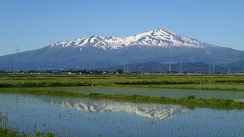 Mount Chōkai Mountain, Yuza Machi21 km SE
-
Koyoshi River River, Akita15 km NE
Sources & licences
Data last updated: