Mount Chōkai
Local name: 鳥海山
Located in Yuza Machi, Akumi-gun Coordinates: 39°06′08″ N 140°02′45″ E
- Elevation
- 2,236 m
- above sea level
- Local time
- UTC+09:00
- Asia/Tokyo · UTC+09:00
- Airports
- SYO Shonai Airport39 km
- AXT Akita Airport59 km
About Mount Chōkai
Mount Chōkai is a mountain. Location: Yuza Machi, Akumi-gun. Elevation: 2,236 m.
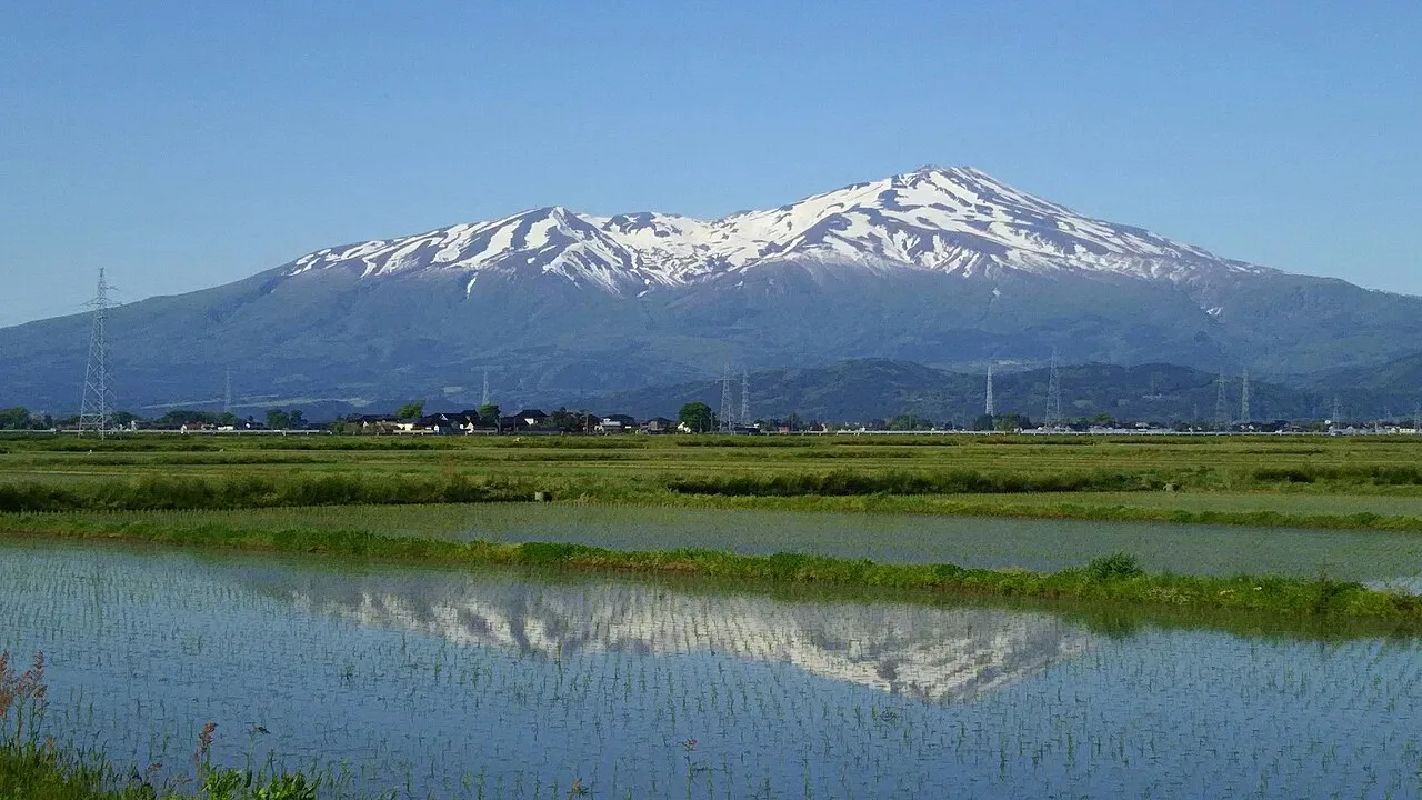
Mount Chōkai (鳥海山, Chōkai-san or Chōkai-zan) is an active volcano located on the border of Akita and Yamagata in the Tōhoku region of Japan, and is 2,236 m (7,336 ft) tall. Because of its (roughly) symmetrical shape and massive size, it is also variously known as Dewa Fuji (出羽富士), Akita Fuji (秋田富士) or Shōnai Fuji (庄内富士) depending on the location of the viewer.
Source: Wikipedia · CC BY-SA 4.0
Photos of Mount Chōkai
-

Raita Futo from Tokyo, Japan · CC BY 2.0 -

皓月旗 · CC BY-SA 4.0 -

Raita Futo from Tokyo, Japan · CC BY 2.0 -

Koda6029 · CC BY-SA 4.0 -

Koda6029 · CC BY-SA 4.0


Climate of Mount Chōkai
This month · November
A wet month
Day -2° · Night -9° · Rain 162 mm
- Hottest month
- August (day 16°)
- Coldest month
- February (night -17°)
- Wettest month
- August (205 mm)
- Driest month
- March (104 mm)
Bars: average monthly low and high temperature. Below: precipitation. Monthly averages for 1970–2000 at about 18 km resolution, adjusted for elevation. Highlighted months are mild and relatively dry. Source: WorldClim 2.1 (CC BY 4.0).
Show values as a table
| Month | Jan | Feb | Mar | Apr | May | Jun | Jul | Aug | Sep | Oct | Nov | Dec |
|---|---|---|---|---|---|---|---|---|---|---|---|---|
| Average high (°C) | -11° | -11° | -8° | -1° | 5° | 10° | 14° | 16° | 11° | 5° | -2° | -8° |
| Average low (°C) | -17° | -17° | -15° | -9° | -4° | 2° | 6° | 8° | 3° | -4° | -9° | -14° |
| Precipitation (mm) | 136 | 108 | 104 | 117 | 111 | 144 | 195 | 205 | 187 | 147 | 162 | 154 |
How to get to Mount Chōkai
The nearest airport is Shonai Airport (SYO), 39 km to the southwest as the crow flies. The nearest large city is Sakata, 26 km to the southwest.
Airports
- Shonai Airport (SYO) Shonai 39 kmsouthwest
- Akita Airport (AXT) Akita 59 kmnorth
- Yamagata Airport (GAJ) Higashine 82 kmsouth
Nearby large cities
- Sakata Population: 100.3K 26 kmsouthwest
- Tsuruoka Population: 125.4K 47 kmsouthwest
- Akita Population: 307.7K 68 kmnorth
- Ichinoseki Population: 114.5K 96 kmeast
- Ōshū Population: 112.9K 97 kmeast
Straight-line distances; road distances are longer. Airport data: OurAirports.
Day trips from Mount Chōkai
Within 100 km: 2 historic and cultural sites, 11 natural sites, 12 lakes, rivers and coasts.
25–60 km6 places
- Tobi Shima Island 44 kmW
- Koyoshi River River 32 kmN
- Dewa Sanzan Mountain 52 kmS
- Aka River River 36 kmSW
60–100 km19 places
- Awashima Island Island 100 kmSW
- Oga Quasi National Park Natural site 94 kmN
- Mount Funagata Mountain 88 kmSE
- Oga Peninsula Natural site 92 kmN
Straight-line distances.
Nearest towns and villages


Sources & licences
Data last updated: · 2 independent sources