- Population
- 68,302
- 68.3K
- Elevation
- 27 m
- above sea level
- Local time
- UTC+09:00
- Asia/Tokyo · UTC+09:00
- Airports
- KMQ Komatsu Airport / JASDF Komatsu Air Base53 km
- NKM Nagoya Airport / JASDF Komaki Air Base102 km
About Sabae
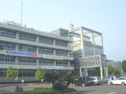
Sabae is a city. Location: Sabae Shi, Fukui. Population: 68,302. Elevation: 27 m.
Sabae (鯖江市, Sabae-shi) is a city located in Fukui Prefecture, Japan. As of 1 March 2026, the city had an estimated population of 67,932 in 26,546 households and the population density of 820 persons per km2. The total area of the city is 84.59 square kilometres (32.66 sq mi).
Read more on Wikipedia Text: Wikipedia contributors · CC BY-SA 4.0 · shortened
Places bordering Sabae
- Fukui-shi
- Echizen
- Ikeda Chō
Population of Sabae over time
| 2010 | 67,450 | |
|---|---|---|
| 2015 | 68,284 | |
| 2021 | 68,666 |
Censuses and official estimates; source: Wikidata.
Climate of Sabae
Best months for sightseeingBest months for sightseeing: May–June, September–October.
Bars: average monthly low and high temperature. Below: precipitation. Monthly averages for 1970–2000 at about 18 km resolution, adjusted for elevation. Highlighted months are mild and relatively dry. Source: WorldClim 2.1 (CC BY 4.0).
Show values as a table
| Month | Jan | Feb | Mar | Apr | May | Jun | Jul | Aug | Sep | Oct | Nov | Dec |
|---|---|---|---|---|---|---|---|---|---|---|---|---|
| Average high (°C) | 6° | 6° | 10° | 17° | 22° | 25° | 29° | 31° | 26° | 21° | 15° | 10° |
| Average low (°C) | 0° | 0° | 2° | 8° | 13° | 18° | 22° | 23° | 19° | 12° | 7° | 3° |
| Precipitation (mm) | 243 | 170 | 153 | 154 | 156 | 222 | 234 | 150 | 232 | 156 | 171 | 234 |
Other places to visit in this season: May June September October
Airports nearest to Sabae
- Komatsu Airport / JASDF Komatsu Air Base (KMQ) Kanazawa 53 km
- Nagoya Airport / JASDF Komaki Air Base (NKM) Nagoya 102 km
- Toyama Kitokito Airport (TOY) Toyama 119 km
Straight-line distance; airports with scheduled flights only. Source: OurAirports (public domain).
Sources & licences
Data last updated: · 2 independent sources