Yamatomachi-mitsuai
Located in Kitakata-shi, Fukushima Coordinates: 37°37′45″ N 139°46′09″ E
- Elevation
- 198 m
- above sea level
- Local time
- UTC+09:00
- Asia/Tokyo · UTC+09:00
- Airports
- KIJ Niigata Airport68 km
- FKS Fukushima Airport74 km
About Yamatomachi-mitsuai
Yamatomachi-mitsuai is a village. Location: Kitakata-shi, Fukushima. Elevation: 198 m.
Yamato (山都町, Yamato-machi) was a town located in Yama District, Fukushima Prefecture, Japan. The town was established as a village in 1875, and promoted to a town in 1954. As of 2003, the town had an estimated population of 4,092 and a density of 26.20 persons per square kilometer. The total area was 156.21 km2. On January 4, 2006, Yamato, along with the town of Shiokawa, and the villages of Atsushiokanō and Takasato (all from Yama District), was merged into the expanded city of Kitakata.
Source: Wikipedia · CC BY-SA 4.0
At a glance
- Built
- 1950
Source: Wikidata
Climate of Yamatomachi-mitsuai
Best months for sightseeingBest months for sightseeing: May–June, September.
This month · November
A wet month
Day 12° · Night 3° · Rain 108 mm
Better nearby cities in November
- Kofu · 243 km southwest17°
- Isehara · 251 km south18°
- Odawara · 270 km south19°
- Hottest month
- August (day 30°)
- Coldest month
- January (night -4°)
- Wettest month
- July (164 mm)
- Driest month
- April (85 mm)
Bars: average monthly low and high temperature. Below: precipitation. Monthly averages for 1970–2000 at about 18 km resolution, adjusted for elevation. Highlighted months are mild and relatively dry. Source: WorldClim 2.1 (CC BY 4.0).
Show values as a table
| Month | Jan | Feb | Mar | Apr | May | Jun | Jul | Aug | Sep | Oct | Nov | Dec |
|---|---|---|---|---|---|---|---|---|---|---|---|---|
| Average high (°C) | 3° | 3° | 7° | 15° | 21° | 24° | 28° | 30° | 24° | 18° | 12° | 6° |
| Average low (°C) | -4° | -4° | -1° | 5° | 10° | 15° | 20° | 21° | 16° | 9° | 3° | -1° |
| Precipitation (mm) | 125 | 96 | 89 | 85 | 86 | 127 | 164 | 131 | 150 | 115 | 108 | 123 |
How to get to Yamatomachi-mitsuai
The nearest airport is Niigata Airport (KIJ), 68 km to the northwest as the crow flies. The nearest large city is Aizu-Wakamatsu, 22 km to the southeast.
Airports
- Niigata Airport (KIJ) Niigata 68 kmnorthwest
- Fukushima Airport (FKS) Sukagawa 74 kmsoutheast
- Yamagata Airport (GAJ) Higashine 102 kmnortheast
Nearby large cities
- Aizu-Wakamatsu Population: 118.2K 22 kmsoutheast
- Kōriyama Population: 327.7K 60 kmsoutheast
- Fukushima Population: 294.2K 63 kmeast
- Nagaoka Population: 266.9K 84 kmwest
- Yamagata Population: 248.8K 85 kmnortheast
Straight-line distances; road distances are longer. Airport data: OurAirports.
Day trips from Yamatomachi-mitsuai
Within 100 km: 1 historic or cultural site, 21 natural sites, 6 lakes, rivers and coasts.
0–25 km5 places
- Echigo Sanmyaku Mountain 23 kmN
- Tadami River River 1 kmW
- Tsuruga Castle Historic site 21 kmSE
- Iimori Yama Mountain 25 kmNE
25–60 km9 places
- Lake Hibara Lake 26 kmE
- Mount Azuma-kofuji Mountain 45 kmE
- Mount Adatara Mountain 46 kmE
- Mount Nasu Mountain 59 kmS
60–100 km14 places
- Asahi Dake Mountain 73 kmN
- Mount Nikkō-Shirane Mountain 99 kmS
- Nantai San Mountain 99 kmS
- Mount Zaō Mountain 82 kmNE
Straight-line distances.
Nearby attractions & nature
Everything nearby-
Tadami River River, Fukushima1.4 km W
-
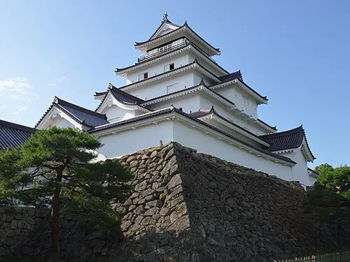 Tsuruga Castle Historic site, Aizu-wakamatsu Shi21 km SE
-
Iimori Yama Mountain, Kitakata-shi25 km NE
-
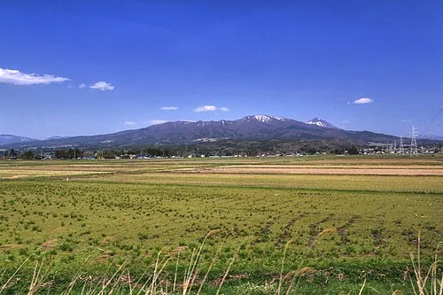 Nekomaga Dake Mountain, Bandai Machi23 km E
-
 Echigo Sanmyaku Mountain, Japan23 km N
Sources & licences
Data last updated: · 2 independent sources