- Population
- 27,439
- 27.4K
- Elevation
- 26 m
- above sea level
- Local time
- UTC+09:00
- Asia/Tokyo · UTC+09:00
- Airports
- NKM Nagoya Airport / JASDF Komaki Air Base38 km
- NGO Chubu Centrair International Airport62 km
About Tarui
Tarui is a town. Location: Tarui Chō, Fuwa-gun. Population: 27,439. Elevation: 26 m.
Tarui (垂井町, Tarui-chō) is a town located in Fuwa District, Gifu Prefecture, Japan. As of 1 December 2018, the town had an estimated population of 27,439 and a population density of 480 persons per km2, in 10,525 households. The total area of the town was 57.09 square kilometres (22.04 sq mi).
Source: Wikipedia · CC BY-SA 4.0
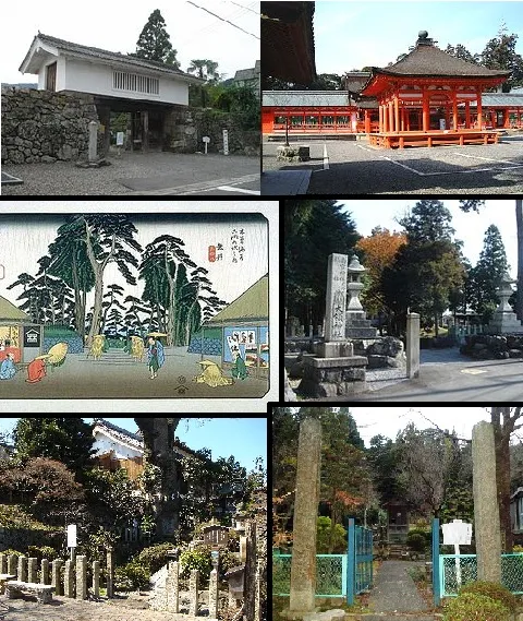
Photos of Tarui
-

gundam2345 · CC BY 3.0 -

gundam2345 · CC BY 3.0 -

大野 一将 · CC BY-SA 3.0 -

Opqr · CC BY-SA 4.0 -

Opqr · CC BY-SA 4.0


Travel notes for Tarui
From Wikivoyage
Tarui (垂井町 Tarui-chō) is a town in Gifu Prefecture near the prefectural border with Shiga Prefecture.
Understand+
Tourist information site:
The local tourist association has a Japanese-only guide site, and a panphlet in English and Japanese.
Get in+
Tarui is served by 1 Tarui Station, located along the Tokaido Main Line. All trains from the west depart from Maibara and this is the closest Shinkansen Station to Tarui. To the east, if you time it right, there are direct trains from Toyohashi that travel through Nagoya and Gifu, but quite often a transfer at Ogaki is necessary.
For drivers, Route 21 is the main highway that runs through Tarui from Sekigahara to the west and Minokamo to the east.
Source: Wikivoyage · CC BY-SA 4.0 · abridged
Places bordering Tarui
- Ōgaki
- Ibigawa Chō
- Ikeda Chō
- Sekigahara Chō
- Yōrō Chō
Population of Tarui over time
| 2010 | 28,505 | |
|---|---|---|
| 2015 | 27,556 | |
| 2020 | 26,558 |
Censuses and official estimates; source: Wikidata.
Climate of Tarui
Best months for sightseeingBest months for sightseeing: May–June, October.
This month · November
A wet month
Day 16° · Night 7° · Rain 103 mm
Better nearby cities in November
- Kofu · 187 km east17°
- Fujinomiya · 190 km east18°
- Fuji · 196 km east20°
- Hottest month
- August (day 31°)
- Coldest month
- January (night 0°)
- Wettest month
- July (268 mm)
- Driest month
- December (83 mm)
Bars: average monthly low and high temperature. Below: precipitation. Monthly averages for 1970–2000 at about 18 km resolution, adjusted for elevation. Highlighted months are mild and relatively dry. Source: WorldClim 2.1 (CC BY 4.0).
Show values as a table
| Month | Jan | Feb | Mar | Apr | May | Jun | Jul | Aug | Sep | Oct | Nov | Dec |
|---|---|---|---|---|---|---|---|---|---|---|---|---|
| Average high (°C) | 8° | 8° | 12° | 18° | 23° | 26° | 30° | 31° | 27° | 22° | 16° | 11° |
| Average low (°C) | 0° | 0° | 3° | 8° | 13° | 18° | 22° | 23° | 19° | 13° | 7° | 2° |
| Precipitation (mm) | 95 | 101 | 136 | 181 | 180 | 266 | 268 | 168 | 243 | 138 | 103 | 83 |
How to get to Tarui
The nearest airport is Nagoya Airport / JASDF Komaki Air Base (NKM), 38 km to the east as the crow flies. For international flights: Chubu Centrair International Airport (NGO) (62 km). The nearest large city is Ōgaki, 8 km to the east.
Airports
- Nagoya Airport / JASDF Komaki Air Base (NKM) Nagoya 38 kmeast
- Chubu Centrair International Airport (NGO) Tokoname 62 kmsoutheast
- Komatsu Airport / JASDF Komatsu Air Base (KMQ) Kanazawa 114 kmnorth
Nearby large cities
- Ōgaki Population: 161.5K 8 kmeast
- Gifu Population: 402.6K 22 kmeast
- Nagahama Population: 113.6K 24 kmwest
- Ichinomiya Population: 380.1K 25 kmeast
- Inazawa Population: 134.8K 26 kmsoutheast
Straight-line distances; road distances are longer. Airport data: OurAirports.
Day trips from Tarui
Within 100 km: 29 historic and cultural sites, 26 natural sites, 34 lakes, rivers and coasts.
0–25 km3 places
- Neo River River 11 kmNE
- Mount Ryōzen Mountain 17 kmSW
- Mount Ibuki Mountain 13 kmNW
25–60 km23 places
- Hida River River 48 kmE
- Nikkō River River 42 kmSE
- Hori River River 44 kmSE
- Mount Komaki Mountain 35 kmE
60–100 km63 places
- Tōshi-jima Island 99 kmS
- Himakajima Island 85 kmSE
- Kami-jima Island 100 kmSE
- Shino-jima Island 88 kmSE
Straight-line distances.
Nearby attractions & nature
Everything nearby-
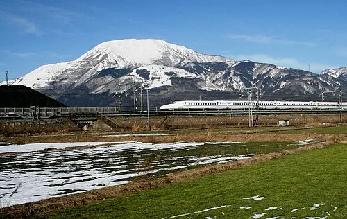 Mount Ibuki Mountain, Maibara-shi13 km NW
-
Mount Ryōzen Mountain, Taga Chō17 km SW
-
Neo River River, Gifu11 km NE
Sources & licences
Data last updated: · 2 independent sources