Kakamigahara
Local name: 各務原市
Located in Kakamigahara Shi, Gifu Coordinates: 35°25′00″ N 136°52′00″ E
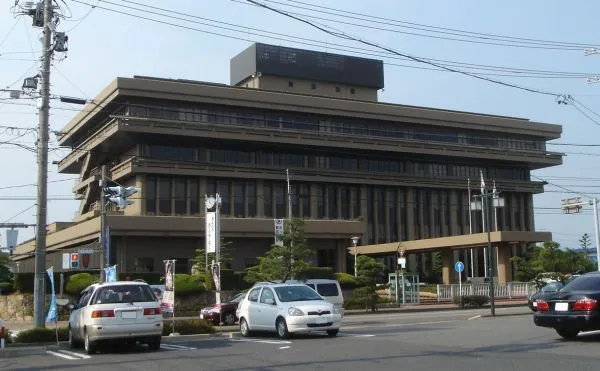
- Population
- 144,521
- 144.5K
- Elevation
- 40 m
- above sea level
- Local time
- UTC+09:00
- Asia/Tokyo · UTC+09:00
- Airports
- NKM Nagoya Airport / JASDF Komaki Air Base19 km
- NGO Chubu Centrair International Airport62 km
About Kakamigahara
Kakamigahara is a city. Location: Kakamigahara Shi, Gifu. Population: 144,521. Elevation: 40 m.
Kakamigahara (各務原市, Kakamigahara-shi) is a city located in southern Gifu Prefecture in Japan. As of 1 January 2019, the city had an estimated population of 148,225, and a population density of 1700 persons per km2, in 59,736 households. The total area of the city was 87.81 km2 (33.90 sq mi). Situated in the northern part of the Nōbi Plain, what is now Kakamigahara originally thrived as a post station on the Nakasendō highway connecting Edo with Kyoto, being called "Unuma-juku" at the time.
Source: Wikipedia · CC BY-SA 4.0
Photos of Kakamigahara
-

国土交通省 · CC BY 4.0 -

Villeneuve1982 · CC BY-SA 4.0 -

名鉄愛好家 · CC0 -

kanesue · CC BY 3.0 -

恭パパ · CC BY-SA 4.0


Places bordering Kakamigahara
- Kasamatsuchō
- Sakahogi-cho
- Seki-shi
- Gifu
- Ginan Chō
- Ichinomiya
- Kōnan
- Fusō Chō
- Inuyama
Population of Kakamigahara over time
| 2010 | 145,604 | |
|---|---|---|
| 2015 | 144,690 | |
| 2020 | 143,641 |
Censuses and official estimates; source: Wikidata.
Climate of Kakamigahara
Best months for sightseeingBest months for sightseeing: May–June, October.
This month · November
Outside the best season
Day 16° · Night 7° · Rain 99 mm
Better nearby cities in November
- Kofu · 156 km east17°
- Fujinomiya · 160 km east18°
- Fuji · 167 km east20°
- Hottest month
- August (day 31°)
- Coldest month
- January (night -1°)
- Wettest month
- July (298 mm)
- Driest month
- December (64 mm)
Bars: average monthly low and high temperature. Below: precipitation. Monthly averages for 1970–2000 at about 18 km resolution, adjusted for elevation. Highlighted months are mild and relatively dry. Source: WorldClim 2.1 (CC BY 4.0).
Show values as a table
| Month | Jan | Feb | Mar | Apr | May | Jun | Jul | Aug | Sep | Oct | Nov | Dec |
|---|---|---|---|---|---|---|---|---|---|---|---|---|
| Average high (°C) | 8° | 9° | 13° | 19° | 23° | 26° | 30° | 31° | 27° | 22° | 16° | 11° |
| Average low (°C) | -1° | 0° | 3° | 9° | 13° | 18° | 22° | 23° | 19° | 13° | 7° | 2° |
| Precipitation (mm) | 73 | 89 | 141 | 202 | 199 | 287 | 298 | 215 | 272 | 148 | 99 | 64 |
How to get to Kakamigahara
The nearest airport is Nagoya Airport / JASDF Komaki Air Base (NKM), 19 km to the south as the crow flies. For international flights: Chubu Centrair International Airport (NGO) (62 km). The nearest large city is Gifu, 10 km to the west.
Airports
- Nagoya Airport / JASDF Komaki Air Base (NKM) Nagoya 19 kmsouth
- Chubu Centrair International Airport (NGO) Tokoname 62 kmsouth
- Komatsu Airport / JASDF Komatsu Air Base (KMQ) Kanazawa 116 kmnorth
Nearby large cities
- Gifu Population: 402.6K 10 kmwest
- Ichinomiya Population: 380.1K 14 kmsouthwest
- Komaki Population: 148.9K 15 kmsouth
- Kani Population: 102.1K 17 kmeast
- Inazawa Population: 134.8K 20 kmsouth
Straight-line distances; road distances are longer. Airport data: OurAirports.
Day trips from Kakamigahara
Within 100 km: 8 historic and cultural sites, 24 natural sites, 29 lakes, rivers and coasts.
0–25 km5 places
- Neo River River 21 kmW
- Hida River River 17 kmE
- Tsubo-gawa River 6 kmN
- Inuyama castle Historic site 7 kmSE
25–60 km20 places
- Okazaki castle Historic site 58 kmSE
- Toyota Stadium Landmark 46 kmSE
- Mount Ryōzen Mountain 47 kmW
- Mount Ibuki Mountain 42 kmW
60–100 km36 places
- Tōshi-jima Island 99 kmS
- Himakajima Island 80 kmS
- Kami-jima Island 97 kmS
- Chausu-yama Mountain 97 kmNE
Straight-line distances.
Kakamigahara and similar cities
Side by side with cities of similar size in the same country: population, elevation and climate.
| Measure | Kakamigahara | Tsuchiura | Ashikaga | Fujieda |
|---|---|---|---|---|
| Population | 144.5K | 144.4K | 144.7K | 145K |
| Elevation | 40 m | 5 m | 45 m | 22 m |
| Summer day (hottest month) | 31° | 29° | 30° | 30° |
| Winter night (coldest month) | -1° | -2° | -2° | 2° |
| Annual rainfall | 2,087 mm | 1,348 mm | 1,243 mm | 2,174 mm |
| Best months | May–Jun, Oct | May–Jul, Sep–Oct | May, Oct | May–Jun, Sep–Oct |
| Distance | — | 312 km | 254 km | 141 km |
Climate values are 1970–2000 monthly averages; straight-line distance.
Nearby attractions & nature
Everything nearby-
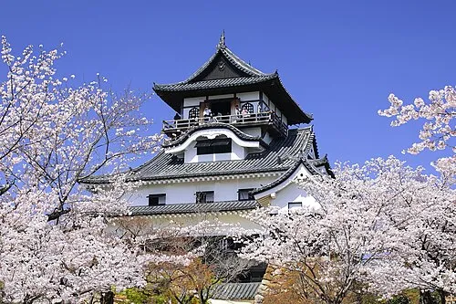 Inuyama castle Historic site, Inuyama-shi7.3 km SE
-
Tsubo-gawa River, Gifu5.9 km N
-
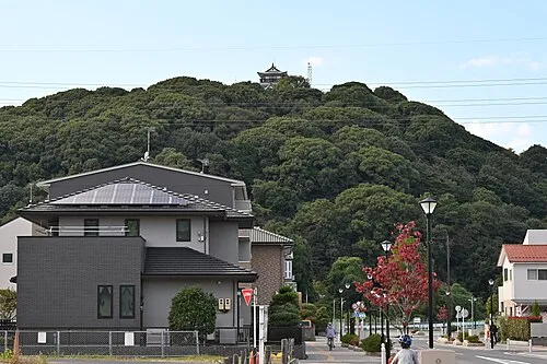 Mount Komaki Mountain, Komaki14 km S
-
 Hida River River, Gifu17 km E
-
Neo River River, Gifu21 km W
Sources & licences
Data last updated: · 2 independent sources