- Population
- 15,816
- 15.8K
- Elevation
- 213 m
- above sea level
- Local time
- UTC+09:00
- Asia/Tokyo · UTC+09:00
- Places inside
- 2
- listed under Kutchan Chō
- Airports
- OKD Sapporo Okadama Airport54 km
- CTS New Chitose Airport76 km
About Kutchan Chō
Kutchan Chō is a municipality. Location: Abuta-gun, Hokkaido. Population: 15,816. Elevation: 213 m.
Kutchan (倶知安町, Kutchan-chō) is a town located in Shiribeshi Subprefecture, Hokkaido, Japan. Kutchan lies slightly north of the volcano Mount Yōtei, and is approximately 50 kilometers west of Sapporo. The subprefecture government offices are located in this town, making it the capital of the subprefecture. As of April 30, 2017, the town has an estimated population of 15,573 and a population density of 60 persons per km². The total area is 261.24 km2 (100.87 sq mi).
Source: Wikipedia · CC BY-SA 4.0
Travel notes for Kutchan Chō
From Wikivoyage
Kutchan (倶知安) is a rural town in Shiribeshi, Hokkaido. (The "u" in the name is pronounced as 'oo' (Ū) as in "boot".)
Understand+
Tourist information sites:
The local tourist association has a bilingual guide site.
The town government's site has a Japanese-only section on tourism with integrated machine translation.
Get in+
By train:
Kutchan is on the JR Hakodate Main Line between Hakodate and Sapporo, but it is only served by local trains. From Sapporo it takes two to three hours, requiring a change of trains at Otaru, at a cost of ¥1790. It takes 3 to 4 hours from Hakodate with a change at Oshamanbe.
By bus:
From Niseko's Hirafu ski fields, Kutchan is an easy 15-minute bus ride. During the day, Donan and Hirafu bus companies operate regular services to Kutchan, one-way fare is about ¥380, depending on where you start and end. The bus will drop off at several points within the boundaries of the town, the terminus being at the JR rail station. Details are in the trail map of the Niseko United. In the winter months, there is also a free Kutchan Night Go Bus service, which runs approximately once an hour from 17:00 until 23:00. To board the free bus, you need to get a free "Kutchan Bus Passport" which is available at all information centres and most hotels.
Source: Wikivoyage · CC BY-SA 4.0 · abridged
Places bordering Kutchan Chō
- Kyōgoku
- Niseko Chō
- Niki
- Akaigawa
- Kyōwa Chō
- Rankoshimachi
Population of Kutchan Chō over time
| 2010 | 15,568 | |
|---|---|---|
| 2015 | 15,018 | |
| 2020 | 15,123 |
Censuses and official estimates; source: Wikidata.
Climate of Kutchan Chō
Best months for sightseeingBest months for sightseeing: June–September.
This month · November
A wet month
Day 7° · Night -1° · Rain 160 mm
- Hottest month
- August (day 25°)
- Coldest month
- January (night -10°)
- Wettest month
- December (166 mm)
- Driest month
- May (74 mm)
Bars: average monthly low and high temperature. Below: precipitation. Monthly averages for 1970–2000 at about 18 km resolution, adjusted for elevation. Highlighted months are mild and relatively dry. Source: WorldClim 2.1 (CC BY 4.0).
Show values as a table
| Month | Jan | Feb | Mar | Apr | May | Jun | Jul | Aug | Sep | Oct | Nov | Dec |
|---|---|---|---|---|---|---|---|---|---|---|---|---|
| Average high (°C) | -2° | -1° | 2° | 8° | 15° | 20° | 24° | 25° | 21° | 15° | 7° | 0° |
| Average low (°C) | -10° | -10° | -6° | 0° | 6° | 11° | 15° | 17° | 11° | 5° | -1° | -6° |
| Precipitation (mm) | 160 | 118 | 86 | 75 | 74 | 76 | 105 | 151 | 148 | 134 | 160 | 166 |
Other places to visit in this season: June July August September
How to get to Kutchan Chō
The nearest airport is Sapporo Okadama Airport (OKD), 54 km to the northeast as the crow flies. For international flights: New Chitose Airport (CTS) (76 km). The nearest large city is Otaru, 36 km to the northeast.
Airports
- Sapporo Okadama Airport (OKD) Sapporo 54 kmnortheast
- New Chitose Airport (CTS) Sapporo 76 kmeast
- Hakodate Airport (HKD) Hakodate 127 kmsouth
Nearby large cities
- Otaru Population: 115.3K 36 kmnortheast
- Sapporo Population: 2M 50 kmeast
- Ebetsu Population: 134K 66 kmeast
- Tomakomai Population: 174.8K 74 kmsoutheast
- Hakodate Population: 275.7K 126 kmsouth
Straight-line distances; road distances are longer. Airport data: OurAirports.
Day trips from Kutchan Chō
Within 100 km: 2 historic and cultural sites, 13 natural sites, 11 lakes, rivers and coasts.
0–25 km3 places
- Mount Shiribetsu Mountain 19 kmSE
- Mount Usu Mountain 14 kmSE
- Yōtei-zan Mountain 10 kmS
25–60 km15 places
- Zenibako River River 40 kmNE
- Raiden-yama Mountain 26 kmW
- Mount Monbetsu Mountain 53 kmE
- Mount Eniwa Mountain 44 kmE
60–100 km8 places
- Makomanai-gawa River 94 kmSW
- Tokoro River River 100 kmS
- Komaga-dake Mountain 95 kmS
- Shiribeshi-Toshibetsu River River 94 kmSW
Straight-line distances.
Places in Kutchan Chō
2 placesKutchan
Population: 15.8K
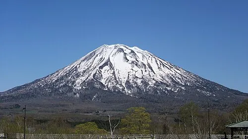
Nearby attractions & nature
Everything nearby-
Mount Usu Mountain, Japan14 km SE
-
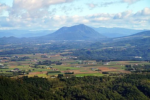 Mount Shiribetsu Mountain, Rusutsu Mura19 km SE
Sources & licences
Data last updated: · 2 independent sources