- Population
- 4,857
- 4.9K
- Elevation
- 154 m
- above sea level
- Local time
- UTC+09:00
- Asia/Tokyo · UTC+09:00
- Places inside
- 1
- listed under Niseko Chō
- Airports
- OKD Sapporo Okadama Airport69 km
- CTS New Chitose Airport83 km
About Niseko Chō
Niseko Chō is a municipality. Location: Abuta-gun, Hokkaido. Population: 4,857. Elevation: 154 m.
Niseko (Japanese: ニセコ町, Niseko-chō, [ɲ̟iseko tɕoː]) is a town located in Shiribeshi Subprefecture, Hokkaido, Japan. Niseko as a resort area refers to the Niseko tourism zone (ニセコ観光圏), which consists of the three towns of Kutchan, Niseko, and Rankoshi at the foot of Niseko Annupuri. The name Niseko is derived from the Nisekoanbetsu River (ニセコアンベツ川), meaning "river toward the cliff" in the Ainu language. The Niseko town's main income sources are agriculture and tourism.
Source: Wikipedia · CC BY-SA 4.0
Travel notes for Niseko Chō
From Wikivoyage
Niseko (ニセコ) is a town and ski resort on the northern island of Hokkaido, Japan.
Understand+
Niseko is an increasingly popular destination for powder hungry skiers and boarders, and nearly alone among Japan's ski resorts is drawing increasing numbers of overseas visitors year-on-year as well. Niseko is highly favored by Australians, and by Asian tourists. The resort boasts four ski areas: Hanazono, Hirafu, Niseko Village (formerly Higashiyama) and Annupuri. Most activity is centered on the village of Hirafu, approximately 20 minutes from the main town and administrative centre in the area, Kutchan.
Tourist information site:
The local tourist association has a bilingual guide site.
Get in+
By plane:
The nearest airport to Niseko is Sapporo's New Chitose Airport, which receives flights from all over Japan and from some international destinations.
There are direct international flights from most neighboring countries. If you come from further far away often Nagoya (Chubu) or Seoul are most convenient transfers.
By bus:
During winter months, numerous limousine bus services are provided to various ski resorts in Niseko at a cost of ¥1900-2300 each way. In addition, two public bus lines run buses from New Chitose Airport (CTS IATA) to Hirafu. Both operate on a regular timetable during the ski season, with the Chuo Bus having 5 trips each way daily while Donan Buses have 4 each way.
Times are subject to change from season to season, but each can be contacted by phone (Chuo-Bus +81 11 231 0500, and Donan-Bus +81 123 465701). In the 2017/18 season, the cost of a one-way ticket is ¥2600 and a return is ¥4500 (50% less for children). The trip takes 3½ - 4 hours, depending on the road conditions. This is an excellent way to see the countryside, the snow covered farm lands and the quaint houses.
In the 2011/12 season both bus lines offer a discounted return ticket including a strongly discounted one-day ski pass.
By train:
1 Niseko station (ニセコ駅, Niseko-eki). (updated Sep 2025) is the main railway station in Niseko. It sees a sparse local service from Oshamambe and Otaru.
If you're staying near Hirafu, the best option is to take trains to 2 Kutchan station (倶知安駅, Kutchen-eki). (updated Feb 2024)(2h), then ride a local bus to Hirafu (20 minutes).
From Sapporo:
In the evenings, the rapid Niseko Liner runs directly from Sapporo station to Kutchan. At other times take one of the frequent trains to Otaru, then change for a local service to Kutchan. The full journey takes about 3 hours.
On selected days in September, the limited express Niseko runs once daily directly from Sapporo to Niseko (2h 30min). Reservations are mandatory to board the train.
Source: Wikivoyage · CC BY-SA 4.0 · abridged
Places bordering Niseko Chō
- Kutchan Chō
- Makkari
- Rankoshimachi
Twin towns and sister cities of Niseko Chō
- Takashima· Japan
Source: Wikidata. Only places with a page on this site are shown.
Population of Niseko Chō over time
| 2010 | 4,823 | |
|---|---|---|
| 2015 | 4,958 | |
| 2020 | 4,991 |
Censuses and official estimates; source: Wikidata.
Climate of Niseko Chō
Best months for sightseeingBest months for sightseeing: June–September.
This month · November
A wet month
Day 8° · Night 0° · Rain 148 mm
- Hottest month
- August (day 25°)
- Coldest month
- January (night -9°)
- Wettest month
- August (160 mm)
- Driest month
- April (79 mm)
Bars: average monthly low and high temperature. Below: precipitation. Monthly averages for 1970–2000 at about 18 km resolution, adjusted for elevation. Highlighted months are mild and relatively dry. Source: WorldClim 2.1 (CC BY 4.0).
Show values as a table
| Month | Jan | Feb | Mar | Apr | May | Jun | Jul | Aug | Sep | Oct | Nov | Dec |
|---|---|---|---|---|---|---|---|---|---|---|---|---|
| Average high (°C) | -2° | -1° | 3° | 9° | 16° | 20° | 24° | 25° | 21° | 15° | 8° | 1° |
| Average low (°C) | -9° | -9° | -6° | 1° | 6° | 11° | 16° | 17° | 12° | 5° | 0° | -6° |
| Precipitation (mm) | 138 | 105 | 84 | 79 | 79 | 81 | 116 | 160 | 155 | 130 | 148 | 146 |
Other places to visit in this season: June July August September
How to get to Niseko Chō
The nearest airport is Sapporo Okadama Airport (OKD), 69 km to the northeast as the crow flies. For international flights: New Chitose Airport (CTS) (83 km). The nearest large city is Otaru, 53 km to the northeast.
Airports
- Sapporo Okadama Airport (OKD) Sapporo 69 kmnortheast
- New Chitose Airport (CTS) Sapporo 83 kmeast
- Hakodate Airport (HKD) Hakodate 113 kmsouth
Nearby large cities
- Otaru Population: 115.3K 53 kmnortheast
- Sapporo Population: 2M 64 kmnortheast
- Tomakomai Population: 174.8K 78 kmeast
- Ebetsu Population: 134K 80 kmnortheast
- Hakodate Population: 275.7K 112 kmsouth
Straight-line distances; road distances are longer. Airport data: OurAirports.
Day trips from Niseko Chō
Within 100 km: 2 historic and cultural sites, 14 natural sites, 11 lakes, rivers and coasts.
0–25 km4 places
- Mount Shiribetsu Mountain 19 kmE
- Raiden-yama Mountain 22 kmNW
- Mount Usu Mountain 15 kmE
- Yōtei-zan Mountain 12 kmNE
25–60 km10 places
- Zenibako River River 56 kmNE
- Mount Monbetsu Mountain 59 kmE
- Mount Eniwa Mountain 50 kmE
- Shakotan-hantō Natural site 54 kmN
60–100 km13 places
- Kamui Misaki Natural site 67 kmNW
- Makomanai-gawa River 79 kmSW
- Sapporo TV Tower Landmark 64 kmNE
- Tokoro River River 86 kmS
Straight-line distances.
Places in Niseko Chō
1 placeBar: population relative to the most populous place in this list.
Nearby attractions & nature
Everything nearby-
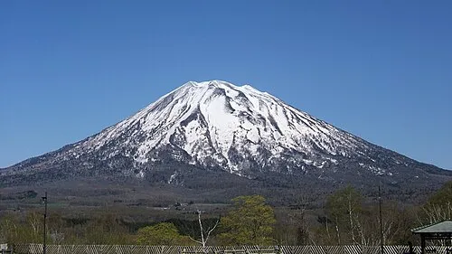 Yōtei-zan Mountain, Kutchan Chō12 km NE
-
Mount Usu Mountain, Japan15 km E
-
 Raiden-yama Mountain, Rankoshi Chō22 km NW
-
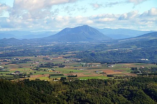 Mount Shiribetsu Mountain, Rusutsu Mura19 km E
Sources & licences
Data last updated: · 2 independent sources