
- Population
- 46,083
- 46.1K
- Elevation
- 11 m
- above sea level
- Local time
- UTC+09:00
- Asia/Tokyo · UTC+09:00
- Airports
- HKD Hakodate Airport16 km
- OIR Okushiri Airport104 km
About Hokuto
Hokuto is a city. Location: Hokuto Shi, Hokkaido. Population: 46,083. Elevation: 11 m.
Hokuto (北斗市, Hokuto-shi) is a city in the center of the Oshima Subprefecture in Japan's northern island of Hokkaido. It serves as a bedroom community for Hakodate, to the east of the city. Hokuto was formed on February 1, 2006, from merging the town of Kamiiso, from Kamiiso District, and the town of Ōno, from Kameda District. Hokuto is the third city to be established in Oshima. (The second, Kameda, no longer exists, being dissolved just two years after its founding in 1971).
Source: Wikipedia · CC BY-SA 4.0
Travel notes for Hokuto
From Wikivoyage
Hokuto (北斗市, Hokuto-shi) is a small city in Hokkaido.
Understand+
Hokuto is located at the southern end of Japan's northernmost prefecture, Hokkaido, and is immediately west of Hakodate. The city was formed by the merger of Kamiiso and Ōno towns on February 1, 2006. It is now the 2nd largest city in Oshima Subprefecture with a population of about 50,000 people.
Hokuto is the northern terminus of the Hokkaido Shinkansen. Shin-Hakodate-Hokuto Station is located at the former site of Oshima-Ono Station.
Tourist information sites:
The local tourist association has a multilingual guide site.
The city government's official site has a Japanese-only tourism section.
Get in+
Shin-Hakodate-Hokuto Station can be reached from Sapporo via the Hokuto Limited Express line in three and a half hours, or from Tokyo via the Tohoku-Hokkaido Shinkansen in as little as four hours.
The nearest airport is Hakodate Airport, which is about 45 minutes away by car or taxi.
Source: Wikivoyage · CC BY-SA 4.0 · abridged
Places bordering Hokuto
- Hakodate
- Kikonai
- Honchō
- Mori-machi
- Assabu Chō
Population of Hokuto over time
| 2010 | 48,032 | |
|---|---|---|
| 2015 | 46,390 | |
| 2020 | 45,661 |
Censuses and official estimates; source: Wikidata.
Climate of Hokuto
Best months for sightseeingBest months for sightseeing: June–September.
This month · November
A wet month
Day 10° · Night 3° · Rain 112 mm
- Hottest month
- August (day 25°)
- Coldest month
- January (night -5°)
- Wettest month
- September (173 mm)
- Driest month
- February (74 mm)
Bars: average monthly low and high temperature. Below: precipitation. Monthly averages for 1970–2000 at about 18 km resolution, adjusted for elevation. Highlighted months are mild and relatively dry. Source: WorldClim 2.1 (CC BY 4.0).
Show values as a table
| Month | Jan | Feb | Mar | Apr | May | Jun | Jul | Aug | Sep | Oct | Nov | Dec |
|---|---|---|---|---|---|---|---|---|---|---|---|---|
| Average high (°C) | 1° | 2° | 5° | 11° | 15° | 19° | 23° | 25° | 22° | 17° | 10° | 4° |
| Average low (°C) | -5° | -4° | -2° | 4° | 9° | 13° | 17° | 19° | 15° | 9° | 3° | -2° |
| Precipitation (mm) | 87 | 74 | 76 | 85 | 90 | 97 | 138 | 160 | 173 | 113 | 112 | 94 |
Other places to visit in this season: June July August September
How to get to Hokuto
The nearest airport is Hakodate Airport (HKD), 16 km to the east as the crow flies. The nearest large city is Hakodate, 10 km to the southeast.
Airports
- Hakodate Airport (HKD) Hakodate 16 kmeast
- Okushiri Airport (OIR) Okushiri Island 104 kmwest
- Aomori Airport (AOJ) Aomori 120 kmsouth
Nearby large cities
- Hakodate Population: 275.7K 10 kmsoutheast
- Aomori Population: 298.4K 111 kmsouth
- Tomakomai Population: 174.8K 121 kmnortheast
- Hirosaki Population: 168.7K 137 kmsouth
- Sapporo Population: 2M 151 kmnortheast
Straight-line distances; road distances are longer. Airport data: OurAirports.
Day trips from Hokuto
Within 100 km: 3 historic and cultural sites, 13 natural sites, 13 lakes, rivers and coasts.
0–25 km4 places
- Shiryōkaku Historic site 11 kmE
- Hakodate Arena Landmark 13 kmE
- Mount Hakodate Mountain 9 kmSE
- Oshima Peninsula Natural site 23 kmNW
25–60 km9 places
- Mount Maru Mountain 38 kmE
- Komaga-dake Mountain 28 kmN
- Daisengen-dake Mountain 47 kmSW
- Shirakami Misaki Natural site 59 kmSW
60–100 km16 places
- Lake Jūsan Lake 91 kmS
- Makomanai-gawa River 91 kmNW
- Toya Lake Lake 90 kmN
- Shiribeshi-Toshibetsu River River 94 kmNW
Straight-line distances.
Nearby attractions & nature
Everything nearby-
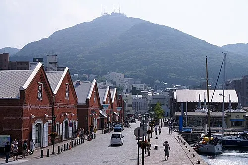 Mount Hakodate Mountain, Hakodate Shi8.5 km SE
-
Shiryōkaku Historic site, Hokkaido11 km E
-
Hakodate Arena Landmark, Hokkaido13 km E
-
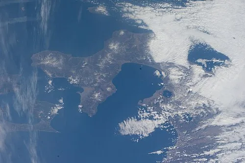 Oshima Peninsula Natural site, Japan23 km NW
Sources & licences
Data last updated: · 2 independent sources