- Population
- 338,909
- 338.9K
- Elevation
- 61 m
- above sea level
- Local time
- UTC+09:00
- Asia/Tokyo · UTC+09:00
- Places inside
- 2
- listed under Kōchi Shi
- Airports
- KCZ Kochi Ryoma Airport16 km
- MYJ Matsuyama Airport79 km
About Kōchi Shi
Kōchi Shi is a district. Location: Kochi, Japan. Population: 338,909.
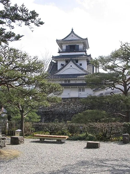
Kōchi (高知市, Kōchi-shi; Japanese pronunciation: [kó̞ò̞.c̟͡ɕì, kò̞ó̞.c̟͡ɕi̥.ɕì, kó̞ó̞.c̟͡ɕi̥-], locally [kò̞ó̞.c̟͡ɕí]) is the capital city of Kōchi Prefecture located on the island of Shikoku in Japan. With over 40% of the prefectural population, Kōchi is the main commercial and industrial centre and the "primate city" of the prefecture. As of 1 April 2023, the city had an estimated population of 311,224 in 163,479 households, and a population density of 1,000 persons per km2.
Source: Wikipedia · CC BY-SA 4.0
Places bordering Kōchi Shi
- Nankoku Shi
- Tosa Shi
- Tosa-gun
- Ino
Twin towns and sister cities of Kōchi Shi
- Fresno· United States
- Kitami· Japan
Source: Wikidata. Only places with a page on this site are shown.
Population of Kōchi Shi over time
| 2010 | 343,393 | |
|---|---|---|
| 2015 | 337,190 | |
| 2021 | 325,535 |
Censuses and official estimates; source: Wikidata.
Climate of Kōchi Shi
Best months for sightseeingBest months for sightseeing: April–June, October–November.
This month · November
A good month to visit
Day 18° · Night 9° · Rain 102 mm
- Hottest month
- August (day 31°)
- Coldest month
- January (night 2°)
- Wettest month
- June (326 mm)
- Driest month
- January (52 mm)
Bars: average monthly low and high temperature. Below: precipitation. Monthly averages for 1970–2000 at about 18 km resolution, adjusted for elevation. Highlighted months are mild and relatively dry. Source: WorldClim 2.1 (CC BY 4.0).
Show values as a table
| Month | Jan | Feb | Mar | Apr | May | Jun | Jul | Aug | Sep | Oct | Nov | Dec |
|---|---|---|---|---|---|---|---|---|---|---|---|---|
| Average high (°C) | 11° | 12° | 15° | 20° | 24° | 26° | 30° | 31° | 28° | 23° | 18° | 13° |
| Average low (°C) | 2° | 3° | 6° | 12° | 16° | 20° | 24° | 24° | 21° | 15° | 9° | 4° |
| Precipitation (mm) | 52 | 88 | 135 | 215 | 238 | 326 | 297 | 111 | 288 | 168 | 102 | 56 |
Other places to visit in this season: April May June October November
How to get to Kōchi Shi
The nearest airport is Kochi Ryoma Airport (KCZ), 16 km to the east as the crow flies. The nearest large city is Kochi, 5 km to the southeast.
Airports
- Kochi Ryoma Airport (KCZ) Nankoku 16 kmeast
- Matsuyama Airport (MYJ) Matsuyama 79 kmwest
- Takamatsu Airport (TAK) Takamatsu 84 kmnortheast
Nearby large cities
- Kochi Population: 332.1K 5 kmsoutheast
- Niihama Population: 123.1K 46 kmnorthwest
- Saijō Population: 104.8K 47 kmnorthwest
- Imabari Population: 171K 71 kmnorthwest
- Matsuyama Population: 511.2K 74 kmnorthwest
Straight-line distances; road distances are longer. Airport data: OurAirports.
Places in Kōchi Shi
2 placesKochi
Population: 332.1K
Nearby attractions & nature
Everything nearby-
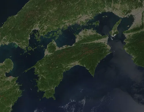 Shikoku Island, Japan18 km N
-
Mount Inamura Mountain, Tosa-chō22 km NW
Sources & licences
Data last updated: · 2 independent sources