Minami-yamashiro Mura
Local name: 南山城村
Located in Sōraku, Kyoto Coordinates: 34°45′58″ N 136°00′09″ E

- Population
- 3,047
- 3K
- Elevation
- 198 m
- above sea level
- Local time
- UTC+09:00
- Asia/Tokyo · UTC+09:00
- Airports
- ITM Osaka Itami International Airport51 km
- UKB Kobe Airport73 km
About Minami-yamashiro Mura
Minami-yamashiro Mura is a municipality. Location: Sōraku, Kyoto. Population: 3,047. Elevation: 198 m.
Minamiyamashiro (南山城村, Minamiyamashiro-mura) is a village located in Sōraku District, Kyoto Prefecture, Japan. As of 1 July 2023 the village has an estimated population of 2,472 in 1219 households and a population density of 39 persons per km2. The total area of the village is 64.11 square kilometres (24.75 sq mi).
Source: Wikipedia · CC BY-SA 4.0
Photos of Minami-yamashiro Mura
-

Simiwiki55 · CC BY-SA 4.0 -

Simiwiki55 · CC BY-SA 4.0 -

Gohachiyasu1214 · CC BY-SA 4.0 -

Vfjls · CC BY-SA 4.0 -

Miya.m · CC BY-SA 4.0


Places bordering Minami-yamashiro Mura
- Nara-shi
- Koka-Shi
- Kasagi
- Wazuka Chō
- Iga
Population of Minami-yamashiro Mura over time
| 2010 | 3,078 | |
|---|---|---|
| 2015 | 2,652 | |
| 2021 | 2,329 |
Censuses and official estimates; source: Wikidata.
Climate of Minami-yamashiro Mura
Best months for sightseeingBest months for sightseeing: May–June, September–October.
This month · November
Outside the best season
Day 15° · Night 6° · Rain 78 mm
Better nearby cities in November
- Fujinomiya · 243 km east18°
- Fuji · 248 km east20°
- Kofu · 254 km northeast17°
- Hottest month
- August (day 30°)
- Coldest month
- January (night -1°)
- Wettest month
- June (240 mm)
- Driest month
- December (42 mm)
Bars: average monthly low and high temperature. Below: precipitation. Monthly averages for 1970–2000 at about 18 km resolution, adjusted for elevation. Highlighted months are mild and relatively dry. Source: WorldClim 2.1 (CC BY 4.0).
Show values as a table
| Month | Jan | Feb | Mar | Apr | May | Jun | Jul | Aug | Sep | Oct | Nov | Dec |
|---|---|---|---|---|---|---|---|---|---|---|---|---|
| Average high (°C) | 8° | 8° | 12° | 18° | 22° | 25° | 29° | 30° | 26° | 21° | 15° | 10° |
| Average low (°C) | -1° | -1° | 1° | 7° | 12° | 17° | 21° | 22° | 18° | 12° | 6° | 1° |
| Precipitation (mm) | 50 | 66 | 108 | 150 | 157 | 240 | 218 | 162 | 216 | 134 | 78 | 42 |
Other places to visit in this season: May June September October
How to get to Minami-yamashiro Mura
The nearest airport is Osaka Itami International Airport (ITM), 51 km to the west as the crow flies. The nearest large city is Nara, 20 km to the southwest.
Airports
- Osaka Itami International Airport (ITM) Osaka 51 kmwest
- Kobe Airport (UKB) Kobe 73 kmwest
- Chubu Centrair International Airport (NGO) Tokoname 74 kmeast
Nearby large cities
- Nara Population: 367.4K 20 kmsouthwest
- Uji Population: 192.9K 23 kmnorthwest
- Kusatsu Population: 143.9K 28 kmnorth
- Ōtsu Population: 345.1K 29 kmnorthwest
- Ikoma Population: 120.7K 29 kmwest
Straight-line distances; road distances are longer. Airport data: OurAirports.
Day trips from Minami-yamashiro Mura
Within 100 km: 32 historic and cultural sites, 46 natural sites, 36 lakes, rivers and coasts.
0–25 km3 places
- Mount Wakakusa Mountain 16 kmSW
- Koofukuji Attraction 18 kmSW
- Tōdai-ji Attraction 17 kmSW
25–60 km58 places
- Kumozu River River 52 kmE
- Mount Miwa Mountain 29 kmSW
- Mount Amanokagu Mountain 34 kmSW
- Mount Miminashi Mountain 33 kmSW
60–100 km53 places
- Tōshi-jima Island 85 kmE
- Himakajima Island 92 kmE
- Mount Rokkō Mountain 68 kmW
- Sakate-jima Island 84 kmE
Straight-line distances.
Nearby attractions & nature
Everything nearby-
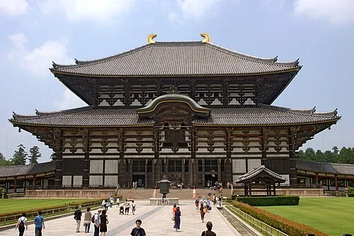 Tōdai-ji Attraction, Nara-shi17 km SW
-
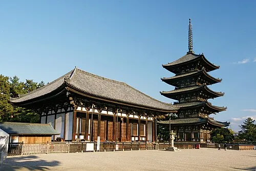 Koofukuji Attraction, Nara-shi18 km SW
-
 Mount Wakakusa Mountain, Nara-shi16 km SW
Other cities and towns in Sōraku

Sources & licences
Data last updated: · 2 independent sources