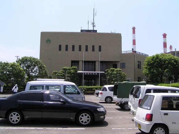
- Population
- 10,321
- 10.3K
- Elevation
- 2 m
- above sea level
- Local time
- UTC+09:00
- Asia/Tokyo · UTC+09:00
- Airports
- SHM Nanki Shirahama Airport61 km
- KIX Kansai International Airport104 km
About Udono
Udono is a town. Location: Kihou-chō, Minamimuro-gun. Population: 10,321. Elevation: 2 m.
Udono (鵜殿村, Udono-mura) was a village located in Minamimuro District, Mie Prefecture, Japan. As of 2004 (the last official figures before its dissolution), the village had an estimated population of 4,852 and a population density of 1684.7 persons per km2. The total area was 2.88 km2. On January 10, 2006, Udono was merged into the expanded town of Kihō and thus no longer exists as an independent municipality. As a result, this merger, all villages in Mie Prefecture have ceased to exist.
Source: Wikipedia · CC BY-SA 4.0
At a glance
- Built
- 1894
- Area
- 2.9 km²
Source: Wikidata
Climate of Udono
Best months for sightseeingBest months for sightseeing: May–June, October.
This month · November
A wet month
Day 18° · Night 10° · Rain 137 mm
Better nearby cities in November
- Kochi · 230 km west18°
- Fujinomiya · 290 km northeast18°
- Fuji · 292 km northeast20°
- Hottest month
- August (day 30°)
- Coldest month
- January (night 3°)
- Wettest month
- June (308 mm)
- Driest month
- December (61 mm)
Bars: average monthly low and high temperature. Below: precipitation. Monthly averages for 1970–2000 at about 18 km resolution, adjusted for elevation. Highlighted months are mild and relatively dry. Source: WorldClim 2.1 (CC BY 4.0).
Show values as a table
| Month | Jan | Feb | Mar | Apr | May | Jun | Jul | Aug | Sep | Oct | Nov | Dec |
|---|---|---|---|---|---|---|---|---|---|---|---|---|
| Average high (°C) | 11° | 12° | 15° | 19° | 23° | 25° | 29° | 30° | 27° | 23° | 18° | 14° |
| Average low (°C) | 3° | 3° | 6° | 11° | 15° | 19° | 23° | 24° | 21° | 15° | 10° | 5° |
| Precipitation (mm) | 69 | 87 | 142 | 198 | 208 | 308 | 228 | 214 | 293 | 201 | 137 | 61 |
How to get to Udono
The nearest airport is Nanki Shirahama Airport (SHM), 61 km to the west as the crow flies. For international flights: Kansai International Airport (KIX) (104 km). The nearest large city is Kashiwara, 82 km to the north.
Airports
- Nanki Shirahama Airport (SHM) Shirahama 61 kmwest
- Kansai International Airport (KIX) Osaka 104 kmnorthwest
- Kobe Airport (UKB) Kobe 123 kmnorthwest
Nearby large cities
- Kashiwara Population: 120.9K 82 kmnorth
- Kawachi-Nagano Population: 101.7K 88 kmnorthwest
- Kashihara-shi Population: 124.5K 88 kmnorth
- Tondabayashi Population: 132.9K 93 kmnorthwest
- Wakayama Population: 356.7K 95 kmnorthwest
Straight-line distances; road distances are longer. Airport data: OurAirports.
Day trips from Udono
Within 100 km: 1 historic or cultural site, 18 natural sites, 5 lakes, rivers and coasts.
0–25 km1 place
- Kumano River River 1 kmS
25–60 km7 places
- Kii Ōshima Island 34 kmSW
- Mount Ōdaigahara Mountain 50 kmN
- Choshi River River 46 kmNE
- Hakken-san Mountain 49 kmN
60–100 km16 places
- Kashiko Island Island 98 kmNE
- Mount Miwa Mountain 89 kmN
- Mount Amanokagu Mountain 86 kmN
- Mount Miminashi Mountain 88 kmN
Straight-line distances.
Sources & licences
Data last updated: · 2 independent sources