- Population
- 8,016
- 8K
- Elevation
- 155 m
- above sea level
- Local time
- UTC+09:00
- Asia/Tokyo · UTC+09:00
- Airports
- HAC Hachijojima Airport2 km
- MYE Miyakejima Airport110 km
About Hachijō Machi
Hachijō Machi is a municipality. Location: Hachijō Shichō, Tokyo. Population: 8,016. Elevation: 155 m.
Hachijō (八丈町, Hachijō-machi) is a town located in Hachijō Subprefecture, Tokyo Metropolis, Japan. As of 1 December 2022, the town had an estimated population of 7,056, and a population density of 97.7 persons per km2. Its total area is 72.24 square kilometres (27.89 sq mi). Electric power for the town is provided by a geothermal power station and a wind farm.
Source: Wikipedia · CC BY-SA 4.0
Photos of Hachijō Machi
-

Hachijojima Island っ at Japanese Wikipedia · CC BY-SA 3.0

Twin towns and sister cities of Hachijō Machi
- Maui County· United States
Source: Wikidata. Only places with a page on this site are shown.
Population of Hachijō Machi over time
| 2010 | 8,231 | |
|---|---|---|
| 2015 | 7,613 | |
| 2021 | 6,977 |
Censuses and official estimates; source: Wikidata.
Climate of Hachijō Machi
Best months for sightseeingBest months for sightseeing: April–June, October–November.
This month · November
A good month to visit
Day 21° · Night 15° · Rain 219 mm
- Hottest month
- August (day 29°)
- Coldest month
- February (night 8°)
- Wettest month
- October (332 mm)
- Driest month
- December (133 mm)
Bars: average monthly low and high temperature. Below: precipitation. Monthly averages for 1970–2000 at about 18 km resolution, adjusted for elevation. Highlighted months are mild and relatively dry. Source: WorldClim 2.1 (CC BY 4.0).
Show values as a table
| Month | Jan | Feb | Mar | Apr | May | Jun | Jul | Aug | Sep | Oct | Nov | Dec |
|---|---|---|---|---|---|---|---|---|---|---|---|---|
| Average high (°C) | 15° | 14° | 16° | 20° | 22° | 25° | 28° | 29° | 28° | 24° | 21° | 17° |
| Average low (°C) | 9° | 8° | 10° | 14° | 17° | 20° | 23° | 24° | 23° | 19° | 15° | 11° |
| Precipitation (mm) | 134 | 146 | 200 | 212 | 255 | 324 | 177 | 208 | 282 | 332 | 219 | 133 |
Other places to visit in this season: April May June October November
How to get to Hachijō Machi
The nearest airport is Hachijojima Airport (HAC), 2 km to the northwest as the crow flies. The nearest large city is Numazu, 237 km to the north.
Airports
- Hachijojima Airport (HAC) Hachijojima 2 kmnorthwest
- Miyakejima Airport (MYE) Miyakejima 110 kmnorth
- Oshima Airport (OIM) Izu Oshima 190 kmnorth
Nearby large cities
- Numazu Population: 189.5K 237 kmnorth
- Mishima Population: 107.9K 237 kmnorth
- Yaizu Population: 139.6K 239 kmnorthwest
- Fujieda Population: 145K 241 kmnorthwest
- Yokosuka Population: 409.5K 242 kmnorth
Straight-line distances; road distances are longer. Airport data: OurAirports.
Day trips from Hachijō Machi
Within 100 km: 5 lakes, rivers and coasts.
0–25 km2 places
- Hachijojima Island Island 1 kmNW
- Ko-jima Island 10 kmW
60–100 km3 places
- Mikura-jima Island 87 kmN
- Aoga Shima Island 72 kmS
- Inamba-jima Island 76 kmNW
Straight-line distances.
Nearby attractions & nature
Everything nearby-
Hachijojima Island Island, Hachijō Shichō0.8 km NW
-
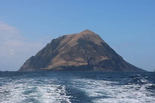 Ko-jima Island, Japan10 km W
Sources & licences
Data last updated: · 2 independent sources