- Population
- 17,501
- 17.5K
- Elevation
- 22 m
- above sea level
- Local time
- UTC+09:00
- Asia/Tokyo · UTC+09:00
- Places inside
- 1
- listed under Yurihama Chō
- Airports
- TTJ Tottori Sand Dunes Conan Airport24 km
- YGJ Yonago Kitaro Airport / JASDF Miho Air Base61 km
About Yurihama Chō
Yurihama Chō is a municipality. Location: Tōhaku-gun, Tottori. Population: 17,501. Elevation: 22 m.
Yurihama (湯梨浜町, Yurihama-chō) is a town located in Tōhaku District, Tottori Prefecture, Japan. As of 31 December 2022, the town had an estimated population of 16,515 in 6452 households and a population density of 210 persons per km2. The total area of the town is 77.94 square kilometres (30.09 sq mi).
Source: Wikipedia · CC BY-SA 4.0
Photos of Yurihama Chō
-
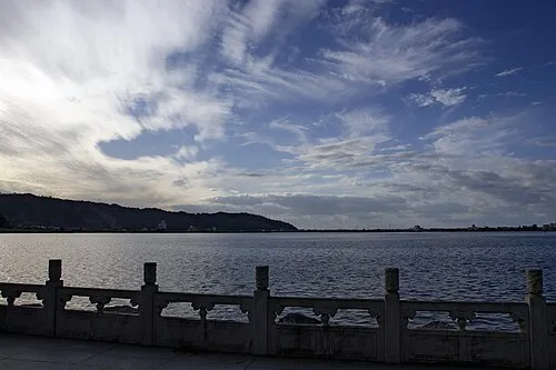
Lake Tōgō 663highland · CC BY 2.5

Travel notes for Yurihama Chō
From Wikivoyage
Yurihama (湯梨浜町 Yurihama-chō) is a town in Tottori Prefecture.
Understand+
The town started in 2004 by merging three small municipalities, Hawai, Tomari and Togo. The name was coined combining kanji for hot springs (湯), sand pears (梨) and beaches (浜).
Tourist Information Sites:
The local tourist association has a Japanese-only guide site.
The town's hot spring areas, Togo and Hawai has a multilingual guide site.
Get in+
By plane:
Tottori Airport (鳥取空港 TTJ IATA), Tottori (Airport buses connect to Matsuzaki Station (40 min). Alternately, a train goes to the airport.). This airport is in a neighboring city. (updated Jun 2020)
By train:
The JR San-in Line runs through Yurihama with two stations in town: Tomari Station and Matsuzaki Station.
By car:
The San-in Road and Aoya-Hawai Road run through Yurihama along the coast. Route 22 runs along the southern side of Lake Togo.
Source: Wikivoyage · CC BY-SA 4.0 · abridged
Places bordering Yurihama Chō
- Tottori-shi
- Kurayoshi
- Hokuei Chō
Population of Yurihama Chō over time
| 2010 | 17,029 | |
|---|---|---|
| 2015 | 16,550 | |
| 2021 | 15,972 |
Censuses and official estimates; source: Wikidata.
Climate of Yurihama Chō
Best months for sightseeingBest months for sightseeing: May–June, October.
This month · November
A wet month
Day 16° · Night 7° · Rain 112 mm
Better nearby cities in November
- Kochi · 217 km south18°
- Ōita · 327 km southwest18°
- Beppu · 329 km southwest17°
- Hottest month
- August (day 31°)
- Coldest month
- February (night 0°)
- Wettest month
- July (229 mm)
- Driest month
- December (102 mm)
Bars: average monthly low and high temperature. Below: precipitation. Monthly averages for 1970–2000 at about 18 km resolution, adjusted for elevation. Highlighted months are mild and relatively dry. Source: WorldClim 2.1 (CC BY 4.0).
Show values as a table
| Month | Jan | Feb | Mar | Apr | May | Jun | Jul | Aug | Sep | Oct | Nov | Dec |
|---|---|---|---|---|---|---|---|---|---|---|---|---|
| Average high (°C) | 7° | 8° | 12° | 18° | 23° | 26° | 30° | 31° | 27° | 21° | 16° | 11° |
| Average low (°C) | 0° | 0° | 2° | 8° | 13° | 17° | 22° | 23° | 19° | 12° | 7° | 3° |
| Precipitation (mm) | 117 | 114 | 115 | 129 | 136 | 198 | 229 | 141 | 228 | 126 | 112 | 102 |
How to get to Yurihama Chō
The nearest airport is Tottori Sand Dunes Conan Airport (TTJ), 24 km to the east as the crow flies. For international flights: Okayama Momotaro Airport (OKJ) (80 km). The nearest large city is Tottori-shi, 30 km to the east.
Airports
- Tottori Sand Dunes Conan Airport (TTJ) Tottori 24 kmeast
- Yonago Kitaro Airport / JASDF Miho Air Base (YGJ) Yonago 61 kmwest
- Okayama Momotaro Airport (OKJ) Okayama 80 kmsouth
Nearby large cities
- Tottori-shi Population: 188.5K 30 kmeast
- Tsuyama Population: 102.3K 47 kmsouth
- Yonago Population: 148.7K 52 kmwest
- Matsue Population: 203.6K 78 kmwest
- Kurashiki Population: 483.6K 100 kmsouth
Straight-line distances; road distances are longer. Airport data: OurAirports.
Day trips from Yurihama Chō
Within 100 km: 4 historic and cultural sites, 11 natural sites, 15 lakes, rivers and coasts.
0–25 km2 places
- Lake Tōgō Lake 2 kmNW
- Tenjin River River 6 kmNW
25–60 km10 places
- Sendai River River 27 kmE
- Tottori Castle ruins Historic site 30 kmE
- Mount Hyōno Mountain 57 kmE
- Mount Nagi Mountain 42 kmSE
60–100 km18 places
- Maruyama River River 86 kmE
- Ibo Gawa River 100 kmSE
- Ako Castle Historic site 92 kmSE
- Mount Dōgo Mountain 76 kmSW
Straight-line distances.
Places in Yurihama Chō
1 placeBar: population relative to the most populous place in this list.
Nearby attractions & nature
Everything nearby-
Lake Tōgō Lake, Tottori1.8 km NW
-
Tenjin River River, Tottori5.9 km NW
Sources & licences
Data last updated: · 2 independent sources