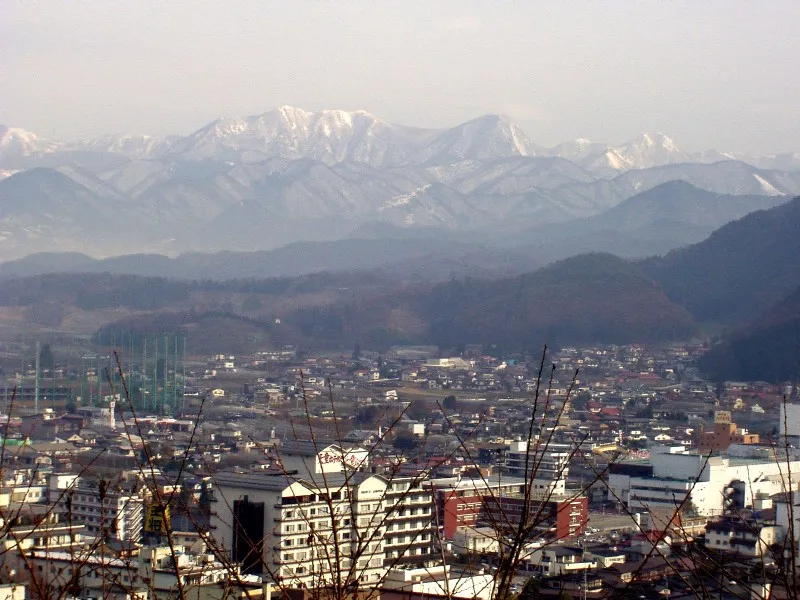
- Population
- 65,393
- 65.4K
- Elevation
- 108 m
- above sea level
- Local time
- UTC+09:00
- Asia/Tokyo · UTC+09:00
- Airports
- GAJ Yamagata Airport6 km
- SDJ Sendai Airport53 km
About Tendō
Tendō is a city. Location: Tendō Shi, Yamagata. Population: 65,393. Elevation: 108 m.
Tendō (天童市, Tendō-shi) is a city located in Yamagata Prefecture, Japan. As of 1 February 2020, the city had an estimated population of 61,947 in 22392 households, and a population density of 550 persons per km2. The total area of the city is 113.01 square kilometres (43.63 square miles).
Source: Wikipedia · CC BY-SA 4.0
Travel notes for Tendō
From Wikivoyage
Tendo (天童 Tendō) is a city in Yamagata, Japan, known for exactly one thing: making pieces for shogi, also known as Japanese chess.
Understand+
Local estimates claim that as many as 95% of the shogi pieces produced in Japan are made in Tendo. (Presumably, this was phrased to exclude any plastic sets that are made abroad.) Originally, only Yamagata wood was used in making shogi pieces. Today, wood imported from Cambodia, China, and Thailand fills the bulk of production, while native Japanese boxwood from Kagoshima and Mikurajima is reserved for the high-grade pieces.
Shogi is believed to have come to Japan in the Heian period, and it shares a common ancestor with Western chess. It also shares some pieces and strategies with chess, though pieces can be promoted to gain new movements, and captured pieces can be returned to play as turncoats against their original owner.
Tourist information site:
The local tourist association has a Japanese-only guide site. with integrated Google Translate.
Get in+
JR Tendo Station is on the Yamagata Shinkansen, about three hours from Tokyo and one stop north of Yamagata. It's also on the JR Ou Main Line between Fukushima and Aomori, about 20 minutes from Yamagata.
Source: Wikivoyage · CC BY-SA 4.0 · abridged
Places bordering Tendō
- Yamagata Shi
- Sagae-shi
- Nakayama Machi
- Kahoku Chō
Twin towns and sister cities of Tendō
- Abashiri· Japan
- Tagajō-shi· Japan
- Tsuchiura-shi· Japan
- Tatebayashi· Japan
Source: Wikidata. Only places with a page on this site are shown.
Population of Tendō over time
| 2010 | 62,214 | |
|---|---|---|
| 2015 | 62,194 | |
| 2021 | 61,981 |
Censuses and official estimates; source: Wikidata.
Climate of Tendō
Best months for sightseeingBest months for sightseeing: May–June, September.
This month · November
A wet month
Day 12° · Night 4° · Rain 108 mm
Better nearby cities in November
- Kofu · 339 km southwest17°
- Isehara · 342 km south18°
- Odawara · 361 km south19°
- Hottest month
- August (day 29°)
- Coldest month
- January (night -4°)
- Wettest month
- August (160 mm)
- Driest month
- March (78 mm)
Bars: average monthly low and high temperature. Below: precipitation. Monthly averages for 1970–2000 at about 18 km resolution, adjusted for elevation. Highlighted months are mild and relatively dry. Source: WorldClim 2.1 (CC BY 4.0).
Show values as a table
| Month | Jan | Feb | Mar | Apr | May | Jun | Jul | Aug | Sep | Oct | Nov | Dec |
|---|---|---|---|---|---|---|---|---|---|---|---|---|
| Average high (°C) | 2° | 3° | 7° | 15° | 21° | 24° | 27° | 29° | 24° | 18° | 12° | 6° |
| Average low (°C) | -4° | -3° | -1° | 5° | 11° | 16° | 20° | 21° | 17° | 10° | 4° | -1° |
| Precipitation (mm) | 101 | 82 | 78 | 87 | 87 | 120 | 155 | 160 | 151 | 110 | 108 | 102 |
How to get to Tendō
The nearest airport is Yamagata Airport (GAJ), 6 km to the north as the crow flies. For international flights: Sendai Airport (SDJ) (53 km). The nearest large city is Yamagata, 13 km to the south.
Airports
- Yamagata Airport (GAJ) Higashine 6 kmnorth
- Sendai Airport (SDJ) Natori 53 kmsoutheast
- Shonai Airport (SYO) Shonai 72 kmnorthwest
Nearby large cities
- Yamagata Population: 248.8K 13 kmsouth
- Sendai Population: 1.1M 45 kmeast
- Ōsaki Population: 128.8K 59 kmnortheast
- Tsuruoka Population: 125.4K 63 kmnorthwest
- Fukushima Population: 294.2K 68 kmsouth
Straight-line distances; road distances are longer. Airport data: OurAirports.
Day trips from Tendō
Within 100 km: 2 historic and cultural sites, 20 natural sites, 16 lakes, rivers and coasts.
0–25 km2 places
- Mount Funagata Mountain 25 kmNE
- Mount Zaō Mountain 24 kmS
25–60 km9 places
- Abukuma River River 59 kmSE
- Mount Asahi Mountain 40 kmW
- Dewa Sanzan Mountain 46 kmNW
- Asahi Dake Mountain 40 kmW
60–100 km27 places
- Miyago Jima Island 69 kmE
- Awashima Island Island 99 kmW
- Tashiro Jima Island 92 kmE
- Zuigan Ji Attraction 60 kmE
Straight-line distances.
Tendō and similar cities
Side by side with cities of similar size in the same country: population, elevation and climate.
| Measure | Tendō | Mitoyo | Sodegaura | Hita |
|---|---|---|---|---|
| Population | 65.4K | 65.7K | 64.9K | 64.9K |
| Elevation | 108 m | 67 m | 18 m | 90 m |
| Summer day (hottest month) | 29° | 31° | 30° | 31° |
| Winter night (coldest month) | -4° | 1° | 1° | 1° |
| Annual rainfall | 1,341 mm | 1,527 mm | 1,523 mm | 2,157 mm |
| Best months | May–Jun, Sep | May–Jun, Oct | May–Jul, Sep–Oct | May–Jun, Oct |
| Distance | — | 757 km | 328 km | 1,018 km |
Climate values are 1970–2000 monthly averages; straight-line distance.
Nearby attractions & nature
Everything nearby-
 Mount Funagata Mountain, Shikama-cho25 km NE
-
Mount Zaō Mountain, Kaminoyama-shi24 km S
Sources & licences
Data last updated: · 2 independent sources