
- Elevation
- 1,862 m
- above sea level
- Local time
- UTC+01:00
- Europe/Podgorica · UTC+01:00
- Airports
- DBV Dubrovnik Ruđer Bošković Airport23 km
- TIV Tivat Airport27 km
About Bijela Gora
Bijela Gora is a mountain. Location: Montenegro. Elevation: 1,862 m.
Bijela Gora (Montenegrin Cyrillic | Бијела Гора, pronounced [bîjelaː ɡǒra], lit. "White Mountain") is a karstic high plateau between 1200–1500 m on the northern side of Mount Orjen in Montenegro. At 1862 m, Velika Jastrebica is the highest summit. It bears heavy glacial traces as a huge ice cap covered it during the last ice age. Sparsely inhabited pastures and vast virgin beech-fir forests are major resources.
Source: Wikipedia · CC BY-SA 4.0
Photos of Bijela Gora
-

Pavle Cikovac · CC BY-SA 4.0 -

Orjen · CC BY-SA 4.0 -

Orjen · CC BY-SA 4.0 -

Velika Jastrebica Orjen at German Wikipedia · CC BY-SA 3.0 -

Orjen Copyright · CC BY-SA 3.0


Climate of Bijela Gora
Best months for sightseeingBest months for sightseeing: June–August.
This month · November
A wet month
Day 5° · Night -3° · Rain 151 mm
- Hottest month
- July (day 18°)
- Coldest month
- February (night -7°)
- Wettest month
- November (151 mm)
- Driest month
- July (50 mm)
Bars: average monthly low and high temperature. Below: precipitation. Monthly averages for 1970–2000 at about 18 km resolution, adjusted for elevation. Highlighted months are mild and relatively dry. Source: WorldClim 2.1 (CC BY 4.0).
Show values as a table
| Month | Jan | Feb | Mar | Apr | May | Jun | Jul | Aug | Sep | Oct | Nov | Dec |
|---|---|---|---|---|---|---|---|---|---|---|---|---|
| Average high (°C) | 0° | -1° | 2° | 6° | 12° | 16° | 18° | 18° | 13° | 9° | 5° | 1° |
| Average low (°C) | -7° | -7° | -5° | -2° | 3° | 6° | 8° | 8° | 5° | 1° | -3° | -5° |
| Precipitation (mm) | 109 | 102 | 98 | 101 | 84 | 70 | 50 | 63 | 98 | 122 | 151 | 133 |
How to get to Bijela Gora
The nearest airport is Dubrovnik Ruđer Bošković Airport (DBV), 23 km to the west as the crow flies. The nearest large city is Podgorica, 62 km to the east.
Airports
- Dubrovnik Ruđer Bošković Airport (DBV) Dubrovnik 23 kmwest
- Tivat Airport (TIV) Tivat 27 kmsoutheast
- Podgorica Airport / Podgorica Golubovci Airbase (TGD) Podgorica 64 kmsoutheast
Nearby large cities
- Podgorica Population: 236.9K 62 kmeast
- Mostar Population: 104.5K 102 kmnorthwest
- Sarajevo Population: 696.7K 139 kmnorth
- Durrës Population: 195.9K 161 kmsoutheast
- Tirana Population: 418.5K 177 kmsoutheast
Straight-line distances; road distances are longer. Airport data: OurAirports.
Day trips from Bijela Gora
Within 100 km: 10 historic and cultural sites, 74 natural sites, 66 lakes, rivers and coasts.
0–25 km18 places
- Lake Grahovo Lake 10 kmNE
- Borova Mountain 10 kmNW
- Živa Natural site 18 kmE
- Dubovac Natural site 7 kmN
25–60 km26 places
- Saint Ignatius Church Attraction 36 kmW
- Daksa Island 41 kmW
- Otočić Sveti Andrija Island 49 kmW
- Otok Šipan Island 57 kmW
60–100 km106 places
- Mljet Island 84 kmW
- Česvinica Mountain 71 kmNW
- Zec Mountain 70 kmW
- Kosor Mountain 73 kmW
Straight-line distances.
Nearest towns and villages
-
Podstirovnik Village, Republika Srpska7.5 km W
-
 Vučija Village, Republika Srpska8.4 km N
-
 Crkvice Village, Kotor8.5 km SE
-
Nudo Village, Opština Nikšić7.8 km N
-
Bogojević Selo Village, Republika Srpska8.1 km W
-
Malov Do Village, Kotor8.1 km SE
Nearby attractions & nature
Everything nearby-
Velika Jastrebica Mountain, Montenegro0.7 km S
-
 Vučji Zub Mountain, Bosnia and Herzegovina2.7 km S
-
Orjen Mountain, Montenegro5 km S
-
Borovik Mountain, Montenegro4.3 km S
-
Dubovac Natural site, Republika Srpska7.2 km N
-
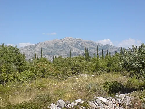 Sniježnica Mountain, Dubrovnik-Neretva County16 km W
-
Borova Mountain, Republika Srpska10 km NW
-
Debeli Brijeg Mountain, Croatia15 km SW
More nature in Montenegro
-
Mount Lovcen Mountain, Cetinje32 km SE
-
Živa Natural site, Montenegro18 km E
-
 Bay of Kotor Natural site, Montenegro22 km S
-
Lovcen National Park Natural site, Montenegro31 km SE
-
 Durmitor Mountain, Montenegro71 km NE
-
 Bobotov Kuk Mountain, Montenegro71 km NE
Sources & licences
Data last updated: · 2 independent sources