Beni Enzar
Local name: بْني نصار
Located in Nador Province, Oriental Coordinates: 35°15′36″ N 2°55′48″ W

- Population
- 61,786
- 61.8K
- Elevation
- 9 m
- above sea level
- Local time
- UTC+00:00
- Africa/Casablanca · UTC+00:00
- Airports
- MLN Melilla Airport3 km
- NDR Nador Al Aaroui International Airport31 km
About Beni Enzar
Beni Enzar is a town. Location: Nador Province, Oriental. Population: 61,786. Elevation: 9 m.
Beni Ansar is a town in Nador Province, Oriental, Morocco, located 12 km (7½ miles) north of the city of Nador. It is bordered on the north by the Spanish city of Melilla. According to the 2024 census, Beni Ansar has a population of 50,508. The port of Beni Ansar is one of the main ports of Morocco, serving the city of Nador (Beni Ansar port is usually referred to as Nador Port).
Source: Wikipedia · CC BY-SA 4.0
Photos of Beni Enzar
-
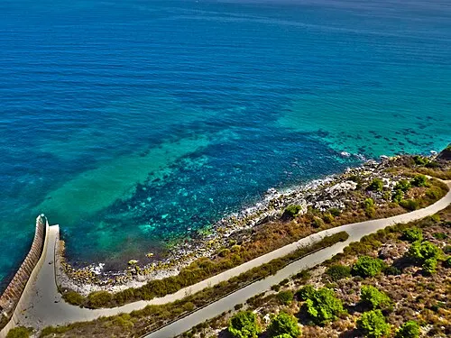
Playa del Quemado Lord_SKY · CC BY-SA 2.0 -
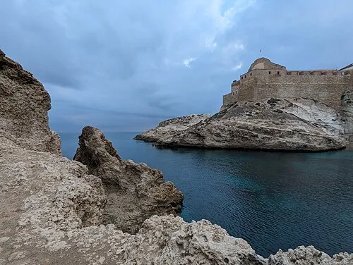
Cabo Trapana Olea · CC BY-SA 3.0 -
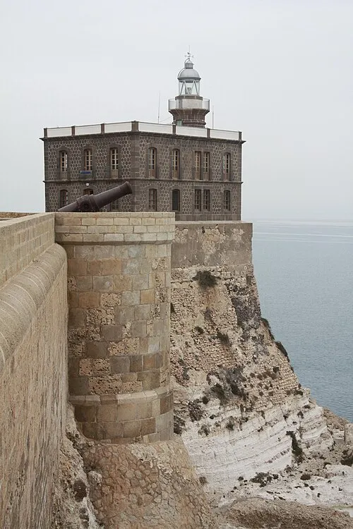
Melilla Lighthouse Fernando · CC BY-SA 2.0


Places bordering Beni Enzar
- Ihaddadene
- Bouarg
- Bni Chiker
- Melilla
Population of Beni Enzar over time
| 1994 | 23,897 | |
|---|---|---|
| 2004 | 31,800 | |
| 2014 | 56,582 | |
| 2024 | 50,508 |
Censuses and official estimates; source: Wikidata.
Climate of Beni Enzar
Best months for sightseeingBest months for sightseeing: April–June, October–November.
This month · November
A good month to visit
Day 20° · Night 13° · Rain 30 mm
- Hottest month
- August (day 31°)
- Coldest month
- January (night 9°)
- Wettest month
- January (57 mm)
- Driest month
- July (1 mm)
Bars: average monthly low and high temperature. Below: precipitation. Monthly averages for 1970–2000 at about 18 km resolution, adjusted for elevation. Highlighted months are mild and relatively dry. Source: WorldClim 2.1 (CC BY 4.0).
Show values as a table
| Month | Jan | Feb | Mar | Apr | May | Jun | Jul | Aug | Sep | Oct | Nov | Dec |
|---|---|---|---|---|---|---|---|---|---|---|---|---|
| Average high (°C) | 17° | 17° | 19° | 21° | 24° | 27° | 30° | 31° | 28° | 24° | 20° | 18° |
| Average low (°C) | 9° | 10° | 11° | 13° | 15° | 19° | 21° | 22° | 20° | 16° | 13° | 10° |
| Precipitation (mm) | 57 | 48 | 41 | 46 | 28 | 6 | 1 | 3 | 13 | 26 | 30 | 45 |
Other places to visit in this season: April May June October November
How to get to Beni Enzar
The nearest airport is Melilla Airport (MLN), 3 km to the northwest as the crow flies. For international flights: Nador Al Aaroui International Airport (NDR) (31 km). The nearest large city is Al Hoceima, 92 km to the west.
Airports
- Melilla Airport (MLN) Melilla 3 kmnorthwest
- Nador Al Aaroui International Airport (NDR) Al Aaroui 31 kmsouth
- Cherif Al Idrissi Airport (AHU) Al Hoceima 83 kmwest
Nearby large cities
- Al Hoceima Population: 395.6K 92 kmwest
- Almería Population: 196.9K 180 kmnorth
- Málaga Population: 592.3K 210 kmnorthwest
- Granada Population: 233.5K 222 kmnorth
- Tétouan Population: 415.8K 224 kmwest
Straight-line distances; road distances are longer. Airport data: OurAirports.
Day trips from Beni Enzar
Within 100 km: 30 historic and cultural sites, 8 natural sites, 16 lakes, rivers and coasts.
0–25 km40 places
- Playa de San Lorenzo Beach 3 kmN
- Playa de los Cárabos Beach 2 kmN
- Playa de la Hípica Beach 2 kmN
- Playa de Horcas Coloradas Beach 5 kmN
25–60 km7 places
- Chafarinas Islands Island 46 kmE
- Isabel II Island Lighthouse Landmark 46 kmE
- Isla del Rey Island 47 kmE
- Isabel II Island Island 46 kmE
60–100 km7 places
- Isla de Mar Island 88 kmW
- Peñón de Alhucemas Island 87 kmW
- Alhucemas Lighthouse Landmark 88 kmW
- Isla de Tierra Island 89 kmW
Straight-line distances.
Beni Enzar and similar cities
Side by side with cities of similar size in the same country: population, elevation and climate.
| Measure | Beni Enzar | Ouezzane | Ouarzazate | Tan-Tan |
|---|---|---|---|---|
| Population | 61.8K | 65.1K | 77.6K | 79.9K |
| Elevation | 9 m | 306 m | 1,113 m | 45 m |
| Summer day (hottest month) | 31° | 33° | 38° | 30° |
| Winter night (coldest month) | 9° | 5° | 2° | 10° |
| Annual rainfall | 344 mm | 738 mm | 170 mm | 79 mm |
| Best months | Apr–Jun, Oct–Nov | Apr–May, Oct–Nov | Feb–Apr, Oct–Nov | Nov–May |
| Distance | — | 247 km | 607 km | 1,081 km |
Climate values are 1970–2000 monthly averages; straight-line distance.
Nearby attractions & nature
Everything nearby-
Playa de la Hípica Beach, Melilla Municipality1.6 km N
-
Agustín Jerez Park Natural site, Melilla Municipality2.1 km N
-
Melilla Lighthouse Landmark, Melilla Municipality3.8 km N
-
Parque Forestal Juan Carlos I Natural site, Melilla Municipality2.5 km NW
-
Playa de los Cárabos Beach, Melilla Municipality2.2 km N
-
Finca Salama Mediumwave Transmitter Landmark, Melilla Municipality2.7 km NW
-
Teatro Cine Perelló Attraction, Melilla Municipality2.8 km N
-
Museo Eléctrico e Industrial Museum, Melilla Municipality3 km N
Other cities and towns in Nador Province
-
 Bni Chiker Municipality, Nador Province10 km NW
-
Nador Municipality, Nador Province9.4 km S
-
 Zeghanghane Town, Nador Province13 km SW
-
Bni Bouifrour Municipality, Nador Province13 km S
-
Bni Sidel Jbel Municipality, Nador Province14 km SW
-
Bouizazarene Ihaddad Municipality, Nador Province12 km S
Sources & licences
Data last updated: · 2 independent sources