- Population
- 145
- 145
- Elevation
- 166 m
- above sea level
- Local time
- UTC+01:00
- Europe/Warsaw · UTC+01:00
- Airports
- LUZ Lublin Airport69 km
- BQT Brest International Airport81 km
About Zbereże
Zbereże is a village. Location: Gmina Wola Uhruska, Włodawa County. Population: 145. Elevation: 166 m. The best months to visit are June–August. The nearest airport is Lublin Airport (69 km). Nearby sights include Sobibór Extermination Camp and Włodawa Ghetto.
Photos of Zbereże
-
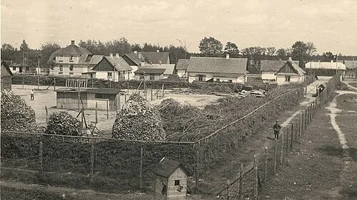
Sobibór Extermination Camp Anonymous Unknown author · Public domain

Climate of Zbereże
Best months for sightseeingBest months for sightseeing: June–August.
This month · November
A cold month
Day 5° · Night -1° · Rain 37 mm
- Hottest month
- July (day 23°)
- Coldest month
- January (night -7°)
- Wettest month
- July (78 mm)
- Driest month
- February (24 mm)
Bars: average monthly low and high temperature. Below: precipitation. Monthly averages for 1970–2000 at about 18 km resolution, adjusted for elevation. Highlighted months are mild and relatively dry. Source: WorldClim 2.1 (CC BY 4.0).
Show values as a table
| Month | Jan | Feb | Mar | Apr | May | Jun | Jul | Aug | Sep | Oct | Nov | Dec |
|---|---|---|---|---|---|---|---|---|---|---|---|---|
| Average high (°C) | -1° | 0° | 6° | 13° | 19° | 22° | 23° | 23° | 18° | 12° | 5° | 1° |
| Average low (°C) | -7° | -6° | -2° | 3° | 8° | 11° | 12° | 12° | 8° | 4° | -1° | -4° |
| Precipitation (mm) | 27 | 24 | 28 | 39 | 55 | 70 | 78 | 59 | 56 | 39 | 37 | 34 |
How to get to Zbereże
The nearest airport is Lublin Airport (LUZ), 69 km to the west as the crow flies. The nearest large city is Košice, 345 km to the southwest.
Airports
- Lublin Airport (LUZ) Lublin 69 kmwest
- Brest International Airport (BQT) Brest 81 kmnorth
- Warsaw Radom Airport (RDO) Radom 171 kmwest
Nearby large cities
- Košice Population: 225K 345 kmsouthwest
- Vilnius Population: 542.4K 382 kmnorth
- Kaunas Population: 289.4K 390 kmnorth
Straight-line distances; road distances are longer. Airport data: OurAirports.
Day trips from Zbereże
Within 100 km: 39 historic and cultural sites, 1 natural site.
0–25 km3 places
- Świerże Ghetto Historic site 20 kmS
- Włodawa Ghetto Historic site 19 kmNW
- Sobibór Extermination Camp Historic site 8 kmNW
25–60 km14 places
- Łysa Góra Mountain 28 kmSW
- Trawniki Concentration Camp Historic site 54 kmSW
- Biskupice Ghetto Historic site 58 kmSW
- Chełm Ghetto Historic site 32 kmSW
60–100 km23 places
- Lublin Concentration Camp (Lipowastraße) Historic site 80 kmW
- Hrubieszów Ghetto Historic site 68 kmS
- Lublin Ghetto Historic site 79 kmW
- Piaski Luterskie Ghetto Historic site 63 kmSW
Straight-line distances.
Nearby attractions & nature
Everything nearby-
Sobibór Extermination Camp Historic site, Włodawa7.9 km NW
-
Włodawa Ghetto Historic site, Włodawa19 km NW
-
Świerże Ghetto Historic site, Dorohusk20 km S
Sources & licences
Data last updated: